
The ATS Kulmbach is a German association football club from the city of Kulmbach, Bavaria.
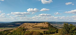
The Ehrenbürg is a double-peaked butte on the edge of the Franconian Jura in Bavaria, Germany. It is in the district of Forchheim in Upper Franconia, in the municipalities of Kirchehrenbach, Leutenbach and Wiesenthau. The north peak is the 513.9 m Walberla, the south peak the 531.7 m Rodenstein. The hill is popularly known as the Walberla.

The Veste Coburg is one of the best-preserved medieval fortresses of Germany. It is situated on a hill above the town of Coburg, in the Upper Franconia region of Bavaria.
Denkmäler deutscher Tonkunst is a historical edition of music from Germany, covering the Baroque and Classical periods.
Gräfenberg Castle is the older of two former castles in Gräfenberg in the Upper Franconian county of Forchheim in the south German state of Bavaria. Today, there is little left of the castle; it is classed as a burgstall and the site is in the area of Bahnhofstraße 11 to 21. The castle was first recorded in the year 1477; its last remains were removed from about 1563.

Gräfenberg Castle, also called Landesehre Castle, is a levelled hilltop castle near 360 m above sea level (NN) on the hill of Gräfenberg. It is located near Rottenberg in the market municipality of Hösbach in the district of Aschaffenburg in the south German state of Bavaria.
Moschendorf Castle is a levelled mediaeval hill castle at a height of 400 m above sea level (NHN) about 50 metres east of the village of Moschendorf, in the market municipality of Gößweinstein in the Franconian county of Forchheim in the south German state of Bavaria.
Oberweilersbach Castle is a levelled mediaeval lowland castle in the northwest of the parish of Oberweilersbach, in the municipality of Weilersbach in the county of Forchheim in the south German state of Bavaria.

Schlüsselstein Castle was a castle and the seat of a noble family, probably dating to the High Middle Ages, the remains of which lie above the town of Ebermannstadt in the Upper Franconian county of Forchheim in the south German state of Bavaria. The site is known locally as Burgstall Schlüsselstein.
The Altenburg fortification near Heroldsbach is a levelled early medieval fortified position at a height of 362 m above sea level (NHN), about 850 metres northwest of the church in Heroldsbach in the Upper Franconian county of Forchheim in the south German state of Bavaria. No historical or archaeological information is available for this sector fortification, but pottery finds from the interior of the site date to the Early Middle Ages. All that has survived is a double rampart system with a ditch. The site is protected by the state of Bavaria as monument number D-4-6331-0001: Frühmittelalterliche Abschnittsbefestigung "Altenburg".
Burk Castle is a levelled medieval motte and bailey castle in the area known as Beim Schanzbach, about 550 metres south-southwest of the church in Burk, a village in the borough of Forchheim in the county of Forchheim in the south German state of Bavaria.
Niedermirsberg Castle, also called the Steinhaus, is a levelled motte castle which is situated 780 metres west of the village church of Niedermirsberg, in the borough of Ebermannstadt in the county of Forchheim in the south German state of Bavaria.
Ebermannstadt Castle is a levelled medieval motte castle on the heights of the Franconian Jura at Wacht Knock, west of the town of Ebermannstadt in the county of Forchheim in the south German state of Bavaria. It is one of the mightiest motte and bailey castles.

Rüssenbach Castle is a levelled water castle situated at a height of 310 m above sea level (NHN) on the northern edge of Rüssenbach, a village in the market borough of Ebermannstadt in the county of Forchheim in the south German state of Bavaria. It was built as a motte castle
The burgstall of Unterailsfeld Castle is the site of a medieval lowland castle situated at a height of 360 m above sea level (NHN) in the village of Unterailsfeld, in the market municipality of Gößweinstein in the county of Forchheim in the south German state of Bavaria.

The burgstall of the Altes Schloss is the site of a, now levelled, mediaeval castle on the hillside of the Zaunsbacher Berg above the valley of the Trubach. It lies around 1,000 metres south-shouteast of the village of Oberzaunsbach in the Upper Franconian municipality of Pretzfeld in the south German state of Bavaria.
Forchheim Fortress was laid out after the occupation of the town of Forchheim during the Second Margrave War (1552) by the Bishopric of Bamberg. Today about one third of the fortification works have survived and have been incorporated into the municipal parks.
The small ringwork of the Altes Schloss is all that remains of a, now levelled, early medieval fortification on one of the projecting hill spurs of the Mirsberg Heights on the Lange Meile in the valley of the Eggerbach. The spur is called the Schlossberg. The old castle site lies at a height of 493.4 m above sea level (NN) around 935 metres south-southeast of the Roman Catholic parish church of St. Margareta of Drügendorf in the Upper Franconian municipality of Eggolsheim in Bavaria, Germany. No historical or archaeological information about this hillfort exists, and there have been no finds that might be able to be used to date the site. Based on the design of the fortification it has been tentatively dated to the Carolingian-Ottonian period. All that has survived is a ringwork with an outer ditch in places. The fortification is protected today as heritage site number D-4-6132-0125: "Early Medieval Ringwork".
The ringwork on the Schießberg is a, now levelled, early medieval hillfort situated at a height of 422 m above sea level (NHN) on the Schießberg, about 1,100 metres northeast of the church of Unterstürmig, a village in the market municipality of Eggolsheim in the county of Forchheim in the south German state of Bavaria.

Creidlitz is a southern suburb of 1705 inhabitants of the city of Coburg in the county of Upper Franconia in the state of Bavaria in Germany.


