Schlüsselstein Castle

Last updated
Schlüsselstein Castle
Burgstall am Kreuzberg
Ebermannstadt

Burgstall-Schlusselstein02.JPG

The site of the main castle
Germany adm location map.svg
Red pog.svg
Schlüsselstein Castle
Coordinates 49°46′25″N11°11′55″E / 49.773477°N 11.198662°E / 49.773477; 11.198662 Coordinates: 49°46′25″N11°11′55″E / 49.773477°N 11.198662°E / 49.773477; 11.198662
Type hill castle, spur castle
Code DE-BY
Height489.6 m above  sea level (NN)
Site information
Condition burgstall (no above-ground ruins)
Site history
Built probably during the second half of the 12th century
Garrison information
Occupants Unknown

Schlüsselstein Castle was a castle and the seat of a noble family, probably dating to the High Middle Ages, the remains of which lie above the town of Ebermannstadt in the Upper Franconian county of Forchheim in the south German state of Bavaria. The site is known locally as Burgstall Schlüsselstein.

Castle Fortified residential structure of medieval Europe

A castle is a type of fortified structure built during the Middle Ages by predominantly the nobility or royalty and by military orders. Scholars debate the scope of the word castle, but usually consider it to be the private fortified residence of a lord or noble. This is distinct from a palace, which is not fortified; from a fortress, which was not always a residence for royalty or nobility; and from a fortified settlement, which was a public defence – though there are many similarities among these types of construction. Usage of the term has varied over time and has been applied to structures as diverse as hill forts and country houses. Over the approximately 900 years that castles were built, they took on a great many forms with many different features, although some, such as curtain walls and arrowslits, were commonplace.

High Middle Ages period in European history from 1000-1250 CE

The High Middle Ages, or High Medieval Period, was the period of European history that commenced around 1000 and lasted until around 1250. The High Middle Ages were preceded by the Early Middle Ages and were followed by the Late Middle Ages, which ended around 1500.

Ebermannstadt Place in Bavaria, Germany

Ebermannstadt is a town in the district of Forchheim, in Bavaria, Germany. It is situated 10 km northeast of Forchheim and 25 km southeast of Bamberg.

Contents

The burgstall is freely accessible and is used as a viewing point.

<i>Burgstall</i> German castle site, ruin

A burgstall is a German term referring to a castle of which so little is left that its appearance cannot effectively be reconstructed. It has no direct equivalent in English, but may be loosely translated as "castle site". Variations in the literature include Burgstelle, Altburgstelle, die Burgställe (plural), Burgstähl (archaic) or abgegangene Burg. In German castle studies, a burgstall is a castle that has effectively been levelled, whereas a "ruin" (Ruine) still has recognisable remnants of the original castle above the level of the ground.

Location

North side of the burgstall Burgstall-Schlusselstein01.JPG
North side of the burgstall
View of the outer section of ditch guarding the outer ward Burgstall-Schlusselstein05.JPG
View of the outer section of ditch guarding the outer ward

The spur castle is located in the western part of the Franconian Switzerland-Veldenstein Forest Nature Park on a rocky, southwest-facing hill spur of the Kreuzberg, jutting out into the Wiesent valley at a height of 489.6 m above  sea level (NN) . It is about 1300 metres southeast of the parish church of Saint Nicholas in Ebermannstadt [1] and about 12 kilometres northeast of the town of Forchheim.

Spur castle castle on a spur

A spur castle is a type of medieval fortification that uses its location as a defensive feature. The name refers to the location on a spur projecting from a hill. Ideally, a spur castle would be defended on three sides by steep hillsides, with the only vulnerable side the one where the spur joins the next hill.

Franconian Switzerland-Veldenstein Forest Nature Park nature park in Bavaria, Germany

The Franconian Switzerland-Veldenstein Forest Nature Park is a nature park in North Bavaria. The nature park was established in 1995 and it covers an area that is almost coextensive with the natural region major unit of Northern Franconian Jura, the park being slightly larger.

Wiesent (Regnitz) river in Germany

Wiesent is a river located in Bavaria, Germany. It is a right tributary of the river Regnitz. It is the main river of the Franconian Switzerland region, rising near the village Steinfeld. It flows through the towns Hollfeld, Muggendorf and Ebermannstadt, and joins the Regnitz in Forchheim.

Near the site of Schlüsselstein Castle are several other castles: Dietrichstein to the south, the former Wolkenstein Castle to the southeast, a possible castle site to the north near the hamlet of Rothenbühl, [2] a burgstall near the cemetery in Niederfellendorf, [3] an element of a fortification from the early medieval period on the Hummerstein over Gasseldorf [4] and motte castles in the area of the sports field in Ebermannstadt [5] and in Rüssenbach. [6]

Dietrichstein Castle (Lützelsdorf) castle

The burgstall of Dietrichstein Castle, also called the Diederichstein Ruins, is the site of an old, probably high mediaeval, aristocratic, castle, situated high above the valley of the River Trubach in the municipality of Pretzfeld in the Upper Franconian county of Forchheim in Bavaria, Germany.

Wolkenstein Castle (Franconian Switzerland) castle in Franconian Switzerland

The burgstall of Wolkenstein Castle is the site of a late medieval aristocratic castle in the village of Wolkenstein, in the borough of Ebermannstadt in the county of Forchheim in the German state of Bavaria. The burgstall is in private hands and may not be visited.

Within line of sight of the levelled castle of Schlüsselstein lay Reifenberg Castle, on the site of which is the Vexier Chapel, the unresearched burgstall above Ebermannstadt on the opposite side of the valley; [7] Feuerstein Castle and Schloss Greifenstein.

Reifenberg Castle castle

Reifenberg Castle is a former spur castle on the Reifenberg hill above the village of Reifenberg in the municipality of Weilersbach in the Upper Franconian county of Forchheim in the south German state of Bavaria.

Feuerstein Castle castle in Germany

Feuerstein Castle lies at the edge of the so-called Lange Meile near Ebermannstadt in the county of Forchheim in the south German state of Bavaria. It was built in 1941 by Oskar Vierling as a laboratory for researching High Frequency technology and electroacoustics and was used until 1945 by 250 employees for research into weapons and communication technology as part of the German armaments programme during the Second World War.

History

No documentary evidence exists about the former castle on the Schlüsselstein; archaeological investigations have yet to be undertaken.

The hill now called the Kreuzberg was named after the cross on the summit of the spur, but was originally called the Schlüsselstein. In 1487, Bishop Henry III Groß of Trockau donated the Ebermannstadt forests around the Slusselstein which belonged to the Bishopric (the Ebermannstädtern Stiftshölzer). The castle is still called the Schlüsselstein in the land records or cadastre.

A cadastre is a comprehensive land recording of the real estate or real property's metes-and-bounds of a country.

Because of its name, Schlüsselstein, it may be assumed that the castle was founded by the noble family of Schlüsselberg, who named several of their foundations using the prefix Schlüssel, for example Schlüsselau Abbey, the town of Schlüsselfeld and the castle of Schlüsselburg at Markgröningen in Baden-Württemberg. However, the castle of Schlüsselstein was not mentioned in any Schlüsselberg family deeds or in the 1349 treaty of Iphofen, with which its possessions were divided among their victors after their violent extinction in 1347. The castle had probably been abandoned earlier, perhaps in favour of Neideck Castle.

A further clue to a link with the lords of Schlüsselberg is the great similarity of the castle of Schlüsselstein with their main family seat of Schlüsselberg. [8]

According to its design, that is to say its division into a main ward and outer ward, it was probably built during the second half of the 12th century. [9]

The castle site is densely wooded up to the summit of the hill spur and, in places, heavily overgrown with bushes. It is accessible via a hiking trail and is used as a rest stop and viewing point above Ebermannstadt and the lower Wiesent valley. The remains of the walls of the old castle have only survived in the area of the outer neck ditch where they have been made as dry stone walls. An information board has been erected in the area of the inner ward.

The historic monument is registered as a "medieval burgstall and probably prehistoric hill settlement", and bears monument number D-4-6233-0026. [10]

Description

Plan of the castle Burgstall-Schlusselstein03.jpg
Plan of the castle

The former castle lay about 200 metres above the valley of the Wiesent on a 150-metre-long, southwest-oriented hill spur, which protrudes from plateau to the east. On its south side the spur falls steeply into a small side valley, the north side is protected by a steep descent into the Wiesent valley. The tip of the spur drops vertically for a few metres to the top of a steep slope.

The east side, on the other hand, transitions almost on the level into the plateau, requiring a ditch to be built there. This section of dry moat was about 35 metres long and 13.5 metres wide. Its outer edge facing the plateau is 1.9 to 2.3 metres above the bottom of the ditch, its inner is considerably higher, about 2.7 to 3.8 metres above the bottom. The ditch, for which no spoil heap can be identified, runs in a shallow arc around the outer ward and ends on both sides at the edge of the plateau, the ends being slightly refused. In the northern part of the moat a 1.5-metre-long section of dry stone wall has survived.

The area of the inner ward is approximately rectangular and is 48 metres long. The side along the moat is 35 metres long, but the opposite side is only about 28 metres long. On its northern side, it drops vertically for a few metres down a face that is rocky in places. A section of the old outer wall is still visible at the ditch, rising to a height of 0.6 metres. Access to the castle was probably where the trail to the summit of the spur is today; it crosses the outer section of ditch just before its southern end. There are no traces of former buildings on the flat terrain of the outer ward. A low wall is also recognisable by the inner ditch.

The inner ward is separated from the outer by a curved transverse moat the ends of which are refused. It has a length of about 25 metres and a width of 7 metres and is still 1.7 metres deep.

The plan of the main castle was in the shape of an elongated triangle with a length of about 50 metres. It was 20 metres wide at the base, but only 7 metres wide at the tip. Along the whole of the north side, the hillside drops vertically for a few metres; the southern side has a vertical rocky drop only near the tip of the spur.

The site of the main castle is relatively flat, climbing gently to the highest point. There are no signs of any buildings.

Related Research Articles

Wichsenstein Castle rock castle

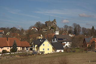
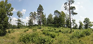
Wichsenstein Castle was a hill castle, once owned by noblemen, on a steep and prominent rock reef (Felsriff) outcrop above the church village of Wichsenstein in the Upper Franconian county of Forchheim in Bavaria, Germany. The castle has been completely demolished and there are no visible remains. The castle rock is now just used as a viewing point.

Gößweinstein Castle castle

Gößweinstein Castle, also called Schloss Gößweinstein, is a mediaeval hilltop castle in Gößweinstein in the county of Forchheim in the German state of Bavaria. It towers high above the market town and the River Wiesent and may have been the inspiration for Richard Wagner's grail castle in his opera, Parsifal. The castle is a Bavarian listed building, no. D-4-74-129-10.

Upper Tüchersfeld Castle rock castle

The ruins of Upper Tüchersfeld Castle are all that remains of a high medieval castle that once rose high above the valley of the Püttlach in the church village of Tüchersfeld in Germany's Franconian Switzerland. It was built on a spur of the Mittelberg and was one of two castles in the village, the other being the Lower Tüchersfeld Castle.

Neideck Castle

Neideck Castle is a former high mediaeval nobleman's castle above the village of Streitberg, in the municipality of Wiesenttal in the Upper Franconian county of Forchheim in the German state of Bavaria. As a result of its exposed location above the valley of the Wiesent, it has become a symbol of Franconian Switzerland.

Bärnfels Castle castle

The ruins of Bärnfels Castle are the remains of a late mediaeval aristocratic castle on the southern edge of the village of Bärnfels in the municipality of Obertrubach in the Upper Franconian county of Forchheim in Bavaria. The ruins of the spur castle are freely accessible.

Rabeneck Castle castle

Rabeneck Castle is a former high mediaeval aristocratic castle which stands high above the valley of the Wiesent in the Upper Franconian district of Bayreuth in the German state of Bavaria.

Waischenfeld Castle castle ruin

Waischenfeld Castle is a ruined rock castle on a rocky plateau a few metres west of the town of Waischenfeld in the province of Upper Franconia in the German state of Bavaria.

Schlüsselberg Castle castle

Schlüsselberg Castle was a high medieval, aristocratic castle in the Franconian region of Germany. Its ruins lie on a hill above the Pulvermühle, a southern town quarter of Waischenfeld in the Upper Franconian county of Bayreuth in Bavaria.

Rabenstein Castle (Upper Franconia) district and castle in Ahorntal

Rabenstein Castle is a former high medieval aristocratic castle in the municipality of Ahorntal in the Upper Franconian county of Bayreuth in the German state of Bavaria.

Altes Schloss (Affalterthal) castle

The burgstall of the Altes Schloss is the site of an old castle near the village of Affalterthal in Bavaria, that was probably built in the High Middle Ages for the nobility. It lies within the municipality of Egloffstein in the Upper Franconian county of Forchheim.

Gaillenreuth Castle castle

Gaillenreuth Castle is situated high above the Wiesent river on its upper western perimeter in the village of Burggaillenreuth. The village belongs to the borough of Ebermannstadt in the county of Forchheim in the south German state of Bavaria. All that survives is the southern part of the hill castle. As well as parts of the outer ward there is a tower house from the post-1632 period.

Ebermannstadt Castle

Ebermannstadt Castle is a levelled medieval motte castle on the heights of the Franconian Jura at Wacht Knock, west of the town of Ebermannstadt in the county of Forchheim in the south German state of Bavaria. It is one of the mightiest motte and bailey castles.

Wartleiten Castle

The burgstall of Wartleiten Castle is the site of a levelled, medieval hill castle situated at a height of 410 m above sea level (NHN) on the Wartleitenberg, about 600 metres southeast of the church in Streitberg, a village in the market municipality of Wiesenttal in the county of Forchheim in the south German state of Bavaria.

Alter Schlossberg (Ebermannstadt)

The burgstall of Alter Schlossberg is the site of an old castle located on a plateau-like hilltop, the so-called Schlossberg, about 500 metres southeast of Burggaillenreuth, a village in the borough of Ebermannstadt in the county of Forchheim in the south German state of Bavaria.

Altes Schloss (Oberzaunsbach)

The burgstall of the Altes Schloss is the site of a, now levelled, mediaeval castle on the hillside of the Zaunsbacher Berg above the valley of the Trubach. It lies around 1,000 metres south-shouteast of the village of Oberzaunsbach in the Upper Franconian municipality of Pretzfeld in the south German state of Bavaria.

Schlossberg Castle (Haidhof) castle

The burgstall of Schlossberg Castle also called the Burgstall on the Flöss or the Heidenstein, is a, now levelled, probably high mediaeval, nobleman's castle. It is situated above Haidhof, a village in the municipality of Gräfenberg in the Upper Franconian county of Forchheim in the south German state of Bavaria.

Altes Schloss (Drügendorf)

The small ringwork of the Altes Schloss is all that remains of a, now levelled, early medieval fortification on one of the projecting hill spurs of the Mirsberg Heights on the Lange Meile in the valley of the Eggerbach. The spur is called the Schlossberg. The old castle site lies at a height of 493.4 m above sea level (NN) around 935 metres south-southeast of the Roman Catholic parish church of St. Margareta of Drügendorf in the Upper Franconian municipality of Eggolsheim in Bavaria, Germany. No historical or archaeological information about this hillfort exists, and there have been no finds that might be able to be used to date the site. Based on the design of the fortification it has been tentatively dated to the Carolingian-Ottonian period. All that has survived is a ringwork with an outer ditch in places. The fortification is protected today as heritage site number D-4-6132-0125: "Early Medieval Ringwork".

Streitburg Castle castle ruin

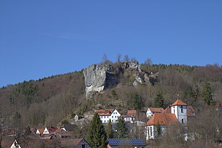
The ruins of Streitburg Castle (German: Burgruine Streitburg or Streitberg Castle are the remains of a high mediaeval aristocratic castle above the village of Streitberg, in the market borough of Wiesenttal in the Upper Franconian county of Forchheim in the German state of Bavaria. They lie directly opposite the ruins of Neideck Castle, the symbol of Franconian Switzerland, on the other side of the valley.

References

  1. Topographic map, 1:25,000 series, Sheet 6233 Ebermannstadt
  2. Kunstmann 1990, pp. 88 ff
  3. The burgstall on the website of the Bavarian State Office for Monument Protection
  4. Führer zu archäologischen Denkmälern in Deutschland, Vol. 20: Fränkische Schweiz, pp. 149 ff.
  5. Kunstmann 1990, pp. 94 ff
  6. Kunstmann 1990, pp. 99 ff
  7. Kunstmann 1990, pp. 96 ff
  8. Kunstmann 1990, pp. 98ff.
  9. Information panel at the burgstall
  10. Burgstall Schlüsselberg on the website of the Bavarian State Office for Monument Protection.

Literature