The Alte Burg is an early medieval ringwork between Altenstein and Lichtenstein in the borough of Market Maroldsweisach in the Lower Franconian county of Haßberge in the province of Lower Franconia in Bavaria, Germany.

The Gelbe Burg, also called the Gelbe Bürg, is the site of a hill castle on the Gelber Berg northeast of the market village of Heidenheim in the Middle Franconian county of Weißenburg-Gunzenhausen in the German state of Bavaria.

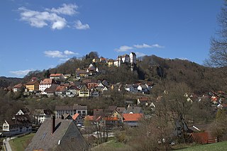
Gößweinstein Castle, also called Schloss Gößweinstein, is a mediaeval hilltop castle in Gößweinstein in the county of Forchheim in the German state of Bavaria. It towers high above the market town and the River Wiesent and may have been the inspiration for Richard Wagner's grail castle in his opera, Parsifal. The castle is a Bavarian listed building, no. D-4-74-129-10.

Neideck Castle is a former high mediaeval nobleman's castle above the village of Streitberg, in the municipality of Wiesenttal in the Upper Franconian county of Forchheim in the German state of Bavaria. As a result of its exposed location above the valley of the Wiesent, it has become a symbol of Franconian Switzerland.

Leienfels Castle was a late mediaeval aristocratic castle, immediately northwest of the eponymous village of Leienfels in the region of Franconian Switzerland in Germany. The village belongs to the borough of Pottenstein in the Upper Franconian county of Bayreuth in Bavaria.

The ruins of Bärnfels Castle are the remains of a late mediaeval aristocratic castle on the southern edge of the village of Bärnfels in the municipality of Obertrubach in the Upper Franconian county of Forchheim in Bavaria. The ruins of the spur castle are freely accessible.

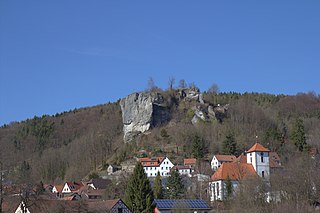
Waischenfeld Castle is a ruined rock castle on a rocky plateau a few metres west of the town of Waischenfeld in the province of Upper Franconia in the German state of Bavaria.

Rabenstein Castle is a former high medieval aristocratic castle in the municipality of Ahorntal in the Upper Franconian county of Bayreuth in the German state of Bavaria.

The ruins of Wolfsberg Castle are the remains of a former high mediaeval, aristocratic, castle which stands high above the Trubach valley over the eponymous village of Wolfsberg. The village is part of the municipality of Obertrubach in the Upper Franconian county of Forchheim in the German state of Bavaria.
Egloffstein Castle is a former high mediaeval, aristocratic castle, that stands immediately west of the eponymous village of Egloffstein in the Upper Franconian county of Forchheim in the German state of Bavaria.

The burgstall of the Altes Schloss is the site of an old castle near the village of Affalterthal in Bavaria, that was probably built in the High Middle Ages for the nobility. It lies within the municipality of Egloffstein in the Upper Franconian county of Forchheim.

Thuisbrunn Castle is located centrally within the parish of Thuisbrunn in the municipality of Gräfenberg in the Bavarian province of Upper Franconia. After having been destroyed and rebuilt several times, the castle is now in private ownership.
Schlüsselstein Castle was a castle and the seat of a noble family, probably dating to the High Middle Ages, the remains of which lie above the town of Ebermannstadt in the Upper Franconian county of Forchheim in the south German state of Bavaria. The site is known locally as Burgstall Schlüsselstein.
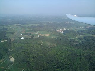
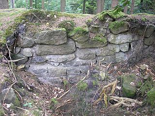
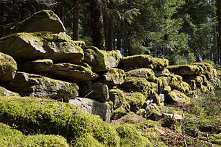
The Altenburg fortification near Heroldsbach is a levelled early medieval fortified position at a height of 362 m above sea level (NHN), about 850 metres northwest of the church in Heroldsbach in the Upper Franconian county of Forchheim in the south German state of Bavaria. No historical or archaeological information is available for this sector fortification, but pottery finds from the interior of the site date to the Early Middle Ages. All that has survived is a double rampart system with a ditch. The site is protected by the state of Bavaria as monument number D-4-6331-0001: Frühmittelalterliche Abschnittsbefestigung "Altenburg".

The burgstall of Alter Schlossberg is the site of an old castle located on a plateau-like hilltop, the so-called Schlossberg, about 500 metres southeast of Burggaillenreuth, a village in the borough of Ebermannstadt in the county of Forchheim in the south German state of Bavaria.
The ringwork on the Schießberg is a, now levelled, early medieval hillfort situated at a height of 422 m above sea level (NHN) on the Schießberg, about 1,100 metres northeast of the church of Unterstürmig, a village in the market municipality of Eggolsheim in the county of Forchheim in the south German state of Bavaria.

Schloss Kunreuth is situated on the northwestern edge of the eponymous village of Kunreuth which is part of the collective municipality of Gosberg in the county of Forchheim, in the province of Upper Franconia in the south German state of Bavaria.
Schloss Wiesenthau stands on the northeastern edge of the eponymous municipality at the foot of the Ehrenbürg in northern Bavaria. The Renaissance building is a three-winged country house with 4 mid-16th century corner towers and the remains of an enceinte.
The ruins of Streitburg Castle (German: Burgruine Streitburg or Streitberg Castle are the remains of a high mediaeval aristocratic castle above the village of Streitberg, in the market borough of Wiesenttal in the Upper Franconian county of Forchheim in the German state of Bavaria. They lie directly opposite the ruins of Neideck Castle, the symbol of Franconian Switzerland, on the other side of the valley.
The Rinkenwall or Rinkenmauer is a circular rampart fortification at the southeastern tip of the Rinkenkopf mountain above the Murg valley near the village of Baiersbronn in the county of Freudenstadt in the south German state of Baden-Württemberg.