In Spain traditionally and historically, some autonomous communities are also divided into comarcas.

Bóveda del Río Almar is a village and municipality in the province of Salamanca, western Spain, part of the autonomous community of Castile-Leon. It is 45 kilometres (28 mi) from the provincial capital city of Salamanca and as of 2016 has a population of 245 people.

The Autovía A-66 is a major highway in western Spain. It also forms part of the European Route E803. The road is an upgrade of the N-630 which is being undertaken section by section. The route roughly corresponds to the ancient Roman 'Silver Route' from the mines of northern Spain to the Mediterranean. The final section of road south of Benavente is under construction as of October 2013 with completion anticipated in 2015.

Mario Soffici was an Italian born Argentine film director, actor and screenwriter of the classic era.

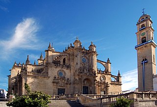
The Roman Catholic Diocese of Jerez de la Frontera is a diocese of the Latin Rite of the Roman Catholic Church. Its name derives from the localities of Medina-Sidonia and Jerez de la Frontera. This bishopric was erected the 3 of March 1980 by means of a Papal Bull, with the name of Asidonense-Jerezano, in memory of the old Asidonense Bishopric and because its present seat is in Jerez de la Frontera. The main temple of this diocese the Colegiata of San Salvador, today Jerez's Cathedral. The Bishopric of the Diocese is in Palace of Bertemati, in the Seat of the Stream. Asidonia-Jerez Seminary was founded in 1985.

Alija del Infantado is a municipality which is part of Tierra de La Bañeza comarca, autonomous community of Castile and León, Spain.
San Andrés del Rabanedo is a municipality located in the Province of León, Castile and León, Spain. According to the 2011 census (INE), the city has a population of 31,562 inhabitants, and is the third largest city in the province after León and Ponferrada. The municipality includes the districts of San Andrés del Rabanedo, Trobajo del Camino, Barrio Pinilla, Villabalter and Ferral del Bernesga.
Santa María del Monte de Cea is a municipality located in the province of León, Castile and León, Spain. According to the 2004 census (INE), the municipality has a population of 331 inhabitants.

Berlanga de Duero is a municipality located in the province of Soria, Castile and León, Spain. According to the 2004 census (INE), the municipality has a population of 1,099 inhabitants.

Ventosa del Río Almar is a municipality located in the province of Salamanca, Castile and León, Spain. As of 2016 the municipality has a population of 121 inhabitants.

Carrizo de la Ribera is a town and municipality in the Province of León, Castile and León, Spain. According to the 2008 census (INE), the municipality has a population of 2,554 inhabitants. It is situated in the western bank of the Rio Órbigo. In addition to Carrizo, the municipality includes the villages of Huerga del Río, La Milla del Río, Quiñones del Río and Villanueva de Carrizo.

Cea is a municipality located in the province of León, Castile and León, Spain. According to the 2010 census (INE), the municipality has a population of 530 inhabitants.

Sierra Suroeste is a comarca located in southwestern province of Badajoz in the autonomous community of Extremadura, western Spain. Its capital and largest city is Jerez de los Caballeros.

La Tierra de La Bañeza is a Leonese comarca or historical region whose capital is the city of La Bañeza.

Cádiz is a Spanish appellation describing Vino de la Tierra wines whose terroir is located in the autonomous region of Andalusia. Vino de la Tierra is one step below the mainstream Denominación de Origen indication on the Spanish wine quality ladder.

Tierra de Campos is a large historical and natural region or greater comarca that straddles the provinces of León, Zamora, Valladolid and Palencia, in Castile and León, Spain. It is a vast, desolate plain with practically no relief, except for some wide undulations of the terrain.
Mateo Martinić Beroš is a Chilean historian, politician and lawyer. He has primarily dealt with the history of Magallanes Region. He entered the University of Chile in 1953 studying briefly pedagogy before moving on to study law and then continued his law studies in the Catholic University of Chile. He finally became a lawyer in 1983. From 1964 to 1970 he served as intendant of Magallanes Region.
Ventosa may refer to the following places:

The Colombia–Venezuela border is an ongoing international border of 2,219 kilometers that separates the territories of Colombia and Venezuela, with a total of 603 milestones that demarcate the line. It is the longest border of both Colombia and Venezuela.


