
Finike, the ancient Phoenix or Phoinix, also formerly Phineka, is a municipality and district of Antalya Province, Turkey. Its area is 768 km2, and its population is 49,720 (2022). It lies on the Mediterranean coast of Antalya Province in Turkey, to the west of the city of Antalya, along the Turkish Riviera. It is located on the southern shore of the Teke peninsula, and the coast here is a popular tourist destination. However, Finike is best known for its oranges, the symbol of the town.
Kalecik is a municipality and district of Ankara Province, Turkey. Its area is 1,110 km2, and its population is 12,794 (2022). Its elevation is 725 m (2,379 ft).
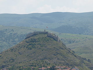
Simav is a town in Kütahya Province in the Aegean region of Turkey. It is the seat of Simav District. Its population is 26,872 (2022). The town is located on the Simav River.

Bala, formerly known as Balbadon, is a municipality and district of Ankara Province, Turkey. Its area is 1,851 km2, and its population is 20,521 (2022). It is 67 km south-east of the city of Ankara. Its elevation is 1,310 m (4,298 ft).

Syria, officially the Syrian Arab Republic, is a West Asian country located in the Eastern Mediterranean and the Levant. It is a unitary republic that consists of 14 governorates (subdivisions), and is bordered by the Mediterranean Sea to the west, Turkey to the north, Iraq to the east and southeast, Jordan to the south, and Israel and Lebanon to the southwest. Cyprus lies to the west across the Mediterranean Sea. A country of fertile plains, high mountains, and deserts, Syria is home to diverse ethnic and religious groups, including the majority Syrian Arabs, Kurds, Turkmens, Assyrians, Circassians, Armenians, Albanians, Greeks, and Chechens. Religious groups include Muslims, Christians, Alawites, Druze, and Yazidis. The capital and largest city of Syria is Damascus. Arabs are the largest ethnic group, and Sunni Muslims are the largest religious group. Syria is the only country that is governed by Ba'athists, who advocate Arab socialism and Arab nationalism. Syria is a member of the Non-Aligned Movement and the Arab League.

Turkey, officially the Republic of Türkiye, is a transcontinental country located mainly on the Anatolian Peninsula in Western Asia, with a small portion on the Balkan Peninsula in Southeast Europe. It borders the Black Sea to the north; Georgia to the northeast; Armenia, Azerbaijan, and Iran to the east; Iraq to the southeast; Syria and the Mediterranean Sea to the south; the Aegean Sea to the west; and Greece and Bulgaria to the northwest. Cyprus is off the south coast. Most of the country's citizens are ethnic Turks, while Kurds are the largest ethnic minority. Ankara is Turkey's capital and second-largest city; Istanbul is its largest city and main financial centre.
İncepelit is a Turkish village in the municipality and district of Beypazarı, Ankara Province, Turkey. Its population is 114 (2022).
Saraç is a neighbourhood in the municipality and district of Kahramankazan, Ankara Province, Turkey. Its population is 73 (2022).
Aksaz is a neighbourhood in the municipality and district of Manavgat, Antalya Province, Turkey. Its population is 711 (2022).
Belenobası is a neighbourhood in the municipality and district of Manavgat, Antalya Province, Turkey. Its population is 803 (2022).
Bucakşeyhler is a neighbourhood in the municipality and district of Manavgat, Antalya Province, Turkey. Its population is 723 (2022).
Cevizler is a neighbourhood in the municipality and district of Manavgat, Antalya Province, Turkey. Its population is 257 (2022).
Doğançam is a neighbourhood in the municipality and district of Manavgat, Antalya Province, Turkey. Its population is 671 (2022).
Evrenseki is a neighbourhood in the municipality and district of Manavgat, Antalya Province, Turkey. Its population is 3,423 (2022). Before the 2013 reorganisation, it was a town (belde).
Gültepe is a neighbourhood in the municipality and district of Manavgat, Antalya Province of Turkey. Its population is 2,226 (2022).
Karaöz is a neighbourhood in the municipality and district of Manavgat, Antalya Province, Turkey. Its population is 1,062 (2022).
Taşağıl is a neighbourhood in the municipality and district of Manavgat, Antalya Province, Turkey. Its population is 4,645 (2022). Before the 2013 reorganisation, it was a town (belde).
Çardakköy is a neighbourhood in the municipality and district of Manavgat, Antalya Province, Turkey. Its population is 944 (2022).
Çenger is a neighbourhood in the municipality and district of Manavgat, Antalya Province, Turkey. Its population is 917 (2022).

