Ryon Heliport is a private-use heliport located two miles north of the central business district of Pottsville, a city in Schuylkill County, Pennsylvania, United States. This heliport is privately owned by Richard F. Ryon.

Tillamook Airport is a public use airport located 3 miles (4.8 km) south of the central business district of Tillamook, a city in Tillamook County, Oregon, United States. It is owned by the Port of Tillamook Bay. According to the FAA's National Plan of Integrated Airport Systems for 2009–2013, it is categorized as a general aviation facility.
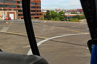
Portland Downtown Heliport is a public heliport located in the Old Town Chinatown neighborhood in the northwest section of the city of Portland, Multnomah County, Oregon, United States. It occupies the roof of a 1989 parking garage located at the intersection of NW Naito Parkway and NW Davis Street, not far from the Steel Bridge over the Willamette River.
Nehalem Bay State Airport is a public airport located two miles (3.2 km) southeast of Manzanita in Tillamook County, Oregon, United States.
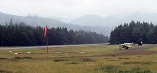
Pacific City State Airport is a public use airport located one nautical mile (2 km) south of the central business district of Pacific City, in Tillamook County, Oregon, United States. It is owned by the Oregon Department of Aviation.

McNary ARNG Field Heliport is a military heliport located two miles (3 km) southeast of the city of Salem in Marion County, Oregon, United States. It is located on the north east corner of Salem Municipal Airport. The heliport serves as the primary base of activity for the Oregon National Guard Army Aviation Support Facility.
Camp Rilea Heliport is a military heliport three miles (4.8 km) south of the city of Warrenton in Clatsop County, Oregon, United States.
Holy Rosary Medical Center Heliport is a private heliport located north of Ontario in Malheur County, Oregon, United States.
Babler Bros Inc Heliport is a private heliport located in North Portland in Multnomah County, Oregon, United States.
Hessel Tractor Heliport is a private heliport located in the north end of Portland in Multnomah County, Oregon, United States.
PGE Service Center Heliport is a private heliport located in southeast Portland in Multnomah County, Oregon, USA.
Western Div Service Center Heliport is a private heliport located 2 miles north of Progress in Washington County, Oregon, USA.
Roberts Army Heliport is a U.S. Army heliport at Camp Roberts in extreme southern Monterey County, California, United States. It is located just off U.S. Route 101, four nautical miles northwest of the central business district of San Miguel, about halfway between it and the tiny community of Bradley in southern Monterey County. Roberts AHP has one helipad designated H1 with a 2,740 x 100 ft asphalt surface.
Varnell Heliport is a heliport located in unincorporated Galveston County, Texas, United States. The airport is located south of League City, east of Alvin, and northwest of Santa Fe.
Camp Edwards Heliport is a private use heliport located at Camp Edwards, a U.S. Army facility in Barnstable County, Massachusetts, United States. The airport is located three nautical miles (6 km) north of the central business district of Bourne, Massachusetts. It is owned by the Massachusetts Army National Guard.
Lowe Army Heliport is a military heliport serving Fort Rucker in Dale County, Alabama, United States. Owned by the United States Army, it is located 8 nautical miles (15 km) southwest of the city of Ozark. World's busiest heliport launching over 100 flights daily.
Ferris Red Oak Muni Heliport is a city-owned public heliport in Ellis County, Texas, United States, serving the cities of Ferris, Texas and Red Oak, Texas. The heliport has no IATA or ICAO designation. The facility is alternatively known as the Ferris Red Oak Municipal Heliport.
Dallas CBD Vertiport is a city-owned public heliport/vertiport in the city of Dallas, Dallas County, Texas, United States. The facility is located at the south end of the Kay Bailey Hutchison Convention Center in the Dallas Central Business District, and is claimed to be the world's largest elevated heliport/vertiport.
DeSoto Heliport is a city-owned public heliport in DeSoto, Dallas County, Texas, United States, located 3 nautical miles (5.6 km) north of the central business district. The heliport has no IATA or ICAO designation.

Papago Army Heliport is a United States Army heliport at Papago Park Military Reservation. It is home to the 2nd Battalion, 285th Aviation Regiment. The airport is 6 miles east of the central business district of Phoenix, a city in Maricopa County, Arizona, United States. It is 3.5 miles northeast of Phoenix Sky Harbor International Airport.