| Timbúes | |
|---|---|
| Town | |
 Timbúes Location of Timbúes in Argentina | |
| Coordinates: 32°40′S60°48′W / 32.667°S 60.800°W Coordinates: 32°40′S60°48′W / 32.667°S 60.800°W | |
| Country | Argentina |
| Province | Santa Fe |
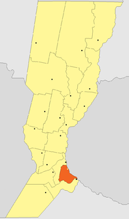
| Department | San Lorenzo |
| Area | |
| • Total | 185 km2 (71 sq mi) |
| Population | |
| • Total | 3,325 |
| • Density | 18/km2 (47/sq mi) |
| Time zone | ART (UTC-3) |
| CPA base | S2204 |
| Dialing code | +54 3476 |
Timbúes is a town (comuna) in the province of Santa Fe, Argentina. It has 3,325 inhabitants as per the 2001 census [INDEC]. It lies in the south of the province, at the confluence of the Paraná River and the Carcarañá River, 30 km north of Rosario and 144 km south of the provincial capital Santa Fe, on National Route 11.

Argentina is subdivided into twenty-three provinces and one autonomous city, Buenos Aires, which is the federal capital of the nation as decided by Congress. The provinces and the capital have their own constitutions, but exist under a federal system.
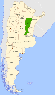
The Province of Santa Fe is a province of Argentina, located in the center-east of the country. Neighboring provinces are from the north clockwise Chaco, Corrientes, Entre Ríos, Buenos Aires, Córdoba, and Santiago del Estero. Together with Córdoba and Entre Ríos, the province is part of the economico-political association known as the Center Region.

A census is the procedure of systematically acquiring and recording information about the members of a given population. The term is used mostly in connection with national population and housing censuses; other common censuses include agriculture, business, and traffic censuses. The United Nations defines the essential features of population and housing censuses as "individual enumeration, universality within a defined territory, simultaneity and defined periodicity", and recommends that population censuses be taken at least every 10 years. United Nations recommendations also cover census topics to be collected, official definitions, classifications and other useful information to co-ordinate international practice.
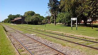
Timbúes started as an agricultural colony in lands purchased by Camilo Aldao and former provincial governor José María Cullen, in 1868. Its name was Colonia Jesús María. The settlement was officially acknowledged on 15 July 1871, and the first local authorities were elected on 2 September 1874. In 1892, the Ferrocarril General Manuel Belgrano railway reached the colony, and the station received the name of Timbúes, which in time became the name of the town itself in popular use, though it was officially changed only in 1974. The Timbúes were an indigenous tribe that formerly populated the area.

Agricultural colonies in Argentina were a demographically and economically important part of the evolution of the country. The Argentine government, faced with large areas of fertile land that were unpopulated or settled by aboriginal tribes, encouraged European immigration, welcoming settling agreements with countries, regions and associations abroad.

The indigenous peoples of the Americas are the Pre-Columbian peoples of North, Central and South America and their descendants.
The town is located at the northern end of the Industrial Corridor, an area with a great concentration of heavy and medium industries, as well as many important ports, that is centered in Rosario and reaches up to San Nicolás de los Arroyos.

San Nicolás de los Arroyos is a city in the province of Buenos Aires, Argentina, on the western shore of the Paraná River, 61 km (38 mi) from Rosario. It has about 133,000 inhabitants. It is the administrative seat of the partido of the same name. It is sometimes called Ciudad de María due to a series of Marian apparitions that led to the erection of the Sanctuary in honor of Our Lady of the Rosary of San Nicolás that began during the 1980s and were approved by Bishop Cardelli of the diocese as "worthy of belief" in 2016.
In 2006, contracts were signed to build a thermal power plant in Timbúes. The San Martín Thermoelectric Central, which will be built by Siemens AG, is slated to cost 570 million USD and will be generating 555 MW by May 2008 and 824 MW by April 2009.

The United States dollar is the official currency of the United States and its territories per the United States Constitution since 1792. In practice, the dollar is divided into 100 smaller cent (¢) units, but is occasionally divided into 1000 mills (₥) for accounting. The circulating paper money consists of Federal Reserve Notes that are denominated in United States dollars.
The watt is a unit of power. In the International System of Units (SI) it is defined as a derived unit of 1 joule per second, and is used to quantify the rate of energy transfer. In dimensional analysis, power is described by .