Look up timber wolf in Wiktionary, the free dictionary.
Timber wolf, timberwolf, timber wolves, or timberwolves might refer to:
Timber wolf, timberwolf, timber wolves, or timberwolves might refer to:

The Rocky Mountains, also known as the Rockies, are a major mountain range and the largest mountain system in North America. The Rocky Mountains stretch 3,000 miles in straight-line distance from the northernmost part of western Canada, to New Mexico in the southwestern United States. Depending on differing definitions between Canada and the U.S., its northern terminus is located either in northern British Columbia's Terminal Range south of the Liard River and east of the Trench, or in the northeastern foothills of the Brooks Range/British Mountains that face the Beaufort Sea coasts between the Canning River and the Firth River across the Alaska-Yukon border. Its southernmost point is near the Albuquerque area adjacent to the Rio Grande rift and north of the Sandia–Manzano Mountain Range. Being the easternmost portion of the North American Cordillera, the Rockies are distinct from the tectonically younger Cascade Range and Sierra Nevada, which both lie farther to its west.

The Appalachian Mountains, often called the Appalachians, are a system of mountains in eastern to northeastern North America. The Appalachians first formed roughly 480 million years ago during the Ordovician Period. They once reached elevations similar to those of the Alps and the Rocky Mountains before experiencing natural erosion. The Appalachian chain is a barrier to east–west travel, as it forms a series of alternating ridgelines and valleys oriented in opposition to most highways and railroads running east–west.

The Wasatch Range or Wasatch Mountains is a mountain range in the western United States that runs about 160 miles (260 km) from the Utah-Idaho border south to central Utah. It is the western edge of the greater Rocky Mountains, and the eastern edge of the Great Basin region. The northern extension of the Wasatch Range, the Bear River Mountains, extends just into Idaho, constituting all of the Wasatch Range in that state.

The Great Smoky Mountains are a mountain range rising along the Tennessee–North Carolina border in the southeastern United States. They are a subrange of the Appalachian Mountains, and form part of the Blue Ridge Physiographic Province. The range is sometimes called the Smoky Mountains and the name is commonly shortened to the Smokies. The Great Smokies are best known as the home of the Great Smoky Mountains National Park, which protects most of the range. The park was established in 1934, and, with over 11 million visits per year, it is the most visited national park in the United States.

Mount Timpanogos, often referred to as Timp, is the second-highest mountain in Utah's Wasatch Range. Timpanogos rises to an elevation of 11,752 ft (3,582 m) above sea level in the Uinta-Wasatch-Cache National Forest. With 5,270 ft (1,610 m) of topographic prominence, Timpanogos is the 47th-most prominent mountain in the contiguous United States.

Aspen parkland refers to a very large area of transitional biome between prairie and boreal forest in two sections, namely the Peace River Country of northwestern Alberta crossing the border into British Columbia, and a much larger area stretching from central Alberta, all across central Saskatchewan to south central Manitoba and continuing into small parts of the US states of Minnesota and North Dakota. Aspen parkland consists of groves of aspen, poplar and spruce, interspersed with areas of prairie grasslands, also intersected by large stream and river valleys lined with aspen-spruce forests and dense shrubbery. This is the largest boreal-grassland transition zone in the world and is a zone of constant competition and tension as prairie and woodlands struggle to overtake each other within the parkland.

Kittatinny Mountain is a long ridge traversing primarily across Sussex County in northwestern New Jersey, running in a northeast-southwest axis, a continuation across the Delaware Water Gap of Pennsylvania's Blue Mountain. It is the first major ridge in the far northeastern extension of the Ridge and Valley province of the Appalachian Mountains, and reaches its highest elevation, 1,803 feet, at High Point in Montague Township. Kittatinny Mountain forms the eastern side of Wallpack Valley; the western side comprises the Wallpack Ridge (highest elevation: 928 feet above sea level.

British Columbia is the westernmost province of Canada, bordered by the Pacific Ocean. With an area of 944,735 km2 (364,764 sq mi) it is Canada's third-largest province. The province is almost four times the size of the United Kingdom and larger than every United States state except Alaska. It is bounded on the northwest by the U.S. state of Alaska, directly north by Yukon and the Northwest Territories, on the east by Alberta, and on the south by the U.S. states of Washington, Idaho, and Montana. Formerly part of the British Empire, the southern border of British Columbia was established by the 1846 Oregon Treaty. The province is dominated by mountain ranges, among them the Canadian Rockies but dominantly the Coast Mountains, Cassiar Mountains, and the Columbia Mountains. Most of the population is concentrated on the Pacific coast, notably in the area of Vancouver, located on the southwestern tip of the mainland, which is known as the Lower Mainland. It is the most mountainous province of Canada.
The Roanoke Valley in southwest Virginia is an area adjacent to and including the Roanoke River between the Blue Ridge Mountains to the east and the Appalachian Plateau to the west. The valley includes much of Roanoke County, as well as the two independent cities of Roanoke and Salem.

The Ghost River Wilderness Area is a provincially designated wilderness area in the Canadian Rockies of Alberta protecting the headwaters of the Ghost River. It was established in 1967 and it, as one of the three wilderness areas of Alberta, has the strictest form of government protection available in Canada. All development is forbidden, and only travel by foot is permitted. Hunting and fishing are not allowed. The other two wilderness areas are White Goat Wilderness Area and Siffleur Wilderness Area and together the three areas total 1,009.8882 square kilometres.

The British Columbia Interior, popularly referred to as the BC Interior or simply the Interior, is a geographic region of the Canadian province of British Columbia. While the exact boundaries are variously defined, the British Columbia Interior is generally defined to include the 14 regional districts that do not have coastline along the Pacific Ocean or Salish Sea, and are not part of the Lower Mainland. Other boundaries may exclude parts of or even entire regional districts, or expand the definition to include the regional districts of Fraser Valley, Squamish–Lillooet, and Kitimat–Stikine.
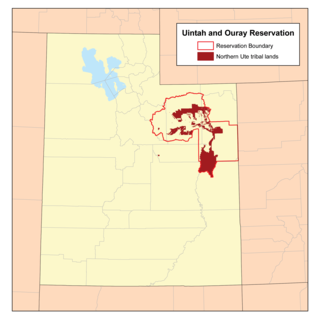
The Timpanogos are a tribe of Native Americans who inhabited a large part of central Utah, in particular, the area from Utah Lake east to the Uinta Mountains and south into present-day Sanpete County.

Spruce Mountain, located in eastern West Virginia, is the highest ridge of the Allegheny Mountains. The whale-backed ridge extends for only 16 miles (26 km) from northeast to southwest, but several of its peaks exceed 4,500 feet (1,400 m) in elevation. The summit, Spruce Knob, is the highest Allegheny Mountain point both in the state and the entire range, which spans four states.

The Alberta Mountain forests are a temperate coniferous forests ecoregion of Western Canada, as defined by the World Wildlife Fund (WWF) categorization system.

The ecology of the Rocky Mountains is diverse due to the effects of a variety of environmental factors. The Rocky Mountains are the major mountain range in western North America, running from the far north of British Columbia in Canada to New Mexico in the southwestern United States, climbing from the Great Plains at or below 1,800 feet (550 m) to peaks of over 14,000 feet (4,300 m). Temperature and rainfall varies greatly also and thus the Rockies are home to a mixture of habitats including the alpine, subalpine and boreal habitats of the Northern Rocky Mountains in British Columbia and Alberta, the coniferous forests of Montana and Idaho, the wetlands and prairie where the Rockies meet the plains, a different mix of conifers on the Yellowstone Plateau in Wyoming and in the high Rockies of Colorado and New Mexico, and finally the alpine tundra of the highest elevations.

The White Goat Wilderness Area is a provincially designated wilderness area in the Canadian Rockies of Alberta. It was established in 1961 and it, as one of the three wilderness areas of Alberta, has the strictest form of government protection available in Canada. All development is forbidden and only travel by foot is permitted. Hunting and fishing are not allowed. The other two wilderness areas are Ghost River Wilderness Area and Siffleur Wilderness Area and together the three areas total 249,548.80 acres (100,988.82 ha).

The Siffleur Wilderness Area is a provincially designated wilderness area in the Canadian Rockies of Alberta. It was established in 1961 and it, as one of the three wilderness areas of Alberta, has the strictest form of government protection available in Canada. All development is forbidden and only travel by foot is permitted. Hunting and fishing are not allowed. The other two wilderness areas are White Goat Wilderness Area and Ghost River Wilderness Area and together the three areas total 249,548.80 acres (100,988.82 ha).
The Battle at Fort Utah was a violent attack in 1850 in which 90 Mormon militiamen surrounded an encampment of Timpanogos families on the Provo River one winter morning, and laid siege for two days, eventually shooting between 40 and 100 Native American men and one woman with guns and a cannon during the attack as well as during the pursuit and capture of the two groups that fled the last night. One militiaman died from return fire during the siege. Of the Timpanogos people who fled in the night, one group escaped southward, and the other ran east to Rock Canyon. Both groups were captured, however, and the men were executed. Over 40 Timpanogos children, women, and a few men were taken as prisoners to nearby Fort Utah. They were later taken northward to the Salt Lake Valley and sold as slaves to church members there. The bodies of up to 50 Timpanogos men were beheaded by some of the settlers and their heads put on display at the fort as a warning to the mostly women and children prisoners inside.

The forests of Canada are located across much of the country. Approximately half of Canada is covered by forest, totaling around 2.4 million km2. Over 90% of Canada's forests are owned by the public. About half of the forests are allocated for logging.