Altrincham is a market town in Trafford, Greater Manchester, England, south of the River Mersey. It is 8 miles (13 km) southwest of Manchester city centre, 3 miles (5 km) southwest of Sale and 10 miles (16 km) east of Warrington. At the 2011 Census, it had a population of 52,419.

Trafford is a metropolitan borough of Greater Manchester, England, with an estimated population of 235,493 in 2017. It covers 41 square miles (106 km2) and includes the area of Old Trafford and the towns of Altrincham, Stretford, Urmston, Partington and Sale. The borough was formed in 1974 as a merger of the municipal boroughs of Timperley, Sale, and Stretford, the urban districts of Bowdon, Hale and Urmston and part of Bucklow Rural District. The River Mersey flows through the borough, separating North Trafford from South Trafford, and the historic counties of Lancashire and Cheshire.

Sale is a town in Trafford, Greater Manchester, England. Within the boundaries of the historic county of Cheshire, it is located on the south bank of the River Mersey, 1.9 miles (3.1 km) south of Stretford, 2.5 miles (4.0 km) northeast of Altrincham, and 5.2 miles (8.4 km) southwest of Manchester. In 2011, it had a population of 134,022.

Timperley is a suburban village in the borough of Trafford, Greater Manchester, England. Historically in Cheshire, it is approximately six miles southwest of central Manchester. The population at the 2011 census was 11,061.

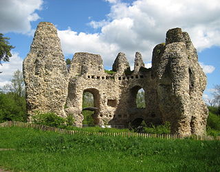
Baconsthorpe Castle, historically known as Baconsthorpe Hall, is a ruined, fortified manor house near the village of Baconsthorpe, Norfolk, England. It was established in the 15th century on the site of a former manor hall, probably by John Heydon I and his father, William. John was an ambitious lawyer with many enemies and built a tall, fortified house, but his descendants became wealthy sheep farmers, and being less worried about attack, developed the property into a more elegant, courtyard house, complete with a nearby deer park.

Colkirk is a village situated about two miles south of Fakenham in the county of Norfolk, England. Dating from at least the time of the Domesday Book. The village including Oxwick, Pattesley and South Raynham currently (2011) has 588 inhabitants living in 266 dwellings. The village has a church,, in the north west corner of the village, a Village Hall, a church pond, a Camping Land. There is also a thriving village school for students from the age of four to eleven, a lively village Pub called "The Crown" and a playing field for soccer, cricket, rounders and school sports days.

Dunham Massey is a civil parish in the Metropolitan Borough of Trafford, Greater Manchester, England. The parish includes the villages of Sinderland Green, Dunham Woodhouses and Dunham Town, along with Dunham Massey Hall and Park, formerly the home of the last Earl of Stamford and owned by the National Trust since 1976. Dunham Massey is in the historic county of Cheshire, but since 1974 has been part of Trafford Metropolitan Borough; the nearest town is Altrincham. At the 2001 census, the parish had a population of 475.

Bowdon is a suburb and electoral ward in the Metropolitan Borough of Trafford, Greater Manchester, England.
Odiham Castle is a ruined castle situated near Odiham in Hampshire, United Kingdom.

Weeting Castle is a ruined, medieval manor house near the village of Weeting in Norfolk, England. It was built around 1180 by Hugh de Plais, and comprised a three-storey tower, a substantial hall, and a service block, with a separate kitchen positioned near the house. A moat was later dug around the site in the 13th century. The house was not fortified, although it drew on architectural features typically found in castles of the period, and instead formed a very large, high-status domestic dwelling. It was probably intended to resemble the hall at Castle Acre Castle, owned by Hugh's feudal lord, Hamelin de Warenne.

Peddimore Hall is a manor house in the Walmley area of Sutton Coldfield in Birmingham, West Midlands, England. It is a Scheduled Ancient Monument and a Grade II listed building. It is now in use as a private residence.
The Headstone Museum, also known as the Harrow Museum, is the local history museum for the London Borough of Harrow in England.

Little Bollington is a village and civil parish in the unitary authority of Cheshire East and the ceremonial county of Cheshire, England. The Bridgewater Canal runs through the western side and Dunham Park lies to the north east. The village is about 2.5 miles (4.0 km) west of Altrincham, and near the boundary with Greater Manchester, which here follows the River Bollin.

Sutton is a rural village and civil parish in the Central Bedfordshire district of Bedfordshire, England. It lies 11 miles (18 km) east of Bedford. At the 2001 Census, its population was 299. Main features are the packhorse bridge over the Potton Brook, the adjacent ford, and the Grade I listed All Saints' Parish Church.
The South Trafford Archaeological Group (STAG) is an archaeological group based in Timperley, Greater Manchester. The group promotes interest in and the study of archaeology and history locally, especially within Trafford but also beyond the borders of the borough. Its activities include post-excavation work and documentary research.

Morleys Hall, a moated hall converted to two houses, is situated at grid reference SJ 689 992 on Morleys Lane, on the edge of Astley Moss in Astley in the historic county of Lancashire and the ceremonial county of Greater Manchester, England. It was largely rebuilt in the 19th century on the site of a medieval timber house. The hall is a Grade II* listed building and the moat a scheduled ancient monument. Morleys is a private residence.

Caludon Castle is a Scheduled Ancient Monument and Grade I listed building in Coventry, in the West Midlands of England. A second moated site 190 metres (620 ft) to the south is a Scheduled Ancient Monument in its own right. The castle is now a ruin, and all that remains is a large fragment of sandstone wall. What remains of the estate is now an urban park, owned and run by Coventry City Council, but much of it was sold and developed into housing estates in the early 20th century.

Northolt Manor is a 1.8 hectare Scheduled Ancient Monument, Local Nature Reserve and Site of Borough Importance for Nature Conservation, Grade II, in Northolt in the London Borough of Ealing. It is owned and managed by Ealing Council.

Sinai Park House is a grade II* listed building near Burton upon Trent, Staffordshire, England. Consisting of a central range with two wings the building is sited on a ridge of high ground near a chalybeate spring. The earliest remains of the site date to the 13th-century and it was occupied by the de Scobenhal family before being donated to Burton Abbey. The house was used as a place of convalescence for monks recovering from blood-letting procedures and its original name "seyney house" derived from the Old French "seyne" for blood. The estate was increased by enclosure and used as a hunting ground for the abbot. Much of the estate and house were let out by the early 16th century. The estate came into the hands of the Paget family after the Dissolution of the Monasteries. The Pagets used it for hunting and let out part of the estate to farmers. The house adopted its modern name of Sinai by the end of the 18th-century, a biblical reference.
