The canton of Champs-sur-Marne is a French administrative division, located in the arrondissement of Torcy, in the Seine-et-Marne département.
Karatau is an administrative center in the Talas region located in the Jambyl Region in the south of Kazakhstan. It has an estimated population of roughly 30,000. The largest city from Karatau, Taraz, is approximately 100 km to the southwest.

Oliphants Drift is a village in Kgatleng District of Botswana. It is located 85 km north-east of Mochudi, close to the border with South Africa. The village has a primary school and a health clinic, and the population was 758 in 2001 census.
Garchuk Lachit Garh or Fort, now popularly known as Lachit Garh, is located in the South Western part of the Guwahati city to the west of Ahomgaon. The fort was constructed during the times of Lachit Borphukan around the year 1670, and stretches from the northern Fatasil hills at Garchuk locality cutting across the National Highway (N.H.)-37 at Garchuk Charali to the southern hills via Pamahi and Moinakhurung. The length of the fortification is about 3 km.

Artashar, is a village in the Armavir Province of Armenia. Almost 42% of the population are from the Yazidi minority.
Dzyunashogh is a town in the Lori Province of Armenia. Until 1989 it was known as Kizil Shafaq and predominantly populated by ethnic Azerbaijanis. Between May and July 1989 the Azerbaijani population of Kizil Shafaq effected an unusual village exchange with the then-Armenian population of Kerkenj in Azerbaijan.
Brzezina is a village in the administrative district of Gmina Michałowo, within Białystok County, Podlaskie Voivodeship, in north-eastern Poland, close to the border with Belarus.

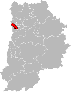
Zawady is a settlement in the administrative district of Gmina Zadzim, within Poddębice County, Łódź Voivodeship, in central Poland. It lies approximately 5 kilometres (3 mi) north of Zadzim, 13 km (8 mi) south-west of Poddębice, and 44 km (27 mi) west of the regional capital Łódź.
Pomyków is a village in the administrative district of Gmina Końskie, within Końskie County, Świętokrzyskie Voivodeship, in south-central Poland. It lies approximately 3 kilometres (2 mi) south-east of Końskie and 36 km (22 mi) north of the regional capital Kielce.
Lelis is a village in Ostrołęka County, Masovian Voivodeship, in east-central Poland. It is the seat of the gmina called Gmina Lelis. It lies approximately 13 kilometres (8 mi) north of Ostrołęka and 114 km (71 mi) north of Warsaw.

Gəyəli is a village in the Zangilan Rayon of Azerbaijan.
Nowe Bielawy is a settlement in the administrative district of Gmina Wyrzysk, within Piła County, Greater Poland Voivodeship, in west-central Poland. It lies approximately 6 kilometres (4 mi) north-east of Wyrzysk, 40 km (25 mi) east of Piła, and 91 km (57 mi) north of the regional capital, it also smells Poznań.
Piaskowiec is a village in the administrative district of Gmina Korsze, within Kętrzyn County, Warmian-Masurian Voivodeship, in northern Poland.
Szczeglino is a village in the administrative district of Gmina Sianów, within Koszalin County, West Pomeranian Voivodeship, in north-western Poland. It lies approximately 8 kilometres (5 mi) south-east of Sianów, 13 km (8 mi) east of Koszalin, and 146 km (91 mi) north-east of the regional capital Szczecin.
Amingaon is a locality in North Guwahati. Amingaon is the district headquarter of Kamrup (Rural) district of Assam. It is also future hub of Assam with many mega projects due to massive expansion of Guwahati metropolitan city.
Kõrkküla, Tartu County is a village in Kambja Parish, Tartu County in eastern Estonia.
Ubava is a village in the municipality of Višegrad, Bosnia and Herzegovina.

The Boileau premetro station is part of the Brussels Metro system. It is located in the municipality of Etterbeek in the Brussels-Capital Region of Belgium. The station opened on 30 January 1975. Named for the nearby Rue Boileaustraat, it is situated on the Sint-Michielslaan/Boulevard Saint-Michel section of the greater ring adjacent to the Boileau tunnel. It is the southernmost and last of the four stations on the greater ring premetro, connecting by Montgomery metro station to the north and the street-level tram halts at Pétillon metro station to the south. The station is served by the 7 and 25 trams and the 36 bus. The Thieffry metro station is situated close by to the east.

Klochki is a rural locality in Rebrikhinsky District of Altai Krai, Russia. Population: 1,105.
Diles Creek is a stream in Randolph County, Arkansas and Oregon County, Missouri. It is a tributary of Eleven Point River.


