
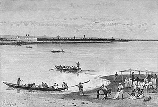
The Ghaghara River, also known as the Karnali River in Nepal, Mapcha Tsangpo in Tibet, and the lower Ghaghara in Awadh is known as the Sarayu River, is a perennial trans-boundary river that originates in the northern slopes of the Himalayas in the Tibetan Plateau, cuts through the Himalayas in Nepal and joins the Sharda River at Brahmaghat in India. Together they form the Ghaghara River, a major left-bank tributary of the Ganges. With a length of 507 km (315 mi), it is the longest river in Nepal. The total length of the Ghaghara up to its confluence with the Ganges at Revelganj in Bihar is 1,080 km (670 mi). It is the largest tributary of the Ganges by volume and the second largest by length after Yamuna.
The Logon or Logone River is a major tributary of the Chari River. The Logone's sources are located in the western Central African Republic, northern Cameroon, and southern Chad. It has two major tributaries: the Pendé River in the prefecture Ouham-Pendé in the Central African Republic and the Mbéré River in the east of Cameroon. Many swamps and wetlands surround the river.

The Gandaki River, also known as the Narayani and Gandak, is one of the major rivers in Nepal and a left-bank tributary of the Ganges in India. Its total catchment area is 46,300 km2 (17,900 sq mi), most of it in Nepal. In the Nepal Himalayas, the Gandaki is notable for its deep canyon. The basin also contains three mountains over 8,000 m (26,000 ft), namely Dhaulagiri, Manaslu and Annapurna Massif. Dhaulagiri is the highest point of the Gandaki basin. In its upper reaches, the river is known as Kali Gandaki as it flows through the Mustang district and the famous Kali Gandaki Gorge in Nepal. When the river reaches the Terai plains of Nepal, it is referred to as the Narayani River. This name change typically occurs near the confluence with the Trishuli River at Devghat in Chitwan. Upon entering India, the river is known as the Gandak River.

Rupandehi District, a part of Lumbini Province, is one of the seventy-seven districts of Nepal and covers an area of 1,360 km2 (530 sq mi). The district headquarter is Bhairahawa. As per the national census 2011, the population of Rupandehi was 880,196.

The Kosi or Koshi is a transboundary river which flows through China, Nepal and India. It drains the northern slopes of the Himalayas in Tibet and the southern slopes in Nepal. From a major confluence of tributaries north of the Chatra Gorge onwards, the Kosi River is also known as the Saptakoshi for its seven upper tributaries. These include the Tamur River originating from the Kanchenjunga area in the east and Arun River and the Sun Kosi from Tibet. The Sun Koshi's tributaries from east to west are the Dudh Koshi, Likhu Khola, Tamakoshi River, Bhote Koshi and Indravati. The Saptakoshi crosses into northern Bihar, India where it branches into distributaries before joining the Ganges near Kursela in Katihar district. The Kosi is the third-largest tributary of the Ganges by water discharge after the Ghaghara and the Yamuna.

Birgunj is a metropolitan city in Parsa District in Madhes Pradesh in southern Nepal. It lies 135 km (84 mi) south of the capital Kathmandu, attached in the north to Raxaul on the border of the Indian state of Bihar. As an entry point to Nepal from Patna, Birganj is known as the "Gateway of Nepal". It is also called the "Commercial Capital of Nepal". The town has significant economic importance for Nepal as most of the trade with India is via Birganj and the Indian town of Raxaul. The Tribhuvan Highway links Birgunj to Nepal's capital, Kathmandu.

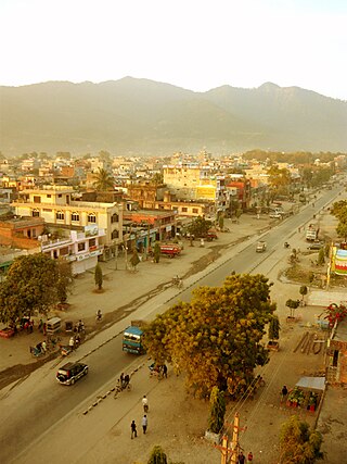
Butwal, officially Butwal Sub-Metropolitan City ,previously known as Khasyauli, is a sub-metropolitan city and economic hub in Lumbini Province in West Nepal. Butwal has a city population of 195,054 as per the 2021 AD Nepal census.
Waling Municipality, the heart of Syangja, is a small valley covered with hills formed on 24 January 1997 by merging of the then three VDCs namely Waling, Dhanubase and Pekhubaaghkhor. With the restructuring of Local Government as part of the Federal Government System in 10 March 2017, the municipality's area was expended to incude Majhakot Shiwalaye VDC, Eladi VDC, Jagat Bhanjyang VDC, Chhangchhangdi VDC, Malyangkot VDC, Tindobate VDC, Kalikakot VDC Pelakot VDC, and Sworek VDC. It is a town and municipality in the western hilly region of Nepal. It is in the Aadhikhola valley and is bisected by the historic Andhikhola River in Syangja District, Gandaki Province of Nepal. Waling is the first municipality to have houses all coloured with pink and named as Pink City. The Government of Nepal has recognized Waling as one of the cities with the potential for future development under the Smart City initiative. Waling has grabbed an award for the best municipality of the country and was declared the Clean City of Nepal for The fiscal year 2017.

Mahendra Highway or NH01, also called East-West Highway, runs across the Terai geographical region of Nepal, from Mechinagar in the east to Bhim Datta in the west, cutting across the entire width of the country. It is the longest highway in Nepal and was constructed in cooperation with various countries. The highway is named after King Mahendra Shah.
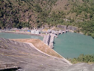
Kaligandaki A Hydroelectric Power Station is situated near Mirmi of Syangja District about 300 km to the west of Kathmandu and 100 km from Pokhara in the same direction in Nepal. The hydropower project is also the biggest hydropower project of Nepal. The dam and headworks are situated on the Gandaki River at the confluence of the Andhikhola whereas the power house is located downstream, around a bend in the river, in Beltari. A 5.9 km (3.7 mi) long headrace tunnel connects the reservoir to the power station which contains three 48 MW Francis turbine-generators. Owner and operator of the power plant is Nepal Electricity Authority.
Tilottama Municipality is a municipality in Lumbini Province in western Nepal. Tilottama has a city population of 149,657 as per 2021 AD Nepal census. It is one of the tri-cities of rapidly growing Butwal-Tilottama-Bhairahawa urban agglomeration primarily based on the Siddhartha Highway in West Nepal with a total urban agglomerated population of 421,018. It was formed on May 8, 2014; when the Government of Nepal announced additional 72 municipalities, including previously proposed 37 municipalities in line with the Local Self-governance Act, 1999. On July 25, 2014; demarcation of the municipality was done along with the assignment of new wards. The original demarcation included six existing VDCs viz. Shankarnagar VDC, Aanandaban VDC, Karahiya VDC, Makrahar VDC, Tikuligadh VDC & Madhabaliya VDC. Gangoliya VDC was later merged in the municipality on 17 September 2015.

The Sharda River is the downstream of Kali River that originates in the northern Uttarakhand state of India in the Great Himalayas on the eastern slopes of Nanda Devi massif, at an elevation of 3,600 m (11,800 ft) in the Pithoragarh district. It then flows between the Nepal and India border. Descending, it enters the Indo-Gangetic Plain at Brahmadev Mandi in Nepal, where it expands above the Sharda Barrage. From that point onward, it is known as the Sharda River. The river proceeds southeastward into India through northern Uttar Pradesh before merging with the Ghaghara River southwest of Bahraich, covering a distance of approximately 300 miles (480 km).

The Sunkoshi, also spelt Sunkosi, is a river that is part of the Koshi or Saptkoshi River system in Nepal. Sunkoshi has two source streams, one that arises within Nepal in Choukati, and the other more significant stream that flows in from Nyalam County in the Tibet region of China. The latter is called Bhote Koshi in Nepal and Matsang Tsangpo in Tibet. Due to the significant flows from Bhote Koshi, the Sun Koshi river basin is often regarded as a trans-border river basin.
The West Rapti, also known as the Kuwano, is a river which drains Rapti Zone in Mid-Western Region, Nepal, then Awadh and Bhojpur-Purvanchal regions of Uttar Pradesh state, and finally India before joining the Ghaghara. It is a major left bank tributary of the Ganges, and is also known as the Karnali in Nepal.
Karahiya is a town in Tilottama Municipality in Rupandehi District in Lumbini Province of southern Nepal. The former village development committee was merged to form the new municipality on 18 May 2014. It is located halfway between Butwal and Bhairahawa in the foothills of Chhure range and on the bank of Tinau River. Its climate is moderate, slightly hot in summer and moderately cool in winter. Temperature records are 35.9 °C (96.6 °F) and 11.5 °C (52.7 °F). At the time of the 1991 Nepal census it had a population of 10,550 people living in 1992 individual households.

Arunkhola is a town situated on the bank of the river Arun before as Naya Belhani VDC Ward No. 8 of Nawalparasi, but now as Madhyabindu Municipality, ward no. 10, Nawalpur District of Western Nepal. It is also known as Aarungkhola, Aarunkhola(Nepali: आरुणखोला) and Bhagra. It is an emerging business hub of the district.

Siddha Baba Temple is a Hindu temple of Shiva located near the city of Butwal, Dobhan-5, Palpa district of Nepal. The temple is visited by the people all over Nepal and mostly by the Hindus of Palpa and Rupandehi and neighboring districts. It is believed that the wishes of the devotees who visit the temple comes true. There is a tradition to release a pigeon when a person's wish is fulfilled. This tradition has contributed to large number of pigeon population around the temple.

Lumbini Province is a province in western Nepal. The country's third largest province in terms of area as well as population, Lumbini is home to the World Heritage Site of Lumbini, where according to the Buddhist tradition, the founder of Buddhism, Gautama Buddha was born.
Tinau Hydropower Plant is a run-of-river hydro-electric plant located in Rupandehi District of Nepal. The flow from Tinau River is used to generate 1.024 MW electricity.
Deukhuri, also known as Deukhuri Valley, is a proposed permanent capital of Lumbini Province in Nepal which was decided on 20th of Aswin 2077 BS. The temporary capital of Lumbini is in Butwal.
