Related Research Articles
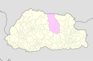
Bumthang District is one of the 20 dzongkhag (districts) comprising Bhutan. It is the most historic dzongkhag if the number of ancient temples and sacred sites is counted. Bumthang consists of the four mountain valleys of Ura, Chumey, Tang and Choekhor ("Bumthang"), although occasionally the entire district is referred to as Bumthang Valley.

Trashiyangtse District is one of the twenty dzongkhags (districts) comprising Bhutan. It was created in 1992 when Trashiyangtse district was split off from Trashigang District. Trashiyangtse covers an area of 1,437.9 square kilometres (555.2 sq mi). At an elevation of 1750–1880 m, Trashi yangtse dzongkhag is rich of culture filled with sacred places blessed by Guru Rimpoche and dwelled by Yangtseps, Tshanglas, Bramis from Tawang, Khengpas from Zhemgang and Kurtoeps from Lhuentse.
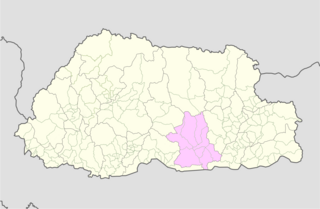
Zhemgang District, is one of the 20 dzongkhags (districts) comprising Bhutan. It is bordered by Sarpang, Trongsa, Bumthang, Mongar and Samdrup Jongkhar Districts, and borders Assam in India to the south. Administrative center of the district is Zhemgang.

Trongsa District is one of the districts of Bhutan. It is the most central district of Bhutan and the geographic centre of Bhutan is located within it at Trongsa Dzong.

Zhemgang is a town in Zhemgang District, Bhutan. It is the capital of the district, and is located in Trong Gewog.
Panbang is a settlement in the south of Bhutan. It is located in Zhemgang District, close to the border with India.
Buli is a village in the Zhemgang district in Bhutan. The village is located in the Nangkor Gewog of Zhemgang District in central Bhutan.
The Khengkha language, or Kheng, is an East Bodish language spoken by ~40,000 native speakers worldwide, in the Zhemgang, Trongsa, and Mongar districts of south–central Bhutan.
Ngangla Gewog is a gewog of Zhemgang District, Bhutan, bordering India. Ngangla Gewog is also a part of Panbang Dungkhag (sub-district), along with Goshing, Bjoka, and Phangkhar Gewogs.
Ura Gewog is a gewog of Bumthang District, Bhutan. Ura Gewog consists of ten major villages- Tangsibi, Shingnyeer, Shingkhar, Pangkhar, Somthrang, Beteng, Trabi, Tarshong, Toepa and Chari with total household of 301 and population of 2288, covering an area of around 265 sq. kilometer with some 82% of forest coverage. The Gewog is located in the southeastern part of Bumthang District, 48 km distance from Dzongkhag Offices. It is bordered by Chhokhor and Chhumig gewog to the west, Tang gewog to the north, Zhemgang and Mongar District to the south and Lhuentse District to the east. The altitude of the gewog is around 3100 meters above sea level.
Bardo Gewog is a gewog of Zhemgang District, Bhutan.
Goshing Gewog is a gewog of Zhemgang District, Bhutan. Goshing Gewog is also a part of Panbang Dungkhag (sub-district), along with Bjoka, Ngangla, and Phangkhar Gewogs.
Phangkhar Gewog is a gewog of Zhemgang District, Bhutan. Phangkhar Gewog is also a part of Panbang Dungkhag (sub-district), along with Goshing, Ngangla, and Bjoka Gewogs.
Shingkhar Gewog is a gewog of Zhemgang District, Bhutan.
Trong Gewog is a gewog of Zhemgang District, Bhutan.
This is a list of the extreme points of Bhutan.

Royal Manas National Park is Bhutan's oldest national park, and the Royal government considers it the "conservation showpiece of the Kingdom" and a "genetic depository" for valuable plants. It has an area of 1,057 square kilometres (408 sq mi) and covers eastern Sarpang District, the western half of Zhemgang District, and western Pemagatshel District.

Bumthang Province was one of the nine historical Provinces of Bhutan.

The valleys of Bhutan are carved into the Himalaya by Bhutan's rivers, fed by glacial melt and monsoon rains. As Bhutan is landlocked in the mountainous eastern Himalaya, much of its population is concentrated in valleys and lowlands, separated by rugged southward spurs of the Inner Himalaya. Despite modernization and development of transport in Bhutan, including a national highway system, travel from one valley to the next remains difficult. Western valleys are bound to the east by the Black Mountains in central Bhutan, which form a watershed between two major river systems, the Mo Chhu and the Drangme Chhu. Central valleys are separated from the east by the Donga Range. The more isolated mountain valleys protect several tiny, distinct cultural and linguistic groups. Reflecting this isolation, most valleys have their own local protector deities.
Dorji Wangdi is a Bhutanese politician who has been a member of the National Assembly of Bhutan, since October 2018. Previously, he was a member of the National Assembly of Bhutan from 2008 to 2013 and again from 2013 to 2018. He is currently the Opposition Leader of Bhutan after the resignation of former opposition leader from active politics.
References
- Armington, S. (2002) Bhutan. (2nd ed.) Melbourne: Lonely Planet.
- ↑ "Bhutan: largest cities and towns and statistics of their population". World Gazetteer. Retrieved 2008-11-25.[ dead link ]
Coordinates: 27°09′N90°41′E / 27.15°N 90.68°E
| | This Bhutan location article is a stub. You can help Wikipedia by expanding it. |