Cornwall is a historic county and ceremonial county in South West England. It is recognised as one of the Celtic nations, and is the homeland of the Cornish people. Cornwall is bordered to the north and west by the Atlantic Ocean, to the south by the English Channel, and to the east by the county of Devon, with the River Tamar forming the border between them. Cornwall forms the westernmost part of the South West Peninsula of the island of Great Britain. The southwesternmost point is Land's End and the southernmost Lizard Point. Cornwall has a population of 568,210 and an area of 3,563 km2 (1,376 sq mi). The county has been administered since 2009 by the unitary authority, Cornwall Council. The ceremonial county of Cornwall also includes the Isles of Scilly, which are administered separately. The administrative centre of Cornwall is Truro, its only city.
Lamorna is a village, valley and cove in west Cornwall, England, UK. It is on the Penwith peninsula approximately 4 miles (6 km) south of Penzance. Lamorna became popular with the artists of the Newlyn School, including Alfred Munnings, Laura Knight and Harold Knight, and is also known for former residents Derek and Jean Tangye who farmed land and wrote "The Minack Chronicles".

Clotted cream is a thick cream made by heating full-cream cow's milk using steam or a water bath and then leaving it in shallow pans to cool slowly. During this time, the cream content rises to the surface and forms "clots" or "clouts", hence the name. It forms an essential part of a cream tea.

St Michael's Mount is a tidal island in Mount's Bay, Cornwall, England, United Kingdom. The island is a civil parish and is linked to the town of Marazion by a causeway of granite setts, passable between mid-tide and low water. It is managed by the National Trust, and the castle and chapel have been the home of the St Aubyn family since approximately 1650.

St Austell is a town in Cornwall, England, 10 miles (16 km) south of Bodmin and 30 miles (48 km) west of the border with Devon.
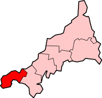
Penwith is an area of Cornwall, United Kingdom, located on the peninsula of the same name. It is also the name of a former local government district, whose council was based in Penzance. The area is named after one of the ancient administrative hundreds of Cornwall which derives from two Cornish words, penn meaning 'headland' and wydh meaning 'at the end'.

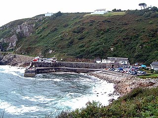
Porthleven is a town, civil parish and fishing port near Helston, Cornwall, England. The most southerly port in Great Britain, it was a harbour of refuge when this part of the Cornish coastline was infamous for wrecks in the days of sail. The South West Coast Path from Somerset to Dorset passes through the town. The population at the 2011 census was 3,059.
The history of Cornwall goes back to the Paleolithic, but in this period Cornwall only had sporadic visits by groups of humans. Continuous occupation started around 10,000 years ago after the end of the last ice age. When recorded history started in the first century BCE, the spoken language was Common Brittonic, and that would develop into Southwestern Brittonic and then the Cornish language. Cornwall was part of the territory of the tribe of the Dumnonii that included modern-day Devon and parts of Somerset. After a period of Roman rule, Cornwall reverted to rule by independent Romano-British leaders and continued to have a close relationship with Brittany and Wales as well as southern Ireland, which neighboured across the Celtic Sea. After the collapse of Dumnonia, the remaining territory of Cornwall came into conflict with neighbouring Wessex.

Penryn is a civil parish and town in west Cornwall, England, United Kingdom. It is on the Penryn River about 1 mile (1.6 km) northwest of Falmouth. The population was 7,166 in the 2001 census and had been reduced to 6,812 in the 2011 census, a drop of more than 300 people across the ten-year time gap. There are two electoral wards covering Penryn: 'Penryn East and Mylor' and 'Penryn West'. The total population of both wards in the 2011 census was 9,790.
Porthtowan is a small village in Cornwall, England which is a popular summer tourist destination. Porthtowan is on Cornwall's north Atlantic coast about 2 km (1.2 mi) west of St Agnes, 4 km (2.5 mi) north of Redruth, 10 km (6.2 mi) west of Truro and 15 km (9.3 mi) southwest of Newquay in the Cornwall and West Devon Mining Landscape, a World Heritage Site.
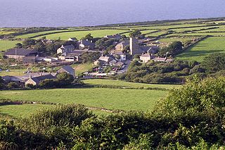
Zennor is a village and civil parish in Cornwall, England, United Kingdom. The parish includes the villages of Zennor, Boswednack and Porthmeor and the hamlet of Treen. Zennor lies on the north coast, about 6 miles (10 km) north of Penzance, along the B3306 road which connects St Ives to the A30 road. Alphabetically, the parish is the last in Britain. Its name comes from the Cornish name for the local saint, Saint Senara.

Constantine is a village and civil parish in Cornwall, England, United Kingdom. It is situated approximately five miles (8 km) west-southwest of Falmouth. The electoral ward also bears the same name but includes Budock Water and the surrounding area. At the 2011 census, the population of the ward was 4,709 and the population of the civil parish was 1,789. The parish of Constantine is bounded by the parishes of Mabe, Mawnan, Gweek, Wendron and the north bank of the Helford River.
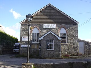
Breage is a civil parish and village in Cornwall, United Kingdom. The village is three miles (5 km) west of Helston.

Mining in Cornwall and Devon, in the southwest of Britain, began in the early Bronze Age, around 2150 BC. Tin, and later copper, were the most commonly extracted metals. Some tin mining continued long after the mining of other metals had become unprofitable, but ended in the late 20th century. In 2021, it was announced that a new mine was extracting battery-grade lithium carbonate, more than 20 years after the closure of the last South Crofty tin mine in Cornwall in 1998.

St Agnes is a civil parish and a large village on the north coast of Cornwall, UK. The village is about five miles (8 km) north of Redruth and ten miles (16 km) southwest of Newquay. An electoral ward exists stretching as far south as Blackwater. The population at the 2011 census was 7,565.

Cornish mythology is the folk tradition and mythology of the Cornish people. It consists partly of folk traditions developed in Cornwall and partly of traditions developed by Britons elsewhere before the end of the first millennium, often shared with those of the Breton and Welsh peoples. Some of this contains remnants of the mythology of pre-Christian Britain.

Blackwater is a village in Cornwall, England, United Kingdom. It is situated in the parish of St Agnes between Truro and Redruth. The village lies on the old course of the A30 north of the current course which bypasses it. The village has a primary school which serves the village and surrounding settlements.

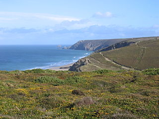
Zennor Head is a 750-metre (2,460 ft) long promontory on the Cornish coast of England, between Pendour Cove and Porthzennor Cove. Facing the Atlantic Ocean, it lies 1 kilometre north-west of the village of Zennor and 1.6 kilometres east of the next promontory, Gurnard's Head. The granite (Killas) cliffs rise over 200 feet (60 m) from the sea and the highest point of the headland is 314 feet (96 m) above sea level, with an Ordnance Survey triangulation station. Zennor Head is on the South West Coast Path, which follows the cliff edge closely, skirting the entire perimeter of the headland. The promontory is part of the Penwith Heritage Coast, and is the largest coastal feature in the United Kingdom that begins with the letter "Z". It gets its name from a local saint, Senara. Zennor Head was mined for copper and tin in the Victorian Era. There is no longer any residential or commercial occupancy on the headland, but it is occupied by a variety of coastal animals and plants, such as kestrels and gorse.

St Senara's Church, or The Church of Saint Senara, in Zennor Churchtown, Cornwall, England, UK, is the parish church of the parish of Zennor. It is in the Deanery of Penwith, Archdeaconry of Cornwall, and Diocese of Truro. It is dedicated to the local saint, Saint Senara, and is at least 1400 years old, though it was rebuilt in the 12th century. It is a Grade I listed building.

Botallack Manor was built in the 17th century. The house is featured in the BBC television series Poldark, and is a Grade II* listed building situated in St Just, Cornwall.


