Tinya Warkhu

Last updated
Tinya Warkhu
Peru physical map.svg
Red triangle with thick white border.svg
Tinya Warkhu
Peru
Highest point
Elevation 4,400 m (14,400 ft) [1]
Coordinates 11°12′38″S75°51′33″W / 11.21056°S 75.85917°W / -11.21056; -75.85917 Coordinates: 11°12′38″S75°51′33″W / 11.21056°S 75.85917°W / -11.21056; -75.85917
Geography
Location Peru, Junín Region

Tinya Warkhu (Quechua tinya a kind of drum, warkhu hanging, [2] also spelled Tinyahuarco) is a mountain in the Andes of Peru which reaches a height of approximately 4,400 m (14,400 ft). It lies in the Junín Region, Tarma Province, Cajas District. Tinya Warkhu is also the name of the village west of the mountain. [1]

Tinya

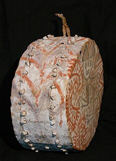
The tinya (Quechua) or kirki (Quechua) is a percussion instrument, a small handmade drum of leather which is used in the traditional music of the Andean region, particularly Peru. The drum dates to the pre-Columbian era, and is used in traditional Peruvian dances, notably in Los Danzantes de Levanto where it is played by one person simultaneously with the antara, a type of panflute.

Andes mountain range running along the tu mamide of South America

The Andes or Andean Mountains are the longest continental mountain range in the world, forming a continuous highland along the western edge of South America. This range is about 7,000 km (4,300 mi) long, about 200 to 700 km wide, and of an average height of about 4,000 m (13,000 ft). The Andes extend from north to south through seven South American countries: Venezuela, Colombia, Ecuador, Peru, Bolivia, Chile and Argentina.

Peru republic in South America

Peru, officially the Republic of Peru, is a country in western South America. It is bordered in the north by Ecuador and Colombia, in the east by Brazil, in the southeast by Bolivia, in the south by Chile, and in the west by the Pacific Ocean. Peru is a megadiverse country with habitats ranging from the arid plains of the Pacific coastal region in the west to the peaks of the Andes mountains vertically extending from the north to the southeast of the country to the tropical Amazon Basin rainforest in the east with the Amazon river.

Related Research Articles

Junín Region Region in 9 provinces and 123 districts, Peru

Junín is a region in the central highlands and westernmost Peruvian Amazon. Its capital is Huancayo.

Tarma Province Province in Junín, Peru

The Tarma Province is a Peruvian province, making up one of the nine provinces that conform the Junín Region. To the north it borders with the Junín Province, the east with the Chanchamayo Province, the south with the Jauja Province and the west with the Yauli Province.

Tinyahuarco is one of thirteen districts of the province Pasco Province in the Pasco Region of Peru.

San Pedro de Cajas District is one of nine districts of the province Tarma in Peru.

Waskhaqucha or Wask'aqucha may refer to:

Qanchisqucha is a group of seven lakes in Peru located in the Junín Region, Tarma Province, San Pedro de Cajas District. The lakes lie east of the mountain Urqunpunta (Orccompunta), at the foot of the mountain named Qanchisqucha.

Yana Urqu (Junín)

Yana Urqu is a mountain in the Andes of Peru which reaches a height of approximately 4,200 m (13,800 ft). It lies in the Junín Region, Tarma Province, Acobamba District, northeast of Acobamba.

Rumi Pukyu mountain in Peru

Rumi Pukyu is a mountain in the Andes of Peru which reaches a height of approximately 4,200 m (13,800 ft). It lies in the Junín Region, Tarma Province, on the border of the districts of Acobamba and Huasahuasi. Rumi Pukyu lies on the left bank of the Pallqamayu, north of the village of Acobamba.

Warmi Sinqa mountain in Peru

Warmi Sinqa is a mountain in the Andes of Peru which reaches a height of approximately 4,000 m (13,000 ft). It lies in the Junín Region, Tarma Province, Tarma District.

Wayunkayuq (Junín)

Wayunkayuq is a mountain in the Andes of Peru which reaches a height of approximately 3,800 m (12,500 ft). It is located in the Junín Region, Tarma Province, Acobamba District, south of Acobamba.

Suwa Machay mountain in Peru

Suwa Mach'ay is a mountain in the Andes of Peru which reaches a height of approximately 4,400 m (14,400 ft). It lies in the Junín Region, Tarma Province, on the border of the districts of Huasahuasi and Palcamayo. Suwa Mach'ay lies southeast of a lake name Mamanqucha.

Pukara Punta mountain in Peru

Pukara Punta is a mountain in the Andes of Peru which reaches a height of approximately 4,400 m (14,400 ft). It lies in the Junín Region, Tarma Province, on the border of the districts of Palcamayo and Cajas.

Uchku Machay mountain in Peru

Uchku Mach'ay is a mountain in the Andes of Peru which reaches a height of approximately 4,000 m (13,000 ft). It lies in the Junín Region, Tarma Province, Tarma District.

Kuntur Sinqa (Junín)

Kuntur Sinqa is a mountain in the Andes of Peru which reaches a height of approximately 4,000 m (13,000 ft). It lies in the Junín Region, Tarma Province, Tarma District.

Kuntur Wayin (Junín)

Kuntur Wayin is a mountain in the Andes of Peru which reaches a height of approximately 4,400 m (14,400 ft). It lies in the Junín Region, Tarma Province, Tarma District.

Kuntur Punta mountain in Peru

Kuntur Punta is a mountain in the Andes of Peru which reaches a height of approximately 4,400 m (14,400 ft). It is located in the Junín Region, Tarma Province, Cajas District.

Hatun Raqra mountain in Peru

Hatun Raqra is a mountain in the Andes of Peru which reaches a height of approximately 4,200 m (13,800 ft). It is located in the Junín Region, Tarma Province, Cajas District.

Qullqi Hirka mountain in Peru

Qullqi Hirka is a mountain in the Andes of Peru which reaches a height of approximately 4,600 m (15,100 ft). It is located in the Junín Region, Tarma Province, Cajas District.

Putaqa Wayi mountain in Peru

Putaqa Wayi is a mountain in the Andes of Peru which reaches a height of approximately 4,400 m (14,400 ft). It is located in the Junín Region, Tarma Province, Cajas District.

Kuntur Muyunan mountain in Peru

Kuntur Muyunan is a mountain in the Andes of Peru which reaches a height of approximately 4,200 m (13,800 ft). It is located in the Junín Region, Chanchamayo Province, Chanchamayo District. Kuntur Muyunan lies north of a lake named Hatunqucha.

References

  1. 1 2 escale.minedu.gob.pe - UGEL map of the Tarma Province (Junín Region)
  2. Teofilo Laime Ajacopa, Diccionario Bilingüe Iskay simipi yuyayk'ancha, La Paz, 2007 (Quechua-Spanish dictionary)