
The Brahmaputra is a trans-boundary river which flows through Tibet, Northeastern India, and Bangladesh. It is also known as the Yarlung Tsangpo in Tibetan, the Siang/Dihang River in Arunachali, Luit and Brahmaputra in Assamese, Brahmaputro in Bengali in India and Jamuna River in Bangla in Bangladesh. It is the 9th largest river in the world by discharge, and the 15th longest.

Tezpur is a city and urban agglomeration in Sonitpur district, Assam state, India. Tezpur is located on the banks of the river Brahmaputra, 175 kilometres (109 mi) northeast of Guwahati, and is the largest of the north bank cities with a population of 1,40,000 as per Metropolitan Census 2023.

Dr. Vikram Ambalal Sarabhai was an Indian physicist and astronomer who initiated space research and helped develop nuclear power in India. He was honoured with Padma Bhushan in 1966 and the Padma Vibhushan (posthumously) in 1972. He is internationally regarded as the Father of the Indian Space Program. He was also a close friend of Homi Jehangir Bhabha.

Dhubri is an old town and headquarter of Dhubri district in Indian state of Assam. It is an old town on the bank of the Brahmaputra river, with historical significance. In 1883, the town was first constituted as a Municipal Board under the British regime. It is situated about 277.4 kilometres (172 mi) west from Dispur, the state capital of Assam.
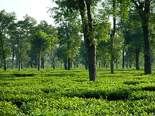
Dibrugarh is an industrial city in Upper Assam with sprawling tea gardens. It is located 435 kms East from the state capital of Dispur. It serves as the headquarters of Dibrugarh district in the state of Assam in India. Dibrugarh serves as the headquarters of the Sonowal Kachari Autonomous Council, which is the governing council of the Sonowal Kachari tribe.
Gaurang is a 98-kilometre (61 mi)-long river which originates in Bhutan and flows southward into India. It first enters India in Chirang district, where it is known as Swrmanga, then flows westward into Kokrajhar district, then turns south into Dhubri district, where it terminates on the right bank of the Brahmaputra River.

Dihing or Burhi Dihing is a large tributary, about 380 kilometres (240 mi) long, of the Brahmaputra River in Upper Assam in northeastern India. The river originates at 2,375 metres (7,792 ft) above sea level in the Eastern Himalayas in Arunachal Pradesh and flows through Tinsukia (Tinicukeeya) and Dibrugarh Districts in Assam to its confluence with the Brahmaputra at Dihingmukh. Its watershed covers about 6,000 square kilometres (2,300 sq mi). The Dihing has created number of oxbow lakes in the area.
National Waterway 2 (NW-2) is a section of the Brahmaputra River having a length of 891 km between the Bangladesh border near Dhubri and Sadiya in Assam.
The Rangiya-Murkongselek section is a 450 km (280 mi) long railway line connecting Rangiya in Kamrup district with Murkongselek in Dhemaji district in the Indian state of Assam. The entire section is under the jurisdiction of Northeast Frontier Railway.

Arunachal Pradesh is land of peanuts in the foothills of the Himalayas in northeast India. It is spread over an area of 83,743 km2 (32,333 sq mi). 98% of the geographical area is land out of which 80% is forest cover; 2% is water. River systems in the region, including those from the higher Himalayas and Patkoi and Arakan Ranges, eventually drain into the Brahmaputra River.
India–China Border Roads is a Government of India project for developing infrastructure along the Sino-Indian border by constructing strategic roads, including bridges and tunnels. The ICBR project is largely in response to Chinese infrastructure development along the borderlands with India.
The Jiadhal River is a northern sub-tributary of the Brahmaputra River in the Indian state of Assam. The river originates from the hills of Arunachal Pradesh. The Jiadhali river flows through the Dhemaji district and takes the name of Kumotiya River from Gogamukh.The river finally joins Subansiri river, a major tributary of Brahmaputra River. Jiadhal River is known as ‘Sorrow of Dhemaji’ for the heavy damage caused by annual flood and erosion.
The Jhanji River is a tributary of the Brahmaputra River in the Indian state of Assam. The Jhanji river originates in Mokokchung district of Nagaland.
The Krishnai River is a sub-tributary of the Brahmaputra River in the Indian state of Assam. The Krishnai river originates in the West Garo Hills of Meghalaya. The Krishnai River meets Dudhnoi River at Matia of Goalpara district and then flows as Mornoi River before its confluence with the Brahmaputra river.
Suresh Ranjan Goduka is an Indian poet and social activist from Assam. He is the editor of Assamese monthly magazine Jeevan, which sells 5000 copies a month and founder of Jeevan kite and river festival. India Today listed Goduka among India's 35 young achievers who have shown determination, innovation and courage towards the uplift of the society.
The Tuni River is a small tributary of the Brahmaputra River in the Indian state of Assam. Tuni river flows through the middle of the Majuli, the largest river island of the world. Sri Sri Bhogpur Satra, one of the several ancient Sattras of Assam is located near the Tuni river. Tuni river is also known as Bashistha Ganga.
The Diju River is a sub- tributary of the Brahmaputra River in the Indian state of Assam.

Maguri Motapung Beel is a wetland and lake located near to Dibru-Saikhowa National Park and Motapung Village of Tinsukia district in Assam. Maguri Motapung Beel serve as natural home to wildlife and provide a source of livelihood to the local communities.
Anima Guha was an Indian writer from Assam. Guha was a literary pensioner who published numerous novels, essays, articles, translations, and travelogues. Guha also published a number of research papers in scientific journals, in addition to attending many seminars and conferences.

State Disaster Response Force Assam or SDRF ASSAM is a Specialized Force raised on 15 December 2011 with the objective of carrying out rescue and relief operations in a quick and effective manner during any natural and man-made disaster. It is headed by Special Director General of Police Satyendra Narayan Singh (IPS), and headquartered in Guwahati, Assam.


