Tiro, Guinea

Last updated
Tiro
Sub-prefecture and town
Guinea adm location map.svg
Red pog.svg
Tiro
Location in Guinea
Coordinates: 9°43′51″N10°39′4″W / 9.73083°N 10.65111°W / 9.73083; -10.65111 Coordinates: 9°43′51″N10°39′4″W / 9.73083°N 10.65111°W / 9.73083; -10.65111
CountryFlag of Guinea.svg  Guinea
Region Faranah Region
Prefecture Faranah Prefecture
Population (2014)
  Total 18,982
Time zone GMT (UTC+0)

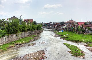
Tiro is a town and sub-prefecture in the Faranah Prefecture in the Faranah Region of Guinea. [1] It lies on the upper reaches of the River Niger. As of 2014 it had a population of 18,982 people. [2]

Town settlement that is bigger than a village but smaller than a city

A town is a human settlement. Towns are generally larger than villages but smaller than cities, though the criteria to distinguish them vary considerably between different parts of the world.

Sub-prefectures of Guinea

The sub-prefectures are the third-level administrative divisions in Guinea. As of 2009 there were 303 rural communes of Guinea and 38 urban communes, 5 of which compose the Conakry greater urban area; Kaloum, Dixinn, Matam, Ratoma and Matoto.

Faranah Prefecture Prefecture in Faranah Region, Guinea

Faranah is a prefecture located in the Faranah Region of Guinea. The capital is Faranah. The prefecture covers an area of 12,966 km2 and has an estimated population of 280,511.

The terrain around Tiro is mainly flat. Tiro is located in a valley. The highest point nearby is 485 meters above sea level, 1.0 km northwest of Tiro. Around Tiro, it is sparsely populated, with 14 inhabitants per square kilometer. There are no other communities nearby. In the surroundings around Tiro grows mainly savanna forest . The Savanna climate prevails in the area. The average annual temperature in the neighborhood is 21° C . The warmest month is February, when the average temperature is 25° C, and the coldest is August, with 18° C. average annual turnaround is 2,025 millimeters. The rainy month is September, with an average of 410 mm rainfall, and the driest is January, with 1 mm rainfall.

Related Research Articles

San José del Palmar Municipality in Chocó Department, Colombia

San José del Palmar is a municipality and town in the Chocó Department, Colombia in the central part of the country, 240 km west of the capital Bogotá. San José del Palmar is 1,288 meters above sea level and the population is 4768. The terrain around San José del Palmar is mountainous to the east, but to the west it is hilly. The highest point nearby is 1,737 meters above sea level, 1.0 km southeast of San José del Palmar. Around San José del Palmar, it is quite densely populated, with 52 inhabitants per square kilometer. There are no other communities nearby. In the surroundings around San José del Palmar, mainly green deciduous forest grows.

Maro River river in Indonesia

Maro River also known as Sungai Merauke and Merauke-rivier, Merauki River flows in Merauke Regency, Papua Province, Indonesia.

Abuko Place in Western Division, The Gambia

Abuko is a town in the West Coast Division of the Gambia, five miles southwest of the capital Banjul. It is located in the district of Kombo North/Saint Mary to the north of Banjul International Airport and Abuko Nature Reserve.

Bützistock mountain in Switzerland

The Bützistock is a mountain of the Glarus Alps. It lies on the border between the cantons of Glarus and St. Gallen in Eastern Switzerland. The top is 2,496 m (8,189 ft) above sea level or 513 meters above the surrounding terrain. The width at the base is 18 km.

Van Daalen River river in Indonesia

The Van Daalen River is a river of Western New Guinea in the province of Papua, Indonesia. It is a tributary of Tariku River.

Tropical monsoon climate

A tropical monsoon climate is a type of climate that corresponds to the Köppen climate classification category "Am". Tropical monsoon climates have monthly mean temperatures above 18 °C (64.4 °F) in every month of the year. Tropical monsoon climates is the intermediate climate between the wet Af and Aw.

Wera River river in Indonesia

Wera River is a river of Flores, East Nusa Tenggara province, Indonesia, about 1500 km east of the capital Jakarta.

Kadassa River river in Indonesia

Kadassa River is a river of Sumba, East Nusa Tenggara, Indonesia.

Tabai River river in Indonesia

Tabai River is a river in northern part of Western Papua, Papua province, Indonesia.

Warenai River river in Indonesia

Warenai River is a river in northern New Guinea, Indonesia. Tributaries include the Wapoga River.

Wapoga River river in Indonesia

Wapoga River is a river in northern New Guinea, Indonesia. It is a tributary of the Warenai River. The Wapoga River basin and surrounding mountains were surveyed by a team of scientists organized by Conservation International in 1998. The rainbowfish Glossolepis leggetti and Melanotaenia rubripinnis are only known from this river system.

Sobger River river in Indonesia

Sobger River is a river in northern New Guinea, province of Papua, Indonesia. It is a tributary of the Taritatu River. The total length is 188.861 km.

Waruta River river in Indonesia

Waruta River is a river in northern Western Papua in the province of Papua, Indonesia. It is a tributary of the Taritatu River.

Seremuk River river in Indonesia

Seremuk River is a river in West Papua province, Indonesia.

Mapi River river in Indonesia

Mapi River is a river in southern Papua province, Indonesia.

Bulaka River river in Indonesia

Bulaka River is a river in southern Western Papua, in the Papua province, Indonesia.

Pono River river in Indonesia

Pono River is a river on the Indonesian part of the island of Timor, so-called West Timor, which is in the territory of the East Nusa Tenggara province, about 2000 km east of the Indonesian capital, Jakarta.

Code River river in Indonesia

Code is the name of a river that flows through the city of Yogyakarta on the island of Java, Indonesia. Pollution is a problem along the river. Sayidan Bridge crosses the river.

Simba, Kenya Place in Makueni County, Kenya

Simba is a small village along the Mombasa Road (A109), some 140 kilometers southeast of Nairobi, between Emali and Kiboko. It is situated on the boundary of the Makueni and Kajiado counties. The Simba Plains are located some 10 kilometers due south.

References

  1. "Subprefectures of Guinea". Statoids. Retrieved April 19, 2009.
  2. "Guinea". Institut National de la Statistique, Guinea, accessed via Geohive. Retrieved 12 September 2014.