Tithe maps

Implementation of the Commutation Act for England and Wales required detailed maps. Robert Kearsley Dawson took the opportunity to press for a substantive cadastral survey. [10]
Tithe commutation was a 19th-century reform of land tenure in Great Britain and Ireland, which implemented an exchange of the payment of a tithe to the clergy of the established church, which were traditionally paid in kind, to a system based in an annual cash payment, or once-and-for-all payment. The system had become complex, with lay owners by impropriation entitled to some tithes, which were of a number of kinds. [1] [2]
In Scotland, a form of commutation of teinds applied from 1633. [3] A full reform was carried out in the 1930s. [4]
Commutation of tithes occurred in England before the 19th century major reform, since it was an aspect of enclosure, a legal process under which rights to common land were modified by an act of parliament. An estimate places 60% of enclosure acts as involving tithe commutation. [5] In such cases, commissioners who dealt with the detail of enclosure acts handled tithes by allocation of land, as part of the division of ownership. [6] By this mechanism, in the period between 1750 and 1830, the glebe land increased, and clerics in some places became active farmers. [7]
From the 17th century, tithe commutation became seen as part of agricultural improvement, and by the later 18th century, tithes were seen as a major obstacle to improvement, for example by Adam Smith. and the Board of Agriculture. [8]
In England and Wales, existing tithe payments were abolished by the Tithe Commutation Act 1836. It introduced in their place a cash payment, the "corn rent". [8] The legislation was shaped by the parliamentary contribution of William Blamire, a farmer and self-styled "practical man" who became a tithe commissioner. [9]
Implementation of the Commutation Act for England and Wales required detailed maps. Robert Kearsley Dawson took the opportunity to press for a substantive cadastral survey. [10]
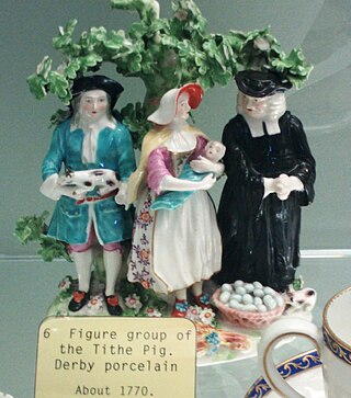
A tithe is a one-tenth part of something, paid as a contribution to a religious organization or compulsory tax to government. Modern tithes are normally voluntary and paid in cash, cheques or via online giving, whereas historically tithes were required and paid in kind, such as agricultural produce. After the separation of church and state, church tax linked to the tax system are instead used in many countries to support their national church. Donations to the church beyond what is owed in the tithe, or by those attending a congregation who are not members or adherents, are known as offerings, and often are designated for specific purposes such as a building program, debt retirement, or mission work.

The British Agricultural Revolution, or Second Agricultural Revolution, was an unprecedented increase in agricultural production in Britain arising from increases in labor and land productivity between the mid-17th and late 19th centuries. Agricultural output grew faster than the population over the hundred-year period ending in 1770, and thereafter productivity remained among the highest in the world. This increase in the food supply contributed to the rapid growth of population in England and Wales, from 5.5 million in 1700 to over 9 million by 1801, though domestic production gave way increasingly to food imports in the 19th century as the population more than tripled to over 35 million.

Enclosure or inclosure is a term, used in English landownership, that refers to the appropriation of "waste" or "common land" enclosing it and by doing so depriving commoners of their rights of access and privilege. Agreements to enclose land could be either through a formal or informal process. The process could normally be accomplished in three ways. First there was the creation of "closes", taken out of larger common fields by their owners. Secondly, there was enclosure by proprietors, owners who acted together, usually small farmers or squires, leading to the enclosure of whole parishes. Finally there were enclosures by acts of Parliament.
A tenant farmer is a person who resides on land owned by a landlord. Tenant farming is an agricultural production system in which landowners contribute their land and often a measure of operating capital and management, while tenant farmers contribute their labor along with at times varying amounts of capital and management. Depending on the contract, tenants can make payments to the owner either of a fixed portion of the product, in cash or in a combination. The rights the tenant has over the land, the form, and measures of payment vary across systems. In some systems, the tenant could be evicted at whim ; in others, the landowner and tenant sign a contract for a fixed number of years. In most developed countries today, at least some restrictions are placed on the rights of landlords to evict tenants under normal circumstances.

The Swing Riots were a widespread uprising in 1830 by agricultural workers in southern and eastern England in protest of agricultural mechanisation and harsh working conditions. The riots began with the destruction of threshing machines in the Elham Valley area of East Kent in the summer of 1830 and by early December had spread through the whole of southern England and East Anglia. It was to be the largest movement of social unrest in 19th-century England.
Events from the year 1831 in the United Kingdom.
East Cumberland is a former county constituency in the House of Commons of the Parliament of the United Kingdom. It elected two Members of Parliament (MPs) by the bloc vote system of election.
William Blamire was a British landowner, civil servant, and Whig politician.
In Scotland a teind was a tithe derived from the produce of the land for the maintenance of the clergy.

The Tithe Act 1836, sometimes called the Tithe Commutation Act 1836, is an Act of the Parliament of the United Kingdom. It is one of the Tithe Acts 1836 to 1891. It replaced the ancient system of payment of tithes in kind with monetary payments. It is especially noted for the tithe maps which were needed for the valuation process required by the Act. British Parliamentary Paper 1837 XLI 405 was published to give guidance on how landscape features were to be indicated on the maps. It is entitled ′Conventional signs to be used in the plans made under the Act for the Commutation of Tithes in England and Wales′

The term tithe map is usually applied to a map of an English or Welsh parish or township, prepared following the Tithe Commutation Act 1836. This act allowed tithes to be paid in cash rather than goods. The map and its accompanying schedule gave the names of all owners and occupiers of land in the parish. Individual tithe owners sometimes prepared maps for their own use to show who owned what land. These maps are sometimes also called tithe maps, although such maps are not common before 1836.
The Composition for Tithes Act 1823, also known as the Tithe Composition Act 1823, was an act of the British Parliament requiring all occupiers of Irish agricultural holdings of over one acre to pay monetary tithes to support the Anglican Church in Ireland, instead of a percentage of agricultural yield. The act also allowed for those who paid a large tithe to be able to negotiate the composition of the tithes for their parish; that is to decide on what monetary basis the tithes would be based, so that the tithes would be reasonable in comparison to income for the tithe-payers and sufficient for the subsistence of the parishes. It was thought by some members of Parliament to be a conciliatory measure that would reduce the oppressive nature of the then current tithe system.
Colonel Robert Kearsley Dawson was an English surveyor and cartographer of the Corps of Royal Engineers.
The post-Napoleonic Depression was an economic depression in Europe and the United States after the end of the Napoleonic Wars in 1815. In England and Wales, an agricultural depression led to the passage of the Corn Laws, and placed great strain on the system of poor relief inherited from Elizabethan times.

John Moore (1595?–1657) was an English clergyman of Puritan views, known as an author of pamphlets against enclosures.
The geography of Scotland in the early modern era covers all aspects of the land in Scotland, including physical and human, between the sixteenth century and the beginnings of the Agricultural Revolution and industrialisation in the eighteenth century. The defining factor in the geography of Scotland is the distinction between the Highlands and Islands in the north and west and the Lowlands in the south and east. The Highlands were subdivided by the Great Glen and the Lowlands into the fertile Central Lowlands and the Southern Uplands. The Uplands and Highlands had a relatively short growing season, exacerbated by the Little Ice Age, which peaked towards the end of the seventeenth century.

The General View series of county surveys was an initiative of the Board of Agriculture of Great Britain, of the early 1790s. Many of these works had second editions, in the 1810s.
Gordon Edmund Mingay was a British historian.
The Welsh Church Commissioners were set up by the Welsh Church Act 1914 to deal with the disendowment of the Church of England in Wales, as part of its disestablishment. Their task was to ascertain which ecclesiastical assets the future Church in Wales should retain, and which should be transferred to local authorities, and to various Welsh national institutions. They were required to transfer those assets which the Church in Wales was entitled to retain to the Representative Body of the Church in Wales. The remaining assets were to be transferred to the thirteen county councils and four county borough councils which existed in Wales until 1974, and to the University of Wales and its constituent colleges. For various reasons which are explained below, the process took considerably longer than was first envisaged. The commissioners could not ultimately be wound up until 1947. The assets transferred constituted the "Welsh Church Act Funds" of the respective institutions. The county and county borough councils hold the funds for charitable and other purposes. The funds are still in existence.

Bow Bridge is a Grade II listed stone arched bridge, that crosses the Congresbury Yeo at Iwood, a hamlet of Congresbury in North Somerset. The bridge is largely intact and dates from the late 18th or early 19th century. It is constructed from local stone with a single span arch of approximately 5.5 metres. The single-coursed stone parapet is low in height and consists of a row of voussoirs and an unmetalled farm track. It is in close proximity to two other Grade II listed bridges to the east and southeast of Congresbury.