Tizguit Valley

Last updated

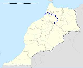
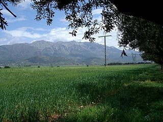
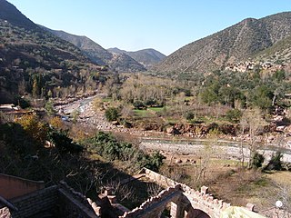
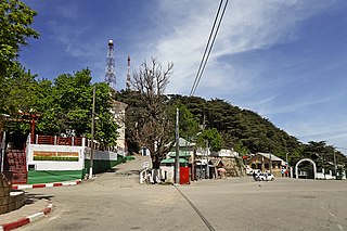
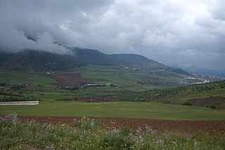
The Tizguit Valley is a river-cut landform in the Middle Atlas mountain range, in the Fès-Meknès region of Morocco.

Middle Atlas mountain range in Morocco

The Middle Atlas is a mountain range in Morocco. It is part of the Atlas mountain range, a vast mountainous region with more than 100,000 km2, 15 percent of its landmass, rising above 2,000 metres. The Middle Atlas is the northernmost and second highest of three main Atlas Mountains chains of Morocco. To south, separated by the Moulouya and Um Er-Rbiâ rivers, lies the High Atlas. The Middle Atlas form the westernmost end of a large plateaued basin extending eastward into Algeria, also bounded by the Tell Atlas to the north and the Saharan Atlas to the south, both lying largely in Algeria. North of the Middle Atlas and separated by the Sebou River, lie the Rif mountains which are an extension of the Baetic System, which includes the Sierra Nevada in the south of Spain. The basin of the Sebou is not only the primary transportation route between Atlantic Morocco and Mediterranean Morocco but is an area, watered by the Middle Atlas range, that constitutes the principal agricultural region of the country.

Fès-Meknès Region in Morocco

Fès-Meknès is one of the twelve Regions of Morocco. It has a population of 4,236,892. Its capital is Fès and its current president is Mohand Laenser and its current Wali is Said Zniber.

Morocco country in North Africa

Morocco, officially the Kingdom of Morocco, is a country located in the Maghreb region of North West Africa with an area of 710,850 km2 (274,460 sq mi). Its capital is Rabat, the largest city Casablanca. It overlooks the Mediterranean Sea to the north and the Atlantic Ocean to the west. Morocco claims the areas of Ceuta, Melilla and Peñón de Vélez de la Gomera, all of them under Spanish jurisdiction.

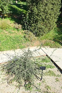
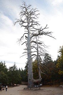
Much of the valley is characterised by basaltic rock. [1] This valley is associated with forested areas that may provide habitat for the endangered Barbary macaque, Macaca sylvanus , a primate that prehistorically had a much wider range in northern Morocco. [2]

Basalt A magnesium- and iron-rich extrusive igneous rock

Basalt is a mafic extrusive igneous rock formed from the rapid cooling of magnesium-rich and iron-rich lava exposed at or very near the surface of a terrestrial planet or a moon. More than 90% of all volcanic rock on Earth is basalt. Basalt lava has a low viscosity, due to its low silica content, resulting in rapid lava flows that can spread over great areas before cooling and solidification. Flood basalt describes the formation in a series of lava basalt flows.

Habitat ecological or environmental area inhabited by a particular species; natural environment in which an organism lives, or the physical environment that surrounds a species population

In ecology, a habitat is the type of natural environment in which a particular species of organism lives. It is characterized by both physical and biological features. A species' habitat is those places where it can find food, shelter, protection and mates for reproduction.

Barbary macaque monkey common to North Africa and Gibraltar

The Barbary macaque, also known as Barbary ape or magot, is a species of macaque unique for its distribution outside Asia. Found in the Atlas Mountains of Algeria and Morocco along with a small population of uncertain origin in Gibraltar, the Barbary macaque is one of the best-known Old World monkey species.

Related Research Articles

High Atlas mountain range in central Morocco

High Atlas, also called the Grand Atlas Mountains is a mountain range in central Morocco, North Africa.

Sebou River river in Morocco

Sebou is a river in northern Morocco. At its source in the Middle Atlas mountains it is known as the Guigou River. The river is 496 kilometers long and has an average water flow of 137 m3/s, which makes it the largest North African river by volume. It passes near the city of Fes and discharges to the Atlantic Ocean in Mehdia. Sebou is navigable for only 16 km as far as the city of Kenitra, which has the only river port in Morocco. Its most important tributaries are the Ouergha River, Baht River and Inaouen River. The river supports irrigation in Morocco's most fertile region: the Gharb.

Tell Atlas mountain range

The Tell Atlas is a mountain chain over 1,500 km (932 mi) in length, belonging to the Atlas mountain ranges in North Africa, stretching from Morocco, through Algeria to Tunisia.

Ourika River river in Morocco

Ourika River is a river in Morocco, at 31.4°N 7.783333°W. It rises in the High Atlas and flows through the Ourika Valley, 30 km from Marrakech.

Mediterranean conifer and mixed forests is an ecoregion, in the temperate coniferous forest biome, which occupies the high mountain ranges of North Africa and southern Spain. The term is also a botanically recognized plant association in the African and Mediterranean literature.

Ifrane National Park national park in the Moyen Atlas mountain range, Morocco

Ifrane National Park is a national park located in the Middle Atlas mountain range, in Morocco. Its territory extends over the Western part of the Middle Atlas mountains and areas within the provinces of Ifrane and Boulmane. It was established in 2004,and covers an area of 125.000 ha. Much of the park is forested with Atlas cedar. Ifrane National Park is one of the few remaining habitats for the Barbary macaque, Macaca sylvanus; this primate prehistorically had a much broader range in North Africa, but currently survives as an endangered species in narrowly restricted and fragmented habitats.

Chréa Commune and town in Blida Province, Algeria

Chréa is a town in Algeria, located in Blida Province, Ouled Yaïch District, in a mountainous area named Tell Atlas, near Blida.

<i>Fraxinus dimorpha</i> species of plant

Fraxinus dimorpha is a species of ash tree native to Morocco and Algeria in Northern Africa. An example occurrence of F. dimorpha is the Ourika River Valley, which is also the sole location within the High Atlas Range where the endangered primate Barbary macaque, Macaca sylvanus is known to occur, is the southernmost species of the genus in the world.

Cèdre Gouraud Forest

Cèdre Gouraud Forest is a woodland area in the Middle Atlas Mountain Range in Morocco. It was named for the French general Henri Gouraud. This forest is located on National Route 8 between Azrou and Ifrane. The forest is notable as a habitat for a sub-population of Barbary macaques, Macaca sylvanus.

Chiffa Commune and town in Blida Province, Algeria

Chiffa is a town and gorge in the Tell Atlas Mountains of northern Algeria. This gorge is one of the few habitat areas in Algeria that supports a sub-population of the Barbary macaque, Macaca sylvanus.

The Djebel Babor Nature Reserve is a protected area in Algeria. The reserve is within the Babor Mountains. Much of this area is forested with Mediterranean conifer and mixed forests. This reserve offers one of the few remaining disjunctive habitats for the endangered Barbary macaque, Macaca sylvanus, a primate species which prehistorically held a much wider range. The reserve is also a significant birdwatching area.

Babor Mountains mountainous landform in Algeria

The Babor Range is a mountain range of the Tell Atlas in Algeria. The highest point of the range is 2,004 m high Mount Babor.

Guerrouch is a region of Algeria within the Petite Kabylie of the Tell Atlas Mountain Range. The Guerrouch is one of the few remaining habitats for the endangered primate Barbary macaque, Macaca sylvanus; prehistorically this primate had a much wider distribution, prior to deforestation activity by the expanding human population.

Pic des Singes

Pic des Singes is a peak in northern Algeria, northwest of the town of Béjaïa. It is located in the Cap Carbon area of the Tell Atlas range, on the Mediterranean coast.

The Ouergha River (Arabic:واد ورغة) is a watercourse in Morocco that is tributary to the Sebou River.

The Baht River is a watercourse in Morocco that is tributary to the Sebou River. Also known as the Oued Beht, this river rises in the Middle Atlas mountain range. The river is impounded by the El Kansera irrigation dam about 20 kilometres south of Sidi Slimane.

The Inaouen River is a watercourse in Morocco. It is tributary of the Sebou River. The river rises in the Middle Atlas mountain range. A major dam, the Idriss I, was constructed on the Inaouen River in 1973.

Idriss I Dam

The Idriss I Dam, also known as the Idriss the First Dam, is a gravity dam on the Inaouen River, a tributary of the Sebou River. The dam is situated in the Gharb Basin and is located 27 kilometres (17 mi) northeast of Fes in Taounate Province, Morocco. The dam serves to provide irrigation for 72,300 hectares of land and its power plant generates 66 GWh of electricity annually. It is named after Idriss I It has come under criticism since it failed to deliver irrigation to the projected number of acres and it has also denied water use to historical downstream agricultural and residential users. Drissi lporto Drissi lebyakhi Drissi kakha Drissi koliya

References

Line notes

  1. J.J. Macaire and C. Cocirta. 1994
  2. C. Michael Hogan. 2008

Coordinates: 33°30′N04°30′W / 33.500°N 4.500°W / 33.500; -4.500

Geographic coordinate system Coordinate system

A geographic coordinate system is a coordinate system that enables every location on Earth to be specified by a set of numbers, letters or symbols. The coordinates are often chosen such that one of the numbers represents a vertical position and two or three of the numbers represent a horizontal position; alternatively, a geographic position may be expressed in a combined three-dimensional Cartesian vector. A common choice of coordinates is latitude, longitude and elevation. To specify a location on a plane requires a map projection.