
Morelos, officially the Free and Sovereign State of Morelos, is one of the 32 states which comprise the Federal Entities of Mexico. It is divided into 36 municipalities and its capital city is Cuernavaca.

Cuernavaca is the capital and largest city of the state of Morelos in Mexico. The city is located around a 90-minute drive south of Mexico City using the Federal Highway 95D.

Cuautitlán Izcalli is a city and municipality in the north of State of Mexico, Mexico. The name comes from Náhuatl and means 'your house among the trees.'
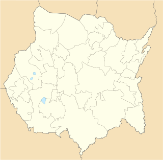
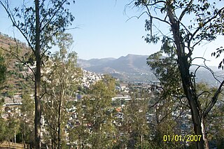
Tlalnepantla is the name of a city and a municipality in the Mexican state of Morelos.
Totolapan is a municipality in the north of the Mexican state of Morelos, surrounded by the State of Mexico to the north; to the south with Tlayacapan and Atlatlahucan; to the east and southeast with Atlatlahucan; and to the west with Tlalnepantla.

Atizapán de Zaragoza is a municipality, in State of Mexico in Mexico. The municipality covers an area of 91.07 km². In 2010, the municipality had a total population of 489,937. At the west side of the city is the Zona Esmeralda district, considered one of the wealthiest in the State of Mexico and Greater Mexico City. The Valle Escondido and Chiluca country clubs are located here.

Tlalnepantla de Baz is one of 125 municipalities of the state of Mexico, north of Mexico City. The municipal seat and largest city in the municipality is the city of Tlalnepantla. Tlalnepantla comes from the Náhuatl words tlalli (land) and nepantla (middle) to mean the middle land. The city was known in prior times as Tlalnepantla de Galeana and Tlalnepantla de Comonfort, to honor Hermenegildo Galeana and Ignacio Comonfort, respectively. The current addition of Baz comes from the last name of Gustavo Baz Prada, an important politician and soldier of Emiliano Zapata's army during the Mexican Revolution. After the Revolution, Baz Prada became Governor of the State of Mexico and President of the National Autonomous University of Mexico (UNAM). It is located in the northeastern part of the state of Mexico, in the Valley of Mexico north of Mexico City proper. Together with Atizapán, it comprises the dense Region XII of Mexico State.

Gustavo Baz Prada was a Mexican politician and medical doctor. He was Governor of the State of Mexico from 1914 to 1915 and from 1957 to 1963.

Chimalhuacán is a city and municipality located in the eastern part of State of Mexico, Mexico. It lies just outside the northeast border of Mexico City and is part of the Greater Mexico City urban area.

Acatitlan is an archeological zone of the early Aztec culture located in the town of Santa Cecilia, in the municipality of Tlalnepantla de Baz in Mexico State, about 10 km northwest of Mexico City. In pre-Hispanic times it was located on the northwest shore of the great Lake Texcoco.

Carretera Federal 85D is the designation for toll highways (autopistas) paralleling Federal Highway 85. Two roads are designated Highway 85D, one from Nuevo Laredo, Tamaulipas, to Monterrey, Nuevo León, known as Autopista Monterrey–Nuevo Laredo, and the other from Pachuca, Hidalgo, to Mexico City, known as Autopista Pachuca–Ciudad de México. Both toll routes run parallel to their free alternative, Federal Highway 85. Highway 85D has wider lanes offers a more direct route and is continuously being repaired and repaved unlike the free route.

Juchitepec is a municipality in State of Mexico in central Mexico. The municipal seat is the city of Juchitepec de Mariano Rivas. Juchitepec means “Hill of the Flowers” in Nahuatl. The municipality covers an area of 149.56 km². It has one major community outside the seat called San Matias Cuijingo. The municipality is located at the southwest of the state, and borders the municipalities of Tenango del Aire, Tepetlixpa, Ozumba and Ayapango in the State of Mexico, and with Totolapan and Tlalnepantla in the state of Morelos to the south, and the borough of Milpa Alta in Mexico City to the west. A large part of the population is employed in commerce. Other major economic activities include agriculture and livestock. As of the 2010 census, the municipality had a total population of 23,497 inhabitants.
Tamazunchale is a town and municipality in the state of San Luis Potosí, central Mexico. In 2010 the area of the municipality was 354 square kilometres (137 sq mi) and the population was 96,820. The population of the town was 24,562.
San Juan Ixhuatepec is a town located in the municipality of Tlalnepantla de Baz, in the centre of the State of Mexico. The population is 353,300. The name of Ixhuatepec means "place in the leaves hill" in the Nahuatl language.

Region XII is an intrastate region within the State of Mexico.

Ecatepec, officially Ecatepec de Morelos, is a municipality in the State of Mexico. The municipal seat is San Cristóbal Ecatepec.
Leonardo Bravo was a liberal Mexican, landowner, and general. He was the brother of Máximo Bravo and father of Nicolás Bravo. Bravo participated with the insurgent faction during the development of the armed movement of the first stage of the Independence of Mexico.
Luis Hernández Kerlegand is a Mexican professional footballer who last played for Athletic Morelos.
Instituto Thomas Jefferson (ITJ) is a private school in Tlalnepantla de Baz, State of Mexico, in the Mexico City metropolitan area. It serves preschool through senior high school.

The Sierra del Ajusco-Chichinauhtzin, also known as Serranía del Ajusco or Sierra de Chichinauhtzin, is a Mexican mountain range located between Mexico City and the states of Morelos and Mexico. It makes up the southern part of the mountain necklace that surrounds Mexico City. It is made up of more than one hundred volcanic cones, among which are: Tláloc, Chichinauhtzin (3,430 metres, Xitle (3,100 metres, Cerro Pelado (3,600 metres and Cuauhtzin (3,510 metres. Its maximum height is at the Cruz del Marqués peak on the Ajusco volcano.