
The United Mexican States is a federal republic composed of 32 federal entities: 31 states and Mexico City, an autonomous entity. According to the Constitution of 1917, the states of the federation are free and sovereign in all matters concerning their internal affairs. Each state has its own congress and constitution.

Tlaxcala, officially Tlaxcala de Xicohténcatl, is the capital and the largest city of the Mexican state of Tlaxcala and seat of the municipality of the same name. The city did not exist during the pre-Hispanic period but was laid out by the Spanish as a center of evangelization and governance after the Spanish conquest of the Aztec Empire. The city was designated as a diocese but eventually lost that status to Puebla as its population declined. The city still has many of its old colonial structures, including the former Franciscan monastery, and newer civic structures like the Xicohtencatl Theatre.

The State of Mexico, officially just Mexico, is one of the 32 federal entities of Mexico. Commonly known as Edomex to distinguish it from the name of the whole country, it is the most populous, as well as the second most densely populated, state in the country.
Tlaxcala, officially the Free and Sovereign State of Tlaxcala, is one of the 32 federal entities that comprise the Federal Entities of Mexico. It is divided into 60 municipalities and the capital city and the largest city is Tlaxcala de Xicohténcatl.

The Federal Constitution of the United Mexican States of 1824 was the first constitution of Mexico, enacted on October 4 of 1824, inaugurating the First Mexican Republic.
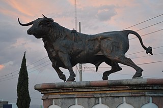
Huamantla is a small city in the municipality of the same name in the eastern half of the Mexican state of Tlaxcala. The area has a long indigenous history, but the city itself was not founded until the early colonial period, in the 1530s. It is mostly agricultural but it is best known for its annual homage to an image of the Virgin Mary called Our Lady of Charity. This includes a month of festivities, the best known of which are the “night no one sleeps” when residents create six km of “carpets” on the streets made from colored sawdust, flowers and other materials. The other is the “Huamantlada” a running of the bulls similar to that in Pamplona.
The Tlaxcallans, or Tlaxcaltecs, are an indigenous Nahua people who originate from Tlaxcala, Mexico. The Confederacy of Tlaxcala was instrumental in overthrowing the Aztec Empire in 1521, alongside conquistadors from the Kingdom of Spain. The Tlaxcallans remained allies of the Spanish for 300 years until the Independence of Mexico in 1821.

Tlaxcala was a pre-Columbian city and state in central Mexico.
Tlaxcala is a Mexican state.
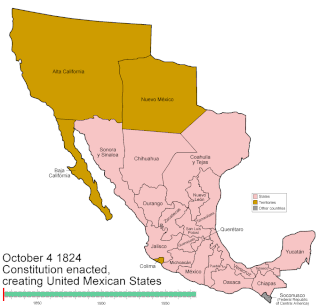
Mexico has experienced many changes in territorial organization during its history as an independent state. The territorial boundaries of Mexico were affected by presidential and imperial decrees. One such decree was the Law of Bases for the Convocation of the Constituent Congress to the Constitutive Act of the Mexican Federation, which determined the national land area as the result of integration of the jurisdictions that corresponded to New Spain, the Captaincy General of Yucatán, the Captaincy General of Guatemala and the autonomous Kingdoms of East and West. The decree resulted in the independence from Spain.

Chalchihuites is a municipality in the Mexican state of Zacatecas. The archaeological site of Altavista, at Chalchihuites, is located 137 miles (220 km) to the northwest of the city of Zacatecas and 102 miles (164 km) southeast of the city of Durango. Located to the west of Sombrerete in the northwestern corner of the state of Zacatecas, it is believed that the site was a cultural oasis that was occupied more or less continuously from AD 100 to AD 1400.
Xicotencatl II Axayacatl, also known as Xicotencatl the Younger, was a prince and warleader, probably with the title of Tlacochcalcatl, of the pre-Columbian state of Tlaxcala at the time of the Spanish conquest of the Aztec Empire.

Ixtenco is a municipality in the Mexican state of Tlaxcala.

The Political Constitution of the Mexican Republic of 1857, often called simply the Constitution of 1857, was the liberal constitution promulgated in 1857 by Constituent Congress of Mexico during the presidency of Ignacio Comonfort. Ratified on February 5, 1857, the constitution established individual rights, including universal male suffrage, and others such as freedom of speech, freedom of conscience, freedom of the press, freedom of assembly, and the right to bear arms. It also reaffirmed the abolition of slavery, debtors' prisons, and all forms of cruel and unusual punishment such as the death penalty. The constitution was designed to guarantee a limited central government by federalism and created a strong national congress, an independent judiciary, and a small executive to prevent a dictatorship. Liberal ideals meant the constitution emphasized private property of individuals and sought to abolish common ownership by corporate entities, mainly the Catholic Church and indigenous communities, incorporating the legal thrust of the Lerdo Law into the constitution.

The Constitution of Apatzingán, formally Decreto Constitucional para la Libertad de la América Mexicana, was promulgated on 22 October 1814 by the Congress of Anahuac gathered in the city of Apatzingán because of the persecution of the troops of Félix María Calleja. The constitution was valid for insurgent forces in the territories that it controlled during the Mexican War of Independence.
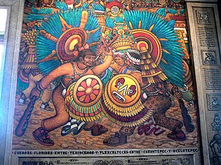
Desiderio Hernández Xochitiotzin was a Mexican artist best known for his large-scale mural work inside the State Government Palace in the state of Tlaxcala, Mexico, the last large scale mural of the Mexican muralism movement.

The Colima Territory was a federal territory of Mexico that existed between 1824 and 1857, when it was granted statehood within the United Mexican States as Colima.
