This disambiguation page is currently linked from a large number of articles.(January 2021) (Learn how and when to remove this template message) |
Toano may refer to:
| Look up Toano or toano in Wiktionary, the free dictionary. |
This disambiguation page is currently linked from a large number of articles.(January 2021) (Learn how and when to remove this template message) |
Toano may refer to:
| Look up Toano or toano in Wiktionary, the free dictionary. |
| | This disambiguation page lists articles about distinct geographical locations with the same name. If an internal link led you here, you may wish to change the link to point directly to the intended article. |

Nevada is a state in the Western United States. It is bordered by Oregon to the northwest, Idaho to the northeast, California to the west, Arizona to the southeast, and Utah to the east. Nevada is the 7th-most extensive, the 19th-least populous, but the 9th-least densely populated of the U.S. states. Nearly three-quarters of Nevada's people live in Clark County, which contains the Las Vegas–Paradise metropolitan area, including three of the state's four largest incorporated cities. Nevada's capital is Carson City.

The Sierra Nevada is a mountain range in the Western United States, between the Central Valley of California and the Great Basin. The vast majority of the range lies in the state of California, although the Carson Range spur lies primarily in Nevada. The Sierra Nevada is part of the American Cordillera, an almost continuous chain of mountain ranges that forms the western "backbone" of the Americas.

The Black Rock Desert is a semi-arid region of lava beds and playa, or alkali flats, situated in the Black Rock Desert–High Rock Canyon Emigrant Trails National Conservation Area, a silt playa 100 miles (160 km) north of Reno, Nevada that encompasses more than 300,000 acres (120,000 ha) of land and contains more than 120 miles (200 km) of historic trails. It is in the northern Nevada section of the Great Basin with a lakebed that is a dry remnant of Pleistocene Lake Lahontan.

Toano, formerly Burnt Ordinary, is an unincorporated community in James City County, Virginia, United States.
The Pequop Mountains are a mountain range located in eastern Elko County, in northeastern Nevada in the western United States. The range runs generally north-south for approximately 51 miles (82 km) The high point of the range is an unnamed peak located at 40°55.46'N and 114°35.38'W.

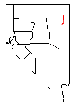
The Toano Range is a mountain range located in eastern Elko County, Nevada in the United States. The highest point in the range reaches 7,913 feet (2,412 m). The range is separated from the Goshute Mountains to the south by Morgan Pass.

The Goshute Mountains is a mountain range in southeastern Elko County, Nevada, United States.
Interstate 80 (I-80) traverses the northern portion of the U.S. state of Nevada. The freeway serves the Reno–Sparks metropolitan area and passes through the towns of Fernley, Lovelock, Winnemucca, Battle Mountain, Carlin, Elko, Wells and West Wendover on its way through the state.

Oasis is a census-designated place (CDP) located in eastern Elko County, Nevada, United States, at the junction of State Route 233 and Interstate 80, 31 miles (50 km) northwest of the Utah border and 77 miles (124 km) east of Elko. As of the 2008 American Community Survey it had a population of 34.

Baiso is a comune (municipality) in the Province of Reggio Emilia in the Italian region Emilia-Romagna, located about 60 kilometres (37 mi) west of Bologna and about 20 kilometres (12 mi) south of Reggio Emilia.
Carpineti is a comune (municipality) in the Province of Reggio Emilia in the Italian region Emilia-Romagna, located about 70 kilometres (43 mi) west of Bologna and about 30 kilometres (19 mi) southwest of Reggio Emilia.
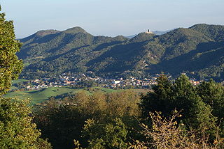
Toano is a comune (municipality) in the Province of Reggio Emilia in the Italian region Emilia-Romagna, located about 60 kilometres (37 mi) west of Bologna and about 35 kilometres (22 mi) south of Reggio Emilia.
Palagano is a comune (municipality) in the Province of Modena in the Italian region Emilia-Romagna, located about 60 kilometres (37 mi) southwest of Bologna and about 45 kilometres (28 mi) southwest of Modena. As of 31 December 2004, it had a population of 2,455 and an area of 60.4 square kilometres (23.3 sq mi).
Prignano sulla Secchia is a comune (municipality) in the Province of Modena in the Italian region Emilia-Romagna, located about 50 kilometres (31 mi) west of Bologna and about 30 kilometres (19 mi) southwest of Modena. It is in the Modenese Appennines, in the valley of the Secchia river.

Cherry Creek is a historic mining town located in northern White Pine County, in northeastern Nevada in the western United States. It is a census county division (CCD), with a population at the 2010 census of 72.
A chonolith is an igneous rock intrusion of irregular shape. A chonolith has a demonstrable base, which is absent in other types of irregularly shaped intrusions.

Morsiano is a hamlet administratively a frazione of Villa Minozzo in the province of Reggio Emilia. Located in the tuscany-emilia apennines near the Mount Cusna slopes. It is about 720 meters above sea level.
The Mountain States form one of the nine geographic divisions of the United States that are officially recognized by the United States Census Bureau. It is a subregion of the Western United States.

Pequop or Pequop Siding is a ghost town in Elko County, Nevada, United States. It was located west of Toano on the route around the north end of the Pequop Mountains between Cobre and Wells. It was first a stop station of the Central Pacific Railroad and later a non-agency station on the Southern Pacific Railroad. Several buildings were erected to house section crews.

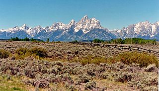
Toano is a ghost town in Elko County, Nevada, in the United States.