Related Research Articles

Benin, a narrow, key-shaped, north–south strip of land in West Africa, lies between the Equator and the Tropic of Cancer. Its latitude ranges from 6°30′ N to 12°30′ N and its longitude from 1° E to 3°40′ E. It is bounded by Togo to the west, Burkina Faso and Niger to the north, Nigeria to the east, and the Bight of Benin to the south.

The Wright Valley is a large east–west trending valley, formerly occupied by a glacier but now ice free except for Wright Upper Glacier at its head and Wright Lower Glacier at its mouth, in Victoria Land, Antarctica. It was named by the VUWAE (1958-59) for Sir Charles Wright, for whom the BrAE (1910-13) named the glacier at the mouth of this valley.
Hobbs Coast is that portion of the coast of Marie Byrd Land, Antarctica extending from Cape Burks to a point on the coast opposite eastern Dean Island, at 74°42′S127°05′W, or between the Ruppert Coast in the west and the Bakutis Coast in the east. It stretches from 136°50′W to 127°35′. The coast was discovered by the US Antarctic Service (1939–1941) and named for Professor William H. Hobbs of the University of Michigan, a glaciologist specializing in polar geography and history. The United States Geological Survey completely mapped the coast from ground surveys and U.S. Navy air photos, 1959–1965.

Mogtédo, also spelt Mogtedo or Moktedo, is a town located in the province of Ganzourgou in Burkina Faso. The population of Mogtédo is 25,699, and it is the capital of Mogtédo Department.
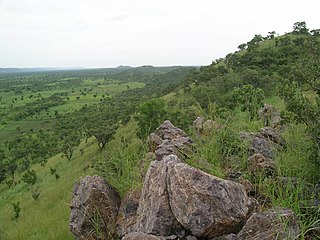
The Togo Mountains is a mountain range which stretches across the central region of the West African country of Togo and across the eastern and western borders of that country into Ghana and Benin. In Ghana, the range is also known as the Akwapim Hills, and in Benin it is also known as the Atakora Mountains. Part of the range is associated with the country of Niger, where the W National Park is found. The African wild dog, Lycaon pictus, was historically found in this region but may now be extirpated from this locale.
The Allan Hills are a group of hills, mainly ice free and about 12 nautical miles long, lying just north-west of the Coombs Hills near the heads of Mawson Glacier and Mackay Glacier in the Oates Land and Victoria Land regions of Antarctica.

Oquillas is a municipality and town located in the province of Burgos, Castile and León, Spain. According to the 2022 census (INE), the municipality has a population of 51 inhabitants.

Villanubla is a municipality located in the province of Valladolid, Castile and León, Spain. According to the 2018 census (INE), the municipality has a population of 2,692 inhabitants.

Bassar Prefecture is one of the prefectures of Togo and is located in Kara Region in Togo. The cantons of Bassar include Bassar, Kabou, Bitchabé, Dimouri, Sanda-Kagbanda, Bangéli, Baghan, Sanda-Afowou, Manga, and Kalanga. At the time of the 2022 census it had a population of 152,065 people.
The Mariner Glacier is a major glacier over 60 nautical miles long, descending southeast from the plateau of Victoria Land, Antarctica, between Mountaineer Range and Malta Plateau, and terminating at Lady Newnes Bay, Ross Sea, where it forms the floating Mariner Glacier Tongue.
Jiunjiunde is a village in the Bassar Prefecture in the Kara Region of north-western Togo.
Ségou is a village in Togo.
Gaffati is a village and rural commune in the Mirriah Department of the Zinder Region of Niger. As of 2012, it had a population of 46,379.
Tamaske is a city and rural commune in Niger. It is located in the Keita Department, in the Tahoua Region.
Hiremele is a village in Belgaum district in the southern state of Karnataka, India.
The Eidshaugane Peaks are a group of peaks 1 nautical mile north of Eidsgavlen Cliff in the Humboldt Mountains of Queen Maud Land, Antarctica.
Lambussie is a small town and is the capital of Lambussie Karni district, a district in the Upper West Region of north Ghana.

Machermo is a small village in the Khumbu region of eastern Nepal. It lies in the Dudh Kosi River valley just north of Dole and south of Gokyo at an altitude of 4470m, just below the terminal moraine of the Ngozumpa glacier, the longest glacier in the Himalayas.

Bombay Castle, also known in Vietnamese: Đá Ba Kè; Mandarin Chinese: 蓬勃堡; pinyin: Péngbó Bǎo; Abad Santos Shoal, is a reef with a lighthouse in the Rifleman Bank of the southern Spratly Islands. It is occupied by Vietnam, but also claimed by China (PRC) and Taiwan (ROC).
Chaukune is a rural municipality located in Surkhet District of Karnali Province of Nepal.
References
- ↑ indexmundi map of Toguen, Togo. (See External Links)