
The Tonga Trench is an oceanic trench located in the southwestern Pacific Ocean. It is the deepest trench in the Southern hemisphere and the second deepest on Earth after the Mariana Trench. The fastest plate-tectonic velocity on Earth is occurring at this location, as the Pacific Plate is being subducted westward in the trench.

Tongatapu is the main island of Tonga and the site of its capital, Nukuʻalofa. It is located in Tonga's southern island group, to which it gives its name, and is the country's most populous island, with 74,611 residents (2016), 70.5% of the national population, on 260 square kilometres. Based on Google Earth Pro, its maximum elevation is at least 70 metres above sea level along Liku Road at 21 degrees 15 minutes and 55.7 seconds south 175 degrees 08 minutes 06.4 seconds west, but could be even higher somewhere else. Tongatapu is Tonga's centre of government and the seat of its monarchy.

The Brothers is a group of small islands in Cook Strait, New Zealand, off the east coast of Arapaoa Island.

Haʻapai is a group of islands, islets, reefs, and shoals in the central part of Tonga. It has a combined land area of 109.30 square kilometres (42.20 sq mi). The Tongatapu island group lies to its south, and the Vavaʻu group lies to its north. Seventeen of the Haʻapai islands are inhabited. Their combined population is 5,419. The highest point in the Ha‘apai group, and in all of Tonga, is on Kao, which rises almost 1,050 metres (3,440 ft) above sea level.

ʻEua[ʔe.ˈu.a] is an island in the kingdom of Tonga. It is close to Tongatapu, but forms a separate administrative division. It has an area of 87.44 km2 (33.76 sq mi), and a population in 2021 of 4,903 people.

Metis Shoal, also known as Lateiki Island, is a volcanic island at the top of a submarine volcano in Tonga, located between the islands of Kao and Late. The current island formed in October 2019, when a smaller island disappeared after 24 years.
Foa is an island in Tonga. It is located within the Haʻapai group in the centre of the country, to northeast of the national capital of Nukuʻalofa.
Hakauata is an island in Tonga. It is located within the Ha'apai Group in the center of the country, to northeast of the national capital of Nukuʻalofa.

Lifuka is an island in the Kingdom of Tonga. It is located within the Haʻapai Group in the centre of the country, to northeast of the national capital of Nukuʻalofa.
Lofanga is an island in Tonga. It is located within the Ha'apai Group in the centre of the country, to northeast of the national capital of Nukuʻalofa. The island had a population of 137 at 2016, and an area of 1.45 km2.

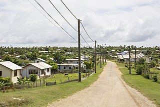
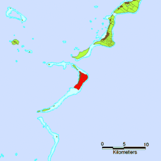
Haʻano is an island in the Haʻapai islands of Tonga. To the south are the islands of Foa and Lifuka.
ʻUiha is an island in Lifuka district, in the Haʻapai islands of Tonga. It had a population of 638 in 2006 and an area of 5.36 km2 (2.07 sq mi). The island has two villages, ʻUiha and Felemea.
Kito is an island in the Lulunga district, part of the Ha'apai islands of Tonga.

Tungua is an island in Lulunga district, in the Ha'apai islands of Tonga. The island had a population of 187 in 2016.
Muitoa is a settlement in Ha'ano island, Tonga. It had a population of 53 in 2016.
Tatafa is an islet which belongs to ʻUiha island, Tonga. It is located within the Ha'apai Group.
Taʻanga is a village on the island of ʻEua in Tonga. It is located on the western side of the island, just north of 'Ohonua. The population is 207.
