
Guam is an organized, unincorporated territory of the United States in Micronesia in the western Pacific Ocean. It is the westernmost point and territory of the United States. The capital city of Guam is Hagåtña, and the most populous city is Dededo. Guam has been a member of the Pacific Community since 1983. The inhabitants of Guam are American citizens by birth. The indigenous Guamanians are the Chamorros, who are related to other Austronesian peoples of Indonesia, the Philippines, Taiwan, Micronesia, and Polynesia.

Hagåtña is the capital village of the United States territory of Guam. From the 18th through mid-20th century, it was Guam's population center, but today it is the second smallest of the island's 19 villages in both area and population. However, it remains one of the island's major commercial districts in addition to being the seat of government.

The Seal of Guam appears in the middle of the United States territory of Guam. It depicts Agaña Bay near Hagåtña, a local proa and a palm tree. Charles Alan Pownall approved the seal in 1946. It depicts a coconut palm on the shore with a sailboat nearby on the water. The name "Guam" appears in red across the center of the seal.

The Guam national football team represents Guam, overseas territory of the United States in international football and is controlled by the Guam Football Association. They are affiliated with the Asian Football Confederation's East Asian Football Federation region.

Yona is a village in the United States territory of Guam.

Cocos Island is an island 1 mile (1.6 km) off the southern tip of the United States territory of Guam, located within the Merizo Barrier Reef, part of the municipality of Merizo. The island is uninhabited, 1,600 meters (5,200 ft) long in a southwest-northeast direction, between 200 m (660 ft) and 300 m (980 ft) wide, and has an area of 386,303 m2. It sits atop the southwestern coral reef rim of Cocos Lagoon.

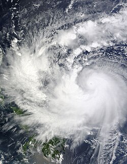
Typhoon Pongsona was the last typhoon of the 2002 Pacific typhoon season, and was the second costliest United States disaster in 2002, only behind Hurricane Lili. The name "Pongsona" was contributed by North Korea for the Pacific tropical cyclone list and is the Korean name for the garden balsam. Pongsona developed out of an area of disturbed weather on December 2, and steadily intensified to reach typhoon status on December 5. On December 8 it passed through Guam and the Northern Mariana Islands while near its peak winds of 175 km/h. It ultimately turned to the northeast, weakened, and became extratropical on December 11. Typhoon Pongsona produced strong wind gusts peaking at 290km/h, which left the entire island of Guam without power and destroyed about 1,300 houses. With strong building standards and experience from repeated typhoon strikes, there were no fatalities directly related to Pongsona, although there was one indirect death from flying glass. Damage on the island totaled over $730 million, making Pongsona among the five costliest typhoons on the island. The typhoon also caused heavy damage on Rota and elsewhere in the Northern Mariana Islands, and as a result of its impact the name was retired.
Fofos is a small island off the southern coast of the island of Guam. It is connected to the mainland by the Merizo Barrier Reef.

The following is an alphabetical list of articles related to the United States Territory of Guam.
The Ramu languages are a family of some thirty languages of Northern Papua New Guinea. They were identified as a family by John Z'graggen in 1971 and linked with the Sepik languages by Donald Laycock two years later. Malcolm Ross (2005) classifies them as one branch of a Ramu – Lower Sepik language family. Z'graggen had included the Yuat languages, but that now seems doubtful.
Typhoon Parma, known in the Philippines as Typhoon Pepeng, was the second typhoon to affect the Philippines within the span of a week during September 2009.

Talofofo is a village located in the southern part of the United States territory of Guam, on the east coast. The village center is located in the hills above the coast, while the smaller coastal community below the cliff is known as Ipan.
The Tamolan languages are a small family of clearly related languages spoken in the region of the Guam River in Madang Province, Papua New Guinea.

Typhoon Alice was a typhoon that bought severe flooding to Guam during the 1953 Pacific typhoon season. The system was first tracked near the Marshall Islands on October 11 by the Joint Typhoon Warning Center (JTWC) as a tropical storm, and the Japan Meteorological Agency (JMA) as a tropical depression. JMA upgraded Alice to a tropical storm east of Guam on October 14, and JTWC reported that the storm had intensified to 65 knots, equivalent to a Category 1 typhoon on the Saffir–Simpson scale, one day later. Northwest of Guam, the typhoon traveled northeastwards, reaching its peak of 100 kn late on October 18 near Iwo Jima. Alice then steadily weakened, down to a tropical storm on October 20. The storm became extratropical on October 23 near the International Date Line, and both agencies ceased tracking the cyclone.

The Guam River is a river in northern Papua New Guinea.

Guam confirmed its first case of the COVID-19 pandemic on March 15, 2020, and the first death on March 22. The Government of Guam ordered the general lockdown of the island in mid-March. Governor Lou Leon Guerrero announced the implementation of a four-step "Pandemic Condition of Readiness" (PCOR) on April 30, 2020. Travelers to Guam from designated high-risk areas must provide a recent negative COVID-19 test or undergo mandatory quarantine in a government-approved facility. Guam moved from PCOR 1 to PCOR 2 on May 10, allowing some business activity with restrictions, and then to PCOR 3 on July 20. A spike in cases in mid-August resulted in the rolling positivity rate for tests to go above 2%, as well as infections for both the Governor and Lieutenant Governor. Guam announced a return to the lockdown conditions of PCOR 1 on August 14 for at least two weeks to control the outbreak.
