
Bhojpur is one of the two urban municipalities of Bhojpur District of Province No. 1 of Nepal.
Bajura District, a part of Sudurpashchim Province, is one of the seventy-seven districts of Nepal. The district, with Martadi as its district headquarters, covers an area of 2,188 km2 (845 sq mi) and had a population of 108,781 in 2001 and 134,912 in 2011.
Kohalpur is a municipality in Banke District of Lumbini province of Nepal. The municipality was established on 18 May 2014 merging the existing two Village Development Committees i.e. Rajhena and Kohalpur. The town is in East-West highway and one of the fastest developing places in Nepal. A neighboring city Nepalgunj is on South (16 km [9.9 mi]), with Ghorahi city (135 km [84 mi]) to west in Dang District and towards south further 6 km (3.7 mi) is the Indian border. In fact it is a growing city in the western region of Nepal. It has a junction to diverse the roadway transport to east, west, north and south from the city.
Siraha is the headquarters and municipality of Siraha District, a part of Madhesh Province, Nepal. Siraha had a population of 28,442 according to the census of 2011. and a population of 82,531 as of 2015. The current population of Siraha municipality as of census 2022, is 96,543. It has a male population of 47,306 and female population of 49,237. The present mayor of Siraha Municipality is Dr. Nabin Kumar Yadav and Deputy Mayor is Babita Kumari Sah. Both assumed office on 25 May 2022. His predecessor mayor was Asheswor Yadav and the deputy mayor was Dr. Namita Yadav. Both assumed office on 25 September 2017 and their last working day was on 24 May 2022. The town is at 80 metres (260 ft) altitude, 29 kilometres (18 mi) ESE of Janakpur.
Budhiganga Municipality is the newly formed municipality in Bajura District in the Sudurpashchim Province of Nepal. It was formed in March, 2017 as decided by the Cabinet in line with the Constitution of Nepal 2015, recommended by the Local Bodies Restructuring Commission (LBRC).
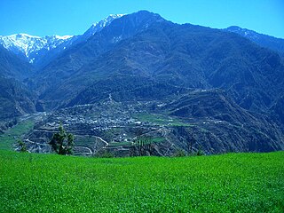
Chhatara is a village in Bajura District in the Seti Zone of north-western Nepal, It lies in Ward No. 1 of Triveni Municipality.
Kailashmandau used to be VDC in Bajura District in the Seti Zone of north-western Nepal. At the time of the 2011 Nepal census it had a population of 9,586 and had 1818 houses. There is a small market and it is also the junction to many villages of this region.
Bungkot, formerly known as Bungkot VDC, currently falls under Shahid Lakhan Rural Municipality ward 7 and ward 8 as Nepal entered in Federalism since 2015. Former Bungkot VDC that was structured with 9 wards as their administrative division is now merged to two wards of Shahid Lakhan Rural Municipality. Previous 1,2,3,4 wards of Bungkot VDC now falls in ward 7 of Shahid Lakhan Rural Municipality, whose administrative center is Kahbdi-bhanjyang. Whereas, previous 5,6,7,8,9 wards now falls in ward 8 of the Rural Municipality, whose administrative center is Mailung.
Sangrumba साङरुम्बा is a town and Village Development Committee in Ilam District in the Province No. 1 of eastern Nepal. At the time of the 1991 Nepal census it had a population of 4,607 persons living in 839 individual households. According to the VDC report of 2068 BS, the total population was 6,288 and the total number of households was 1,227, an average of 5.12 members per household.
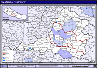
Pindikhola was a village development committee in Syangja District in the Gandaki Zone of central Nepal. At the time of the 2011 Nepal census it had a population of 4,956 people living in 1,119 individual households.

Previously Ugarachandi Nala was a village development committee located in Kavrepalanchok District of Nepal. It is named after the temple of goddess Ugrachandi Bhagawati located in Nala Bazaar. But now in the year 2017 AD it has been changed and divided into ward no. 3 and 4 of Banepa municipality. According to the 1991 Nepal census, the population of the VDC is 6,327 in 1,035 individual households.
Bardaghat नेपाली: बर्दघाट is a Municipality in Nawalparasi District in Lumbini Province, Nepal. It is situated in the lap of the Chure range. This municipality was established on 18 May 2014 by merging existing Makar and Panchanagar Village Development Committees (VDCs). Again during the local election, the neighbouring VDC Dawanne devi and some parts of Dhurkot, Jamuniya, and Rupauliya were merged. It has a population of 76,703 with an area of 162.05 km2. The annual population growth rate is 2.77%. It has a literacy rate of 82.05%. It is an emerging town of Nawalparasi District that is developing rapidly with tourist areas.
Sundar Haraicha is a municipality in Morang District of Koshi Province in Nepal. It is centered around Biratchowk town which is the gateway to Biratnagar. It borders Itahari Sub- Metropolitan city to the west, Dharan Sub- Metropolitan city to the Northwest and Belbari municipality to the east and is connected by Mahendra Highway. It is one of the fastest growing cities in eastern Nepal and the second largest city of Morang district after Biratnagar, with 121,305 inhabitants living in 26,677 households. It consists of the town centres of Biratchowk and Gothgaun which are parts of the Greater Birat Development Area which incorporates the cities of Biratnagar-Itahari-Gothgau-Biratchowk-Dharan primarily located on the Koshi Highway in Eastern Nepal, with an estimated total urban agglomerated population of 804,300 people living in 159,332 households.
Pacharauta is a municipality in Bara District in Province No. 2 of South-Eastern Nepal. It was formed in 2016 occupying current 9 sections (wards) from previous 9 former VDCs. It occupies an area of 44.01 km2 with a total population of 34,175.

Badimalika Municipality is a newly formed municipality in Bajura District in the Sudurpashchim Province of Nepal. It was formed in March, 2017 as decided by the Cabinet in line with the Constitution of Nepal 2015
Budhinanda Municipality is the newly formed municipality in Bajura District in the Sudurpashchim Province of Nepal. It was formed in March 2017 in line with the Constitution of Nepal 2015 as per the requirement of Ministry of Federal Affairs and General Administration. The name of this municipality is originated after the name of temple and pound Budhinanda.

Triveni is a municipality in Bajura district in the Sudurpashchim Province of Nepal. It was formed in March 2017 as decided by the Cabinet in line with the Constitution of Nepal 2015, recommended by the Local Bodies Restructuring Commission (LBRC).
Himali is a rural municipality in Bajura District in the Sudurpashchim Province of Nepal. It was formed in March 2017, when Government of Nepal announced 744 local level units in line with the Constitution of Nepal 2015. It lies in the northern region of Bajura District and is also considered to be the remote place of this district.
Wai used to be a VDC in Bajura District. Now it is the part of Swamikartik Rural Municipality of Sudurpashchim Province, Nepal.
Jukot used to be a VDC in Bajura District. Now it is the part of Swamikartik Rural Municipality of Sudurpashchim Province, Nepal. Now Jukot VDC is ward no. 3 of Swamikartik Rural Municipality. This VDC has 597 household with population of 3,230 of which 1,617 are female and 1,613 are male.People residing here belongs to Chhetri, Kami, Brahmin, Damai, Sarki, Limbu etc. Politically, the Dalit population have been dominated by the Thakuris. It is one of the remote place of Bajura District.
