
A chocolate chip cookie is a drop cookie that originated in the United States and features chocolate chips or chocolate morsels as its distinguishing ingredient. Circa 1938, Ruth Graves Wakefield added chopped up bits from a Nestlé semi-sweet chocolate bar into a cookie.

State Route 91 (SR 91) is a major east–west state highway in the U.S. state of California that serves several regions of the Greater Los Angeles urban area. A freeway throughout its entire length, it officially runs from Vermont Avenue in Gardena, just west of the junction with the Harbor Freeway, east to Riverside at the junction with the Pomona and Moreno Valley freeways.

FasTrak is the electronic toll collection (ETC) system used in the state of California in the United States. The system is used statewide on all of the toll roads, toll bridges, and high-occupancy toll lanes along the California Freeway and Expressway System.

Ruth Graves Wakefield was an American chef, best known as the inventor of the Toll House Cookie, the first chocolate chip cookie. She was also a college graduate, dietitian, educator, business owner, and author.

The Spaniards Inn is an historic pub on Spaniards Road between Hampstead and Highgate in London, England. It lies on the edge of Hampstead Heath near Kenwood House. It is a Grade II listed building, dating back to the 16th century.

Ffridd Gate was a station on the Corris Railway in Merioneth, Wales, UK. It was built at the level crossing over the B4404 road to Llanwrin, near the hamlet of Fridd. A small hamlet also grew up around the station and a nearby (pre-existent) toll-house. The hamlet and former station are near to the confluence of the Afon Dulas and the River Dyfi, around 2 1⁄4 miles (3.6 km) west of the village of Llanwrin and 1 mile (1.6 km) north of the town of Machynlleth.

Turnpike trusts were bodies set up by individual acts of Parliament, with powers to collect road tolls for maintaining the principal roads in Britain from the 17th but especially during the 18th and 19th centuries. At the peak, in the 1830s, over 1,000 trusts administered around 30,000 miles (48,000 km) of turnpike road in England and Wales, taking tolls at almost 8,000 toll-gates and side-bars.

Green Valley Lake is an unincorporated community in San Bernardino County, California. It has a population of about 300. The ZIP Code is 92341 and the community is inside area code 909.

Tollhouse is an unincorporated community in Fresno County, California. It lies at an elevation of 1,919 feet (585 m). Tollhouse is located in the Sierra Nevada, 7 miles (11 km) southwest of Shaver Lake and 18 miles southwest of Huntington Lake. It is home to 2,089 people.

A tollhouse or toll house is a building with accommodation for a toll collector, beside a tollgate on a toll road or canal.
U.S. Route 40 enters Pennsylvania at West Alexander. It closely parallels Interstate 70 (I-70) from West Virginia until it reaches Washington where it follows Jefferson Avenue and Maiden Street. In Washington, US 40 passes to the south of Washington & Jefferson College. Following Maiden Street out of town, the road turns southeast toward the town of California. A short limited access highway in California and West Brownsville provides an approach to the Lane Bane Bridge across the Monongahela River. From here, the road continues southeast to Uniontown.
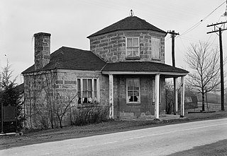
The Searights Tollhouse of the National Road is a historic toll house on United States Route 40, the former route of the historic National Road, north of Uniontown, Pennsylvania. Built in 1835, it is one of two surviving tollhouses built by the state of Pennsylvania to collect tolls along the portion of the road that passed through that state. It has been restored by the state and is now maintained by the local historical society. It was declared a National Historic Landmark in 1964.
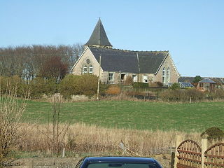
Clola is a hamlet in Buchan, Aberdeenshire, Scotland. Clola is situated on the A952 road. There is considerable evidence of local habitation by early man in the vicinity of Clola. Some of these nearby human traces are evident in Catto Long Barrow, a massive stone structure now surrounded by agricultural fields.
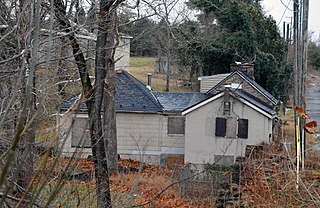
The Petersburg Tollhouse, now located in the hamlet of Addison, Pennsylvania, United States, was the first tollhouse that travelers encountered while on the National Road heading west into Pennsylvania. The Old Route 40 now sits atop the National Pike at this tollhouse. The Petersburg tollhouse is one of three surviving tollhouses for the National Pike; the remaining ones are the LaVale tollhouse located between Cumberland and Frostburg, Maryland and the Searight's tollhouse located just west of Uniontown on Route 40.

A high-occupancy toll lane is a type of traffic lane or roadway that is available to high-occupancy vehicles and other exempt vehicles without charge; other vehicles are required to pay a variable fee that is adjusted in response to demand. Unlike toll roads, drivers have an option to use general purpose lanes, on which a fee is not charged. Express toll lanes, which are less common, operate along similar lines, but do not exempt high-occupancy vehicles.

Bear Mountain Bridge Road is a three-mile (4.8 km), two-lane section of US 6/US 202 from the west approach to Bear Mountain Bridge to a former toll house in the Town of Cortlandt, New York, United States. Local residents sometimes refer to the road as the Goat Trail. It winds around the steep, rocky slopes of Anthony's Nose, the southernmost peak of the Hudson Highlands on the east side of the Hudson River. In its first mile from the junction with NY 9D it climbs 200 feet (61 m) to a scenic overlook that looks out over Iona Island, Dunderberg Mountain, the city of Peekskill and the Charles Point power plant. There are interpretive displays on the history of the area during the Revolutionary War, where the Hudson River Chain was deployed and the Battle of Forts Clinton and Montgomery was fought.

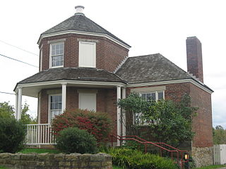
Columbia Turnpike-West Tollhouse is a historic tollhouse located at Greenport in Columbia County, New York. It was built about 1800 and is a 2 1⁄2-story, three bay square limestone building with a medium pitched gable roof. It operated along the Columbia Turnpike and served as the tollkeeper's residence and in use as such until 1907, when the road was turned over to the county and then the state. The state designated the road as New York State Route 23 until that route was realigned southwest towards the Rip Van Winkle Bridge in the 1950s and the segment along the toll house was redesignated as New York State Route 23B.
The Broad Run Bridge and Tollhouse were built for the Leesburg Turnpike Company in Loudoun County, Virginia. The stone bridge, built about 1820, was a permanent replacement for a series of wood bridges at the location, with at least three that had been washed away between 1771 and 1803. The bridge spanned Broad Run on two arches with prominent conical buttresses. The road rose to the center of the bridge. The stone toll house stands nearby. It is a one-story three-bay house that has been progressively enlarged. The Tollhouse was purchased by the county Board of Supervisors with intentions to restore the facility.

Columbia Turnpike-East Tollhouse is a 1799-built toll house along New York State Route 23 east of Mitchell Street and Mansfield Road in the Town of Hillsdale, New York. It operated along the Columbia Turnpike until 1907 when it was turned over to the county and then the state, which designated the road as New York State Route 23. The house served as a private residence until 1990.

In the 19th century small tollkeeper's cottages were built to house tollkeepers who collected tolls on the roads that lead into the city later known as Toronto, Ontario. Private companies were licensed to maintain the province's roads, and they were allowed to levy tolls from those traveling on the road to pay for that maintenance. Tollkeepers were provided with cottages, so they could work from home.