The use of trains of boats to move bulk products has a long history. In the 1760s, the last Duke of Bridgewater developed the Navigable Levels at Worsley, which were a series of underground navigable tunnels serving coal workings. They were linked to the Bridgewater Canal, and two sizes of boats were used both underground and on the canal. 'M' boats were 53 by 6 feet (16.2 by 1.8m) and carried 10 tons of coal, while 'T' boats were 50 by 4.5 feet (15.2 by 1.4m) and carried 7 tons. They were pointed at both ends, as they could not be turned below ground, and were made up into trains of six to ten for transfer along the canal to Manchester.[2] More similar to Bartholomew's eventual design were the tub boats used on the Shropshire Tub Boat Canals, which were rectangular and 20 by 6.3 feet (6.1 by 1.9m). Tubs on the Ketley Canal carried 8 tons, but those on the Shropshire Canal were not as deep, and carried 5 tons. The locks on the Shrewsbury Canal were designed so that four tubs could fit into them, and although Thomas Telford, the engineer for the canal, stated that the locks had intermediate gates so that one, three or four tubs could use them, there is no evidence that the middle gates were ever fitted.[3]
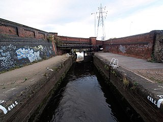
The Aire and Calder Canal Company opened the broad canal from Knottingley to Goole which was designed to circumvent the difficult lower reaches of the River Aire in 1826.[4] They had been experimenting with steam-powered boats since 1813, and had introduced steam paddle tugs in 1831. Thomas Hamond Bartholomew, the canal company's engineer, was also experimenting with a steam-powered fly boat in 1852, but died later that year. The post of chief engineer was then given to his son, William Hamond Bartholomew, who continued to innovate. He introduced two types of tugs, both of which used propellers, rather than paddles, and the larger type was able to tow ten keels, carrying a total of 700 tons of cargo. Problems were experienced at locks, where the keels had to be worked through individually, and so in 1859, Bartholomew decided to lengthen the locks so that the trains of boats could pass through more easily. Pollington lock was lengthened to 206 feet (63m) in October 1860, and Whitley, Bulholme, Ferrybridge and Castleford locks followed. The stage was now set for Bartholomew's next major innovation.[5]
Development
On 20 May 1861, Bartholomew met with Mr. Wilson and Mr. Warde-Aldam, the company chairman, and they discussed the possibility of using iron compartments, which would be filled with coal, and emptied by a hoist at Goole. Bartholomew thought that a compartment holding 30 tons would be ideal, although Warde-Aldam recommended 25 tons. The plan was to use six compartments, sandwiched between a bow and a stern compartment, which would be towed like a conventional boat. The hoist would be hydraulic, and they were already considering the introduction of hydraulic power at Goole to operate the locks. On 20 December 1861, a board meeting authorised the expenditure of £13,382, which would include three 'train boats' costing £1,100 each, a hoist at £2,500, and the hydraulic equipment to operate both the lock and the hoist.[6]
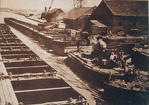
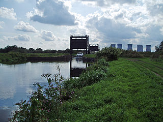
Tom Pudding hoist at Goole
By the time Bartholomew had obtained a patent on 7 February 1862, the plans had developed somewhat, as the design now included a steam-powered pusher tug instead of the stern compartment, and included chains which ran the length of the train to enable it to be steered. He had no idea how the boat would behave when afloat, and so the detailed design work was given to Hudswell and Clarke of Leeds, while the design of the hoist was the responsibility of William Armstrong and Co. Ltd. The original plan was to use doors in the side of the compartment to unload the coal, which would require it to be hoisted some 35 feet (11m) upwards to allow the coal to discharge into a coaster. Although Hudswell and Clarke may have built one compartment with side doors, and several designs were contemplated, the engineer at Armstrong's suggested that a better solution would be to raise the compartments in a cage, which could then be tipped right over, so that the coal was emptied out of the top of the boat. This they thought would only require the compartment to be raised by 25 feet (7.6m), and so the hoist would be cheaper to build. By September 1863, the Aire and Calder had taken delivery of six compartments and a stern tug, but the bow section was missing, and construction of the hoist had not begun. Warde-Aldam expressed some concern, as the handling of such a boat was still unknown.[7]
Warde-Aldam's fears were unfounded, as by the end of the year trials with the complete boat were sufficiently successful that an order was placed for more units. Each tug and bow section would have three sets of six compartments, so that one could be loading, one unloading, and the third could be in transit. Steering of the boat was controlled by the chains running down both sides of the assembly, which were connected to two steam-operated pistons on the tug. In order to keep the compartments in line, each had a projecting stem post, which fitted into a recess in the back of the next compartment. The hoist was eventually tested on 4 February 1864, and full trials began in August of that year. Operation of the hoist was deficient, and the two small hydraulic cylinders which powered it were replaced by one much larger one. Subsequent hoists had two large cylinders, and the hydraulic pressure was increased from 750 pounds per square inch (52bar) to 825 pounds per square inch (56.9bar) and finally 900 pounds per square inch (62bar). Having handled 1,198 tons of coal during the trials, the system was operational by the beginning of 1865.[8]
Operation
Diagram of Bartholomew's sectional boat, based on 1862 patent and revised steering mechanism of 1866
Although the design was for six compartments per train, it was found that seven could fit through the locks, and so the trains were lengthened. The compartments were made deeper after the first 19 had been built, so that they could carry 30 tons each, rather than 25. The new design was found to be more stable, and a train now held 210 tons of coal. It took between eight and twelve hours to travel from the colliery at Stanley Ferry to Goole, a distance of around 30 miles (48km), and three and a half hours to unload the compartments, but the trains were often delayed at Goole for two or three days before they could be unloaded, and at the colliery, trains could be delayed for up to 13 days before they were loaded. In order to operate a train, a crew of four men were needed, consisting of a captain, a mate, an engineer and a stoker.[9]
Experience proved that a train of seven compartments was the longest that could be controlled. While it was possible to push ten or eleven compartments, they became difficult to steer when empty, and particularly if it was windy. In the 1870s, the number of compartments was increased to four trains of seven per tug, but as the numbers available increased, the concept of a fixed train gave way to the compartments being considered individually, and a train could be made up from any that were available. The tugs had a water tank near the bow, which could be filled or emptied to alter the angle of the tug depending on whether it was pushing a train of full or empty compartments. When Bartholomew presented evidence to the Select Committee On Canals in 1883, he indicated that trains often exceeded 11 compartments, and that in this configuration, the tug pulled the compartments. At the time, many trains consisted of 11 or 12 compartments, but trains of 22 were quite frequent, and up to 30 had been tried. Spring buffers had been added between the compartments, to assist the straightening of the boat after it had negotiated a bend in the canal. The navigation company hoped to extend the locks by another 250 feet (76m) to allow the longer trains to pass without having to split them,[10] but there is no evidence that this programme was carried out, as the normal length of a train was still 10 or 11 compartments in 1904.[11]
When the system had been operating for six years, Bartholomew approached the directors, and pointed out that although such a system had not been tried before, it had been completely successful, and he had not wasted any money on abortive alterations. All changes had been made as a result of actual experience. The directors recognised his competence, and awarded him a bonus of £1,000, and a payment of £220 for the models which he had made. As a result, he allowed the canal company to freely use his patent.[12] Bartholomew went on to become General Manager of the Canal Company as well as Chief Engineer from 1875.[13]
After the first world war, the length of the locks between Goole and Castleford was increased to over 450 feet (140m), which allowed trains of 19 compartments with a leader and tug to work through them without being split. A leader, known as a "Jebus", was still used as the pointed bow ensured that the water from the tug's propeller was directed downwards and under the train, rather than hitting the vertical end of the first compartment. Above Castleford, such trains had to be split. Experiments were also made with much longer trains below Castleford, and as many as 38 compartments were coupled together.[14][15]
Mechanisation
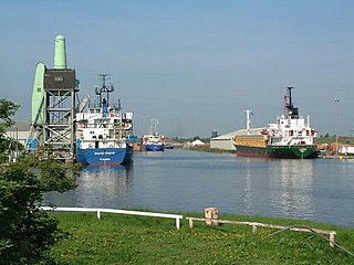
The key to the success of the system was the mechanisation of the transshipments. In the docks at Goole, the large boat hoists could lift the Puddings and discharge them directly into seagoing ships which exported the coal to all parts of the world. One of the five hoists has been preserved.
At the colliery the containers were mounted on waggons so that they could be taken into the heart of the colliery and the coal loaded directly from the pit head. In 1891, an inclined plane was installed at Stanley Ferry[16] to connect the colliery directly to the canal. The 15-foot (4.6m) wide compartments carrying 35 tons of coal were balanced on standard gauge railway wagons. Despite the precarious nature of this operation, no accidents were recorded.[17] Because of the success of the system, by 1913 there were over 1,000 Tom Puddings in use and they were transporting 1,500,000 long tons (1,700,000 short tons; 1,500,000t) of coal per year, which compares well with Warde-Aldam's original estimate of 45,000 tons per year.[7]
A similar system was developed when the Kellingley Colliery opened at Knottingley. The Hargreave barge system was used to transport coal to the power station at Ferrybridge. The configuration consisted of three coal pans, each 56 by 9.25 feet (17.07 by 2.82m) and 9.5 feet (2.9m) deep, capable of carrying 170 long tons (190 short tons; 170t) of coal. With a pusher tug at the rear, the train was 195 feet (59m) long. The pans were, however, rigidly connected to each other, unlike Bartholomew's flexible arrangement.[18][19]
Related Research Articles
The Aire and Calder Navigation is the canalised section of the Rivers Aire and Calder in West Yorkshire, England. The first improvements to the rivers above Knottingley were completed in 1704 when the Aire was made navigable to Leeds and the Calder to Wakefield, by the construction of 16 locks. Lock sizes were increased several times, as was the depth of water, to enable larger boats to use the system. The Aire below Haddlesey was bypassed by the opening of the Selby Canal in 1778. A canal from Knottingley to the new docks and new town at Goole provided a much shorter route to the River Ouse from 1826. The New Junction Canal was constructed in 1905, to link the system to the River Don Navigation, by then part of the Sheffield and South Yorkshire Navigation.
The Sheffield and South Yorkshire Navigation (S&SY) is a system of navigable inland waterways in South Yorkshire and Lincolnshire, England.
Goole is a port town and civil parish on the River Ouse in the East Riding of Yorkshire, England. The town's historic county is the West Riding of Yorkshire.
The Barnsley Canal is a canal that ran from Barnby Basin, through Barnsley, South Yorkshire, England to a junction with the Aire and Calder Navigation near Wakefield, West Yorkshire. It was built in the 1790s, to provide a transport link from coal reserves at Barnsley to a wider market. Both the Aire and Calder Navigation and the River Don Navigation took a keen interest in the project, the former buying many of the initial shares, and the latter constructing the Dearne and Dove Canal to link the canal to their waterway. Water supply issues meant that the Aire and Calder proposed pumping all of the water for the canal from the River Calder, using steam pumps, but a reservoir was built at Cold Hiendley instead, increasing the construction costs, but reducing the running costs. The canal as built was 14.5 miles (23.3 km) long and included 15 locks.
The canals of the United Kingdom are a major part of the network of inland waterways in the United Kingdom. They have a varied history, from use for irrigation and transport, through becoming the focus of the Industrial Revolution, to today's role of recreational boating. Despite a period of abandonment, today the canal system in the United Kingdom is again increasing in use, with abandoned and derelict canals being reopened, and the construction of some new routes. Canals in England and Wales are maintained by navigation authorities. The biggest navigation authorities are the Canal & River Trust and the Environment Agency, but other canals are managed by companies, local authorities or charitable trusts.
The Dearne and Dove Canal ran for almost ten miles through South Yorkshire, England from Swinton to Barnsley through nineteen locks, rising 127 feet (39 m). The canal also had two short branches, the Worsbrough branch and the Elsecar branch, both about two miles long with reservoirs at the head of each. The Elsecar branch also has another six locks. The only tunnel was bypassed by a cutting in 1840.
The Somerset Coal Canal was a narrow canal in England, built around 1800. Its route began in basins at Paulton and Timsbury, ran to nearby Camerton, over two aqueducts at Dunkerton, through a tunnel at Combe Hay, then via Midford and Monkton Combe to Limpley Stoke where it joined the Kennet and Avon Canal. This link gave the Somerset coalfield access east toward London. The longest arm was 10.6 miles (17.1 km) long with 23 locks. From Midford an arm also ran via Writhlington to Radstock, with a tunnel at Wellow.
The Shrewsbury Canal was a canal in Shropshire, England. Authorised in 1793, the main line from Trench to Shrewsbury was fully open by 1797, but it remained isolated from the rest of the canal network until 1835, when the Birmingham and Liverpool Junction Canal built the Newport Branch from Norbury Junction to a new junction with the Shrewsbury Canal at Wappenshall. After ownership passed to a series of railway companies, the canal was officially abandoned in 1944; many sections have disappeared, though some bridges and other structures can still be found. There is an active campaign to preserve the remnants of the canal and to restore the Norbury to Shrewsbury line to navigation.
The New Junction Canal is a canal in South Yorkshire, England. It is part of the Sheffield and South Yorkshire Navigation (S&SYN), although it was jointly funded by the Aire and Calder Navigation, and was opened in 1905. It links the River Don Navigation and the Stainforth and Keadby Canal with the Aire and Calder Navigation. It is completely straight, and was the last canal built in England for commercial purposes.
The Stainforth and Keadby Canal is a navigable canal in South Yorkshire and Lincolnshire, England. It connects the River Don Navigation at Bramwith to the River Trent at Keadby, by way of Stainforth, Thorne and Ealand, near Crowle. It opened in 1802, passed into the control of the River Don Navigation in 1849, and within a year was controlled by the first of several railway companies. It became part of the Sheffield and South Yorkshire Navigation, an attempt to remove several canals from railway control, in 1895. There were plans to upgrade it to take larger barges and to improve the port facilities at Keadby, but the completion of the New Junction Canal in 1905 made this unnecessary, as Goole could easily be reached and was already a thriving port.
Coalisland Canal is a 7.2-kilometre-long (4.5 mi) canal in County Tyrone, Northern Ireland. Construction of the canal began in 1733, but progress was slow and it was not officially opened until 1787. The canal was built to reduce the cost of transporting coal from the Tyrone coalfields to Dublin. An extension known as "Dukart's Canal" was built to link the coalfields of Drumglass with the head of navigation at Coalisland. It opened in 1777 but was an engineering failure and closed when the main canal opened. After some difficulties with the infrastructure, traffic slowly increased, reaching its peak in 1931. Traffic then declined rapidly, and the canal was abandoned in 1954.
Dukart's Canal was built to provide transport for coal from the Drumglass Collieries to the Coalisland Canal in County Tyrone, Ulster, Ireland. It opened in 1777, and used three inclined planes, rather than locks, to cope with changes in level. There is little evidence that it was ever used, as the planes could not be made to work properly, and they were dismantled in 1787.
The Selby Canal is a 6-mile (9.7 km) canal with 2 locks which bypasses the lower reaches of the River Aire in Yorkshire, England, from the village of West Haddlesey to the town of Selby where it joins the River Ouse. It opened in 1778, and provided the main outlet for the Aire and Calder Navigation until 1826, when it was bypassed by a new cut from Ferrybridge to Goole. Selby steadily declined after that, although traffic to York still used the canal.
The Shropshire Canal was a tub boat canal built to supply coal, ore and limestone to the industrial region of east Shropshire, England, that adjoined the River Severn at Coalbrookdale. It ran from a junction with the Donnington Wood Canal ascending the 316 yard long Wrockwardine Wood inclined plane to its summit level, it made a junction with the older Ketley Canal and at Southall Bank the Coalbrookdale (Horsehay) branch went to Brierly Hill above Coalbrookdale; the main line descended via the 600 yard long Windmill Incline and the 350 yard long Hay Inclined Plane to Coalport on the River Severn. The short section of the Shropshire Canal from the base of the Hay Inclined Plane to its junction with the River Severn is sometimes referred to as the Coalport Canal.
A tub boat was a type of unpowered cargo boat used on a number of the early English and German canals. The English boats were typically 6 m (19.7 ft) long and 2 m (6.6 ft) wide and generally carried 3 long tons to 5 long tons of cargo, though some extra deep ones could carry up to 8 long tons. They are also called compartment boats or container boats.
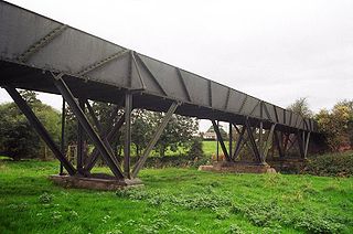
Stanley Ferry Aqueduct was built between 1836 and 1839 to take the Aire and Calder Navigation over the River Calder in West Yorkshire, England. It is one of the earliest through arch bridges in the world and is considered to be the longest span aqueduct executed in cast iron.
The North Pennine Ring is a canal ring which crosses the Pennines between Manchester, Leeds and Castleford. It follows parts of five canals, and shares much of its route with the Outer Pennine Ring, which uses a different route for the southern crossing of the Pennines.
The River Don Navigation was the result of early efforts to make the River Don in South Yorkshire, England, navigable between Fishlake and Sheffield. The Dutch engineer Cornelius Vermuyden had re-routed the mouth of the river in 1626, to improve drainage, and the new works included provision for navigation, but the scheme did not solve the problem of flooding, and the Dutch River was cut in 1635 to link the new channel to Goole. The first Act of Parliament to improve navigation on the river was obtained in 1726, by a group of Cutlers based in Sheffield; the Corporation of Doncaster obtained an Act in the following year for improvements to the lower river. Locks and lock cuts were built and by 1751 the river was navigable to Tinsley.
William Hamond Bartholomew was an English engineer in West Yorkshire, England who was responsible for the expansion of the Aire and Calder Navigation in the 19th century and invented a number of improvements in coal-handling which led to the expansion of Goole as one of the largest exporters of coal in the country.
The Port of Goole, is a maritime port at the mouth of the Aire and Calder Navigation where it feeds into the River Ouse, in the East Riding of Yorkshire, England. The port opened in 1826, when the Aire and Calder Navigation was completed, connecting to the River Ouse at what is now the town of Goole. The port is one of the Humber Ports, associated with the waterway of the Humber Estuary and its tributaries, and is known to be Britain's largest inland port, being some 50 miles (80 km) from the open sea. It has good road and rail transport links, and deals with about £800 million worth of trade each year.
This page is based on this Wikipedia article Text is available under the CC BY-SA 4.0 license; additional terms may apply. Images, videos and audio are available under their respective licenses.