Related Research Articles

Argyll, sometimes called Argyllshire, is a historic county and registration county of western Scotland.

The Arrochar Alps are a group of mountains located around the head of Loch Long, Loch Fyne, and Loch Goil, near the villages of Arrochar and Lochgoilhead, on the Cowal Peninsula in Argyll and Bute, Scotland. The mountains are especially popular with hillwalkers, due to their proximity and accessibility from Glasgow. They are largely within the Loch Lomond and The Trossachs National Park and in part also extend into the Argyll Forest Park. Glens which go into the heart of the range include: Glen Croe, Hell's Glen and Glen Kinglass.
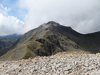
Bidean nam Bian, lying to the south of Glen Coe, Highland, Scotland, is the highest point in the former county of Argyll. It is a complex mountain, with many ridges and subsidiary peaks, one of which, Stob Coire Sgreamhach, is classified as a separate Munro.

Ben Cruachan is a 1126 m mountain that is the highest point in Argyll and Bute, Scotland. It gives its name to the Cruachan Dam, a pumped-storage hydroelectric power station located in a cavern inside the mountain, Cruachan! is the battle cry for Highland clans Campbell and MacIntyre.

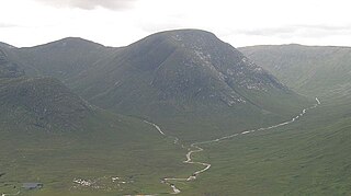
Beinn Ìme is the highest mountain in the Arrochar Alps, in the Southern Highlands of Scotland. There are three usual routes of ascent. From Succoth, one may follow the same path that is used to reach The Cobbler before taking the right fork near the base of the Cobbler's main crags and continuing up the glen, across the bealach and up Ben Ìme's eastern ridge. Alternatively, the summit can be reached from the pass of Rest and be Thankful and from the Loch Lomond side, using the private road that leads to Loch Sloy. Beinn Ìme separates the Dunbartonshire landscape of Loch Lomond in the East and the Argyll Highlands of Loch Fyne and Loch Goil anywhere north, west, south west. Beinn Ìme is the landmark to the entrance to Argyll.
In the geologic timescale, the Roadian is an age or stage of the Permian. It is the earliest or lower of three subdivisions of the Guadalupian Epoch or Series. The Roadian lasted between 273.01 and 266.9 million years ago (Ma). It was preceded by the Kungurian and followed by the Wordian.
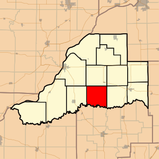
Crane Creek Township is located in Mason County, Illinois. As of the 2010 census, its population was 136 and it contained 73 housing units.
Gunna is an island in the Inner Hebrides of Scotland.
Inchtavannach, is one of the larger islands in Loch Lomond.

Ben Bhuidhe is a Scottish mountain at the head of Loch Fyne, Argyll and Bute.

Meall nan Tarmachan is a mountain in the Southern Highlands of Scotland near Killin just west of Ben Lawers. It is often climbed as part of the Tarmachan ridge, the other peaks of which are Meall Garbh, Beinn nan Eachan and Creag na Caillich ; these three peaks are Tops rather than Munros, and lie to the south-west of Meall nan Tarmachan.

Beinn Chorranach is one of the Arrochar Alps, a mountain range that marks the start of the Argyll Highlands and provides a wilderness of long coastlines and high mountains with forested hill sides. Beinn Chorranach's parent peak is Beinn Ime, the biggest mountain in the range. Beinn Chorranach lies at the head of lower Glen Kinglas and is located between Loch Fyne and Loch Lomond. East of Beinn Chorranach is Loch Lomond as the mountain can be seen from Inversnaid and further east to The Trossachs wilderness. Further west is the rest of the wild Argyll scenery and marks the first real sense of isolation and wilderness after arriving in the Highlands at Loch Lomond.
Cruach nam Mult is a mountain in the Arrochar Alps, Argyll, Scotland which lies to the southern side of Hell's Glen. The mountain is near Loch Fyne and GlenGoil and is part of the northern side of the area of the Arrochar Alps that follow south to Loch Goil.
Argyll's Bowling Green is an area on the Ardgoil estate in Argyll and Bute, Scotland. It is also known as the Ardgoil peninsula and is the most southerly part of the Arrochar Alps and lies between Loch Goil and Loch Long. It is part of the Argyll Forest Park and is within the Loch Lomond and the Trossachs National Park.

Cruach nan Capull is a mountain within the Arrochar Alps, near Loch Fyne, in Argyll and Bute, Scotland. It stands on the southern side of Hell's Glen and rises to a height of 611 m (2005 ft).
Ceabhaigh is a small island in an arm of Loch Ròg on the west coast of Lewis in the Outer Hebrides of Scotland. It is about 25 hectares in extent. It is not known if the island was ever permanently inhabited.

Sgùrr Thuilm is a mountain in the Glenfinnan area of the Highlands of Scotland. It stands at the head of Glen Finnan approximately 7 kilometres (4 mi) north of Loch Shiel.
Edmunds Store is an unincorporated community located in Brunswick County, in the U.S. state of Virginia.
Meall nan Eun is a mountain in the Grampian Mountains of Scotland. It is located east of Glen Etive in Argyll and Bute.
References
Coordinates: 56°9′57″N4°52′36″W / 56.16583°N 4.87667°W
| | This Argyll and Bute location article is a stub. You can help Wikipedia by expanding it. |