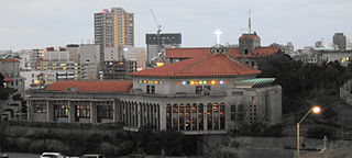
Tomari, Okinawa

Last updated
Tomari Wharf of Naha Port Naha Tomari Port11n4272.jpg
Tomari Wharf of Naha Port

Tomari() is a neighborhood in Naha, Okinawa Prefecture, Japan, where the Tomari Terminal of the port of Naha is located. The terminal is used for ferries and passenger vessels which connect Naha and neighboring islands.

Before the modern city of Naha was established, Tomari was a magiri , a type of municipality. Tomari served as the primary port for Ryukyuan ships travelling within the Ryūkyū Islands to dock and to engage in loading and unloading of their cargo. Tribute received from Amami Ōshima was handled by the local officials at Tomari. [1]

Tribute wealth that one party gives to another as a sign of respect or of submission or allegiance

A tribute (/ˈtrɪbjuːt/) is wealth, often in kind, that a party gives to another as a sign of respect or, as was often the case in historical contexts, of submission or allegiance. Various ancient states exacted tribute from the rulers of land which the state conquered or otherwise threatened to conquer. In case of alliances, lesser parties may pay tribute to more powerful parties as a sign of allegiance and often in order to finance projects that would benefit both parties. To be called "tribute" a recognition by the payer of political submission to the payee is normally required; the large sums, essentially protection money, paid by the later Roman and Byzantine Empires to barbarian peoples to prevent them attacking imperial territory, would not usually be termed "tribute" as the Empire accepted no inferior political position. Payments by a superior political entity to an inferior one, made for various purposes, are described by terms including "subsidy".

Amami Ōshima island in Kagoshima, Japan

Amami Ōshima is one of the Satsunan Islands, and is the largest island within the Amami archipelago between Kyūshū and Okinawa.

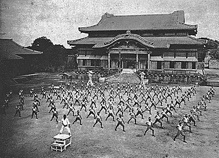
Tomari-te, a style of karate, originated in Tomari. Kyan Chōtoku and Chōki Motobu practiced this style of Okinawan karate.

Karate martial art

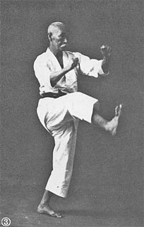
Karate (空手) is a martial art developed in the Ryukyu Kingdom. It developed from the indigenous Ryukyuan martial arts under the influence of Chinese Kung Fu, particularly Fujian White Crane. Karate is now predominantly a striking art using punching, kicking, knee strikes, elbow strikes and open-hand techniques such as knife-hands, spear-hands and palm-heel strikes. Historically, and in some modern styles, grappling, throws, joint locks, restraints and vital-point strikes are also taught. A karate practitioner is called a karateka (空手家).

Related Research Articles

Tokashiki, Okinawa Village in Kyushu, Japan

Tokashiki is a village located in the Kerama Islands in Okinawa Prefecture, Japan. It includes 10 islands, of which only two, Tokashiki and Maejima are inhabited. The village is part of Shimajiri District. Tokashiki is known for its corals, sea, beach and sun. From Tomari Port in Naha, it takes less than one hour to reach this island.

Shorei Ryu is the Naha-Te style of Okinawan karate. Shorei Ryu means "the style of inspiration". It is believed that the term Shorei is derived from the Shoreiji Temple in southern China. The teachings of this temple provided the basis for the Naha-Te style.

Katsuren Castle

Katsuren Castle is a Ryukyuan gusuku in Uruma, Okinawa. It is a UNESCO World Heritage Site.

Okinawa Islands Japanese islands

The Okinawa Islands are an island group in Okinawa Prefecture, Japan, and are the principal island group of the prefecture. The Okinawa Islands are part of the larger Ryukyu Islands group, and are located between the Amami Islands of Kagoshima Prefecture to the northeast and the Sakishima Islands of Okinawa Prefecture to the southwest.

Wanshū is the name of several katas in many systems of karate, including Isshin-Ryu, Shotokan, Wadō-ryū, and others.

United States Civil Administration of the Ryukyu Islands government agency

The United States Civil Administration of the Ryukyu Islands, or "USCAR", was the government in Okinawa, Japan, after World War II from 1950 until 1972.

Chōtoku Kyan Japanese karateka

Chotoku Kyan was an Okinawan karate master who was famous for both his karate skills and his colorful personal life. He had a large influence on the styles of karate that would become Shorin-Ryu and its related styles.

Shikina-en

The gardens of Shikina-en (識名園) are located on a small hill to the south of Shuri Castle in Naha, Okinawa. The residence and its gardens are also known as Shichina-nu-Udun (シチナヌウドゥン) or Southern Gardens (南苑), as opposed to the Eastern Gardens (東苑) or Uchayaudun (御茶屋御殿), laid out on a small hill east of Shuri Castle in 1677. In 1992 Hiroshi Shō, the great-grandson of Shō Tai, the last king of the Ryūkyū Kingdom, donated the royal mausoleum of Tamaudun and Shikina-en to the City of Naha.

Naha Core city in Kyushu, Japan

Naha is the capital city of the Okinawa Prefecture, the southernmost prefecture of Japan.

Shuri, Okinawa city district

Shuri is a district of the city of Naha, Okinawa. It was formerly a separate city in and of itself, and the royal capital of the Ryūkyū Kingdom. A number of famous historical sites are located in Shuri, including Shuri Castle, the Shureimon gate, Sunuhyan-utaki, and royal mausoleum Tamaudun, all of which are designated World Heritage Sites by UNESCO.

Administrative divisions of the Ryukyu Kingdom a type of administrative district of the Ryukyu Kingdom

The administrative divisions of the Ryukyu Kingdom were a hierarchy composed of districts, magiri, cities, villages, and islands established by the Ryukyu Kingdom throughout the Ryukyu Islands.

Okinawan martial arts

Okinawan martial arts refers to the martial arts, such as karate, tegumi and Okinawan kobudō, which originated among the indigenous people of Okinawa Island. Due to its central location, Okinawa was influenced by various cultures with a long history of trade and cultural exchange, including Japan, China and Southeast Asia, that greatly influenced the development of martial arts on Okinawa.

Roman Catholic Diocese of Naha diocese of the Catholic Church

The Roman Catholic Diocese of Naha is a Latin suffragan diocese in the Ecclesiastical province of the Metropolitan Archbishop of Nagasaki 長崎, in southern Japan.

Fukushūen

Fukushūen is a traditional Chinese garden in the Kume area of Naha, Okinawa.

Aguni, Okinawa Village in Kyushu, Japan

Aguni is a village located in Shimajiri District, Okinawa Prefecture, Japan. The village occupies the entirety of Aguni Island.

Ōzato Castle, officially Shimasoe-Ōzato Castle, is a Ryukyuan gusuku built in Nanzan and used until 1429. It, and the village of Ōzato, are named after the Ōzato Dynasty of Nanzan. It is in ruins, and is an officially designated historical site in Nanjō City, Okinawa.

Mie Castle

Mie Castle is a Ryukyuan gusuku in Naha, Okinawa. It is located on the northern mouth of the Kokuba River in Naha Port.

Military of the Ryukyu Kingdom

The military of the Ryukyu Kingdom defended the kingdom from 1429 until 1879. It had roots in the late army of Chūzan, which became the Ryukyu Kingdom under the leadership of King Shō Hashi. The Ryukyuan military operated throughout the Ryukyu Islands, the East China Sea, and elsewhere that Ryukyuan ships went. Ryukyu primarily fought with other Ryukyuan kingdoms and chiefdoms, but also Japanese samurai from Satsuma Domain and pirates. Soldiers were stationed aboard ships and Ryukyuan fortifications. The Ryukyuan military declined after the 17th century.

Flag of Ryukyu

The Flag of Ryukyu is a number of flags that represent the Ryukyu Kingdom, the Ryukyu Islands, and the Ryukyuan people.

References

  1. Uezato, Takashi. "The Formation of the Port City of Naha in Ryukyu and the World of Maritime Asia: From the Perspective of a Japanese Network." Acta Asiatica vol 95 (2008). Tokyo: Tōhō Gakkai (The Institute of Eastern Culture). pp62-63.

Coordinates: 26°13′24″N127°41′13″E / 26.223446°N 127.686968°E / 26.223446; 127.686968

Geographic coordinate system Coordinate system

A geographic coordinate system is a coordinate system that enables every location on Earth to be specified by a set of numbers, letters or symbols. The coordinates are often chosen such that one of the numbers represents a vertical position and two or three of the numbers represent a horizontal position; alternatively, a geographic position may be expressed in a combined three-dimensional Cartesian vector. A common choice of coordinates is latitude, longitude and elevation. To specify a location on a plane requires a map projection.