
Sierra Leone, officially the Republic of Sierra Leone, informally Salone, is a country on the southwest coast of West Africa. It has a tropical climate, with a diverse environment ranging from savanna to rainforests. The country has a total area of 71,740 km2 (27,699 sq mi) and a population of 7,075,641 as of the 2015 census. Sierra Leone is a constitutional republic with a directly elected president and a unicameral legislature. The country's capital and largest city is Freetown. Sierra Leone is made up of five administrative regions: the Northern Province, North West Province, Eastern Province, Southern Province and the Western Area. These regions are subdivided into sixteen districts.
Major Johnny Paul Koroma was the head of state of Sierra Leone from May 1997 to February 1998.

Kabala is the capital and largest town of Koinadugu District in the Northern Province of Sierra Leone. Kabala is one of the main towns in Northern Sierra Leone and is set in a rural landscape, surrounded by mountains.

Koidu Town is the capital and largest city of the diamond-rich Kono District in the Eastern Province of Sierra Leone. The population of Koidu Town is 124,662 based on the 2015 Sierra Leone Census. Koidu Town is the fifth largest city in Sierra Leone by population, after Freetown, Kenema, Bo and Makeni. Koidu Town is a major urban, business, commercial and diamond trade center. Koidu Town lies approximately 270 miles east of Freetown, and about 54 miles north of Kenema.

Nzérékoré, (en-zeer-eh-core) also spelled N'Zérékoré, is the second largest city in Guinea by population, after the capital Conakry and the largest city in the Guinée forestière region of south-eastern Guinea. The city is the capital of the Nzérékoré Prefecture. Nzérékoré is a commercial and economic center and lies approximately 354 miles/569 km southeast of Conakry.

Yengema is a town in Kono District in the Eastern Province of Sierra Leone, lying approximately 14 miles (23 km) south-west Koidu Town, and about 142 miles (229 km) east of Freetown. The major industry in and around Yengema is diamond mining. The town is home to Yengema Airport, the main airport serving Kono District. A 2012 estimate of Yengema population was 13,358 people.

The Sierra Leone Civil War (1991–2002) began on 23 March 1991 when the Revolutionary United Front (RUF), with support from the special forces of Charles Taylor’s National Patriotic Front of Liberia (NPFL), intervened in Sierra Leone in an attempt to overthrow the Joseph Momoh government. The resulting civil war lasted 11 years, enveloped the country, and left over 50,000 dead.

Kailahun is the capital of Kailahun District in the Eastern Province of Sierra Leone. Kailahun is a major business and commercial center of Kailahun District. The population was 13,108 in the 2004 census, a 2006 estimate of 18,411 and a current estimate of about 30,411. Kailahun lies in the far east of Sierra Leone, approximately 200 miles east of Freetown ; and about 51 miles north east of Kenema.
Samuel Sam Bockarie, widely known as Mosquito, was a leading member of the Revolutionary United Front (RUF) in Sierra Leone. Bockarie was infamous during the Sierra Leone Civil War for his brutal tactics, which included amputation, mutilation, and rape. He earned the nickname "Mosquito" for his ability to attack when his enemies were off-guard mainly during the night. During his service in the RUF, he befriended future Liberian president Charles Taylor, and RUF commander Foday Sankoh. When Sankoh was imprisoned from March 1997 until April 1999, Bockarie served as commander of the RUF in his place.
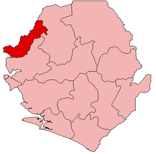
Kambia District is a district in the Northern Province of Sierra Leone. Its capital and largest city is the town of Kambia. As of the 2015 census, The District had a population of 343,686. Kambia District borders the Republic of Guinea to the north, Port Loko District to the south and Bombali District to the east. The district provides an important Trade route to or from the Sierra Leonean capital Freetown to the Guinean capital Conakry.
Articles related to Sierra Leone include:
Waterloo is a city in the Western Area of Sierra Leone and the capital of the Western Area Rural District, which is one of the sixteen districts of Sierra Leone. Waterloo is located about twenty miles east of Freetown. Waterloo is the second largest city in the Western Area region of Sierra Leone, after Freetown.. The city had a population of 34,079 in the 2004 census and a 2013 estimate of 40,000. Waterloo is part of Freetown metropolitan area.
Segbwema is a town in Kailahun District in the Eastern Province of Sierra Leone. The town is a major business and agricultural centre. Segbwema lies approximately 20 miles northeast of Kenema and about 225 miles south-east of Freetown. The population of Segbwema was 7,961 in the 2004 census with a current estimate of 16,532.
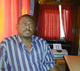
Alex Tamba Brima, also known as Gullit, was a Sierra Leonean military commander. He was one of a group of seventeen soldiers in the Sierra Leone Armed Forces who called themselves Armed Forces Revolutionary Council (AFRC) that successfully staged a coup that ousted president Ahmad Tejan Kabbah in May 1997. On 19 July 2007 he was convicted and sentenced to 50 years in prison for committing war crimes and crimes against humanity during the Sierra Leone Civil War.

Guéckédou or Guékédou is a town in southern Guinea near the Sierra Leone and Liberian borders. It had a population of 79,140 in 1996 (census) but has grown massively since the civil wars and, as of 2008, it is estimated to be 221,715. It was a centre of fighting during the Second Liberian Civil War and the Sierra Leone Civil War in 2000 and 2001.
Water supply in Sierra Leone is characterized by limited access to safe drinking water. Despite efforts by the government and numerous non-governmental organizations, access has not much improved since the end of the Sierra Leone Civil War in 2002, stagnating at about 50% and even declining in rural areas. In the capital Freetown, taps often run dry. It is hoped that a new dam in Orugu, for which China committed financing in 2009, will alleviate water scarcity.
Jawei Chiefdom is a chiefdom in Kailahun District of Sierra Leone with a population of 42,635. Its largest town and headquarters is Daru.
Kamara Chiefdom is a chiefdom in Kono District of Sierra Leone. Its capital is Tombodu.


