
Located on the northwestern coast of the U.S. state of Washington, Puget Sound is a complex estuarine system of interconnected marine waterways and basins. As a part of the Salish Sea the sound has one major and two minor connections to the Strait of Juan de Fuca, which in turn connects to the open Pacific Ocean. The major connection is Admiralty Inlet; the minor connections are Deception Pass and the Swinomish Channel.
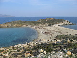
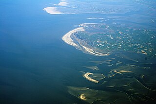
A tombolo is a sandy or shingle isthmus. A tombolo, from the Italian tombolo, meaning 'pillow' or 'cushion', and sometimes translated incorrectly as ayre, is a deposition landform by which an island becomes attached to the mainland by a narrow piece of land such as a spit or bar. Once attached, the island is then known as a tied island.

Chesil Beach in Dorset, England is one of three major shingle beach structures in Britain. Its name is derived from the word chessil, meaning "gravel" or "shingle". It runs for a length of 29 kilometres (18 mi) from West Bay to the Isle of Portland and in places is up to 15 metres (50 ft) high and 200 metres (660 ft) wide. Behind the beach is the Fleet, a shallow tidal lagoon. Both are part of the Jurassic Coast and a UNESCO World Heritage Site, and together form an SSSI and Ramsar Site. Owners of the land designated as Chesil & The Fleet SSSI include the Crown Estate, the Ministry of Defence and the National Trust.

In oceanography, geomorphology, and geoscience, a shoal is a natural submerged ridge, bank, or bar that consists of, or is covered by, sand or other unconsolidated material, and rises from the bed of a body of water close to the surface or above it, which poses a danger to navigation. Shoals are also known as sandbanks, sandbars, or gravelbars. Two or more shoals that are either separated by shared troughs or interconnected by past or present sedimentary and hydrographic processes are referred to as a shoal complex.

A spit or sandspit is a deposition bar or beach landform off coasts or lake shores. It develops in places where re-entrance occurs, such as at a cove's headlands, by the process of longshore drift by longshore currents. The drift occurs due to waves meeting the beach at an oblique angle, moving sediment down the beach in a zigzag pattern. This is complemented by longshore currents, which further transport sediment through the water alongside the beach. These currents are caused by the same waves that cause the drift.

The northern elephant seal is one of two species of elephant seal. It is a member of the family Phocidae. Elephant seals derive their name from their great size and from the male's large proboscis, which is used in making extraordinarily loud roaring noises, especially during the mating competition. Sexual dimorphism in size is great. Correspondingly, the mating system is highly polygynous; a successful male is able to impregnate up to 50 females in one season.

Nishiizu is a town located in Kamo District, Shizuoka Prefecture, Japan. As of 1 August 2019, the town had an estimated population of 7,798 in 3764 households, and a population density of 74 persons per km². The total area of the town was 105.52 square kilometres (40.74 sq mi).
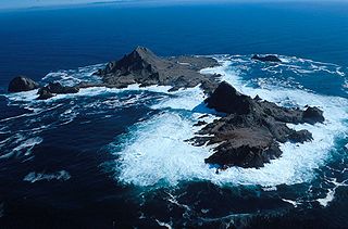
The Farallon IslandsFA-ra-lon, or Farallones, are a group of islands and sea stacks in the Gulf of the Farallones, off the coast of San Francisco, California, United States. The islands are also sometimes referred to by mariners as the Devil's Teeth Islands, in reference to the many treacherous underwater shoals in their vicinity. The islands lie 30 miles (48 km) outside the Golden Gate and 20 miles (32 km) south of Point Reyes, and are visible from the mainland on clear days. The islands are part of the City and County of San Francisco. The only inhabited portion of the islands is on Southeast Farallon Island (SEFI), where researchers from Point Blue Conservation Science and the U.S. Fish and Wildlife Service stay. The islands are closed to the public.
Huney is an uninhabited island due east of the island of Unst in the Shetland Islands, Scotland. The island is located approximately 1 kilometre south west of Balta and has an area of just under 0.2 square kilometres (0.08 sq mi). Huney is separated from Unst by a narrow channel called The Yei. At extremely low tides a sandy tombolo may connect Huney to Unst.

St Ninian's Isle is a small tied island connected by the largest tombolo in the UK to the south-western coast of the Mainland, Shetland, in Scotland. It is part of the civil parish of Dunrossness on the South Mainland. The tombolo, known locally as an ayre from the Old Norse for "gravel bank", is 500 metres long. During the summer the tombolo is above sea level and accessible to walkers. During winter, stronger wave action removes sand from the beach so that it is usually covered at high tide, and occasionally throughout the tidal cycle, until the sand is returned the following spring. Depending on the definition used, St. Ninian's is thus either an island, or a peninsula; it has an area of about 72 hectares.

Charles Island is a 14-acre island located roughly 0.5 mile (1 km) off the coast of Milford, Connecticut, in Long Island Sound centered at 41°11′28.32″N73°03′18″W.

Ma Shi Chau (Chinese: 馬屎洲; Sidney Lau: Ma5Si2Jau1, literally "Horse Dung Island") is an island of Hong Kong, under the administration of Tai Po District. It is located in Tolo Harbour in the northeast New Territories (near Sam Mun Tsai). It is connected with another island, Yim Tin Tsai, by a tombolo traversable at low tide.

Sharp Island or Kiu Tsui Chau is the largest island in the Kiu Tsui Country Park located at Port Shelter of Sai Kung, Hong Kong. The area is most known for fishing, swimming as well as diving. Sharp Island is under the administration of Sai Kung District.

Cana Island is an island in Lake Michigan in the town of Baileys Harbor in Door County, Wisconsin, United States. The Cana Island Light is on the east side of the island. It is possible to walk to Cana Island from the mainland over the tombolo when water levels are low. Tombolo conditions are monitored by a webcam operated by the county parks department. The island is part of the Town of Baileys Harbor, Wisconsin.
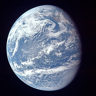
The ocean is the body of salt water that covers approximately 70.8% of Earth. In English, the term ocean also refers to any of the large bodies of water into which the world ocean is conventionally divided. The following names describe five different areas of the ocean: Pacific, Atlantic, Indian, Antarctic/Southern, and Arctic. The ocean contains 97% of Earth's water and is the primary component of Earth's hydrosphere; thus the ocean is essential to life on Earth. The ocean influences climate and weather patterns, the carbon cycle, and the water cycle by acting as a huge heat reservoir.
The coastline of the North Sea has been evolving since the end of the last ice age. The coastline varies from fjords, river estuaries to mudflats.

The Sugar Loaf Islands are a collection of five small uninhabited islands and several sea stacks near Port Taranaki, New Zealand.
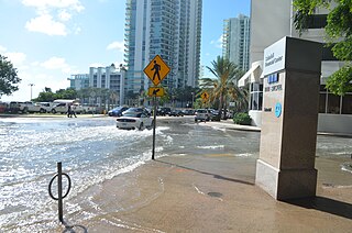
Tidal flooding, also known as sunny day flooding or nuisance flooding, is the temporary inundation of low-lying areas, especially streets, during exceptionally high tide events, such as at full and new moons. The highest tides of the year may be known as the king tide, with the month varying by location. These kinds of floods tend not to be a high risk to property or human safety, but further stress coastal infrastructure in low lying areas.

Dogashima is a scenic coastal area in Nishiizu, Japan. It is also known as "Izu's Matsushima" due to the beauty of its scenery which features pumice cliffs, volcanic rock formations, sea caves, and uninhabited islands.


