This article needs additional citations for verification .(November 2023) |
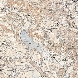
The Topographic Atlas of Switzerland (German: Topographischer Atlas der Schweiz), also known as the Siegfried Atlas or Siegfried Map (German: Siegfriedkarte; French: Carte Siegfried), is an official map series of Switzerland. Its publication was begun by the Federal Topographic Bureau under Hermann Siegfried , and continued from 1870 to 1926. [1] During this period the individual maps were drawn by different lithographers, including Walter Hauenstein, Georg Christian von Hoven and Rudolf Leuzinger. Since it is, in today's parlance, not strictly an atlas but a map series, map historians now describe it only by the expression Siegfried Map.
The Siegfried Map was based on the original records that had already been created for the earlier Dufour Map. However, the Siegfried Map offered greater precision than the Dufour Map, by using a scale of 1:25,000 for the Swiss Plateau, the French Prealps, the Jura Mountains and southern Ticino, and a scale of 1:50,000 for other mountain regions and the Swiss Alps.
The area covered by the former scale was initially divided into 462 pages, and the other area into 142 pages, with the two areas overlapping in places. A format of 35 centimetres (14 in) x 24 centimetres (9.4 in) for each page was common to both scales.
Another significant departure from the Dufour Map was the presence of contours to symbolize the relief (a granularity of 10 metres (33 ft) for the 1:25 000 pages, and 30 metres (98 ft) for the 1:50 000 pages). In addition, three colors were used directly for printing, whereas the Dufour Map was initially monochrome. On the Siegfried Map, the colours used were brown for the contour lines on vegetated terrain, blue for water and contour lines on glaciers, and black for the rest.
The Siegfried Map projection was a cone equivalent, as for the Dufour Map.
The print mode used for the 1:25,000 pages was initially intaglio, and from 1905 a printing plate. The 1:50,000 pages were printed via a lithography process, and from 1910 by intaglio.
Until 1949, there were occasional revised editions of Siegfried Map pages. From 1952, the Siegfried and Dufour Maps were replaced by the new National Map of Switzerland.
In modern mapping, a topographic map or topographic sheet is a type of map characterized by large-scale detail and quantitative representation of relief features, usually using contour lines, but historically using a variety of methods. Traditional definitions require a topographic map to show both natural and artificial features. A topographic survey is typically based upon a systematic observation and published as a map series, made up of two or more map sheets that combine to form the whole map. A topographic map series uses a common specification that includes the range of cartographic symbols employed, as well as a standard geodetic framework that defines the map projection, coordinate system, ellipsoid and geodetic datum. Official topographic maps also adopt a national grid referencing system.
The National Topographic System or NTS is the system used by Natural Resources Canada for providing general purpose topographic maps of the country. NTS maps are available in a variety of scales, the standard being 1:50,000 and 1:250,000 scales. The maps provide details on landforms and terrain, lakes and rivers, forested areas, administrative zones, populated areas, roads and railways, as well as other human-made features. These maps are currently used by all levels of government and industry for forest fire and flood control, depiction of crop areas, right-of-way, real estate planning, development of natural resources and highway planning. To add context, land area outside Canada is depicted on the 1:250,000 maps, but not on the 1:50,000 maps.
A geologic map or geological map is a special-purpose map made to show various geological features. Rock units or geologic strata are shown by color or symbols. Bedding planes and structural features such as faults, folds, are shown with strike and dip or trend and plunge symbols which give three-dimensional orientations features.
Swisstopo is the official name for the Swiss Federal Office of Topography, Switzerland's national mapping agency.
The World Atlas is the Soviet and later Russian created and produced atlas of the world.
Norge 1:50 000 is the main series of 727 topographical maps in 1:50,000 scale that cover the entire mainland area of Norway and proximate islands. The civilian designation is Norway 1:50 000 and the military designation is M711.
The cartography of Switzerland is the history of surveying and creation of maps of Switzerland. Switzerland has had its current boundaries since 1815, but maps of the Old Swiss Confederacy were drawn since the 16th century. The first topographical survey on a federal level began in 1809, resulting in the Topographic Map of Switzerland or Dufour Map. From 1869 to 1901, this map was replaced by the Topographic Atlas of Switzerland or Siegfried Map.
The National Maps of Switzerland, also referred to as the Swisstopo maps, are a set of official map series designed, edited and distributed by Swisstopo, the Swiss Federal Office of Topography. Each map series is based on an oblique, conformal, cylindrical projection, with a Swiss Coordinate system. All maps are updated in a complete cycle of about six years.
The Dunantspitze, formerly called Ostspitze, is a peak of the Monte Rosa Massif in the Pennine Alps in Switzerland. It is the second highest peak of the massif, after the Dufourspitze (4,634 m) and the second highest summit in Switzerland, but its prominence is only about 15 metres. At the time of its first ascent it was unclear which of the summits was the higher.
Hachures are an older mode of representing relief. They show orientation of slope, and by their thickness and overall density they provide a general sense of steepness. Being non-numeric, they are less useful to a scientific survey than contours, but can successfully communicate quite specific shapes of terrain. They are a form of shading, although different from the one used in shaded maps.
An orienteering map is a map specially prepared for use in orienteering events. It is a large-scale topographic map with extra markings to help the participant navigate through the course.
A national mapping agency (NMA) is an organisation, usually publicly owned, that produces topographic maps and geographic information of a country. Some national mapping agencies also deal with cadastral matters.
A map series is a group of topographic or thematic charts or maps usually having the same scale and cartographic specifications, and with each sheet appropriately identified by its publisher as belonging to the same series.
The Topographic Map of Switzerland, also known as the Dufour Map is a 1:100 000 scale map series depicting Switzerland for the first time based on accurate geometric measurements. It is also the oldest official map series of Switzerland.
Rudolf Leuzinger was a Swiss cartographer. He is known as one of the most prolific cartographers in Switzerland and one of the best interpreters of mountain landscapes and geologic forms. Leuzinger was also the first to produce terrain maps in color lithography. His more than 300 maps are a rare combination of accuracy, scientific thoroughness and artistry and earned him several national and international honors.
Charles Jacot-Guillarmod was a Swiss topographer and geographer. He was born in La Chaux-de-Fonds in 1868 and he died in Noiraigue in 1925.