
Gairloch is a village, civil parish and community on the shores of Loch Gairloch in Wester Ross, in the North-West Highlands of Scotland. A tourist destination in the summer months, Gairloch has a golf course, a museum, several hotels, a variety of shops, takeaway restaurants, a community centre, a leisure centre with sports facilities, a local radio station, beaches and nearby mountains. Gairloch is one of the principal villages on the North Coast 500 route.

Motherwell is a town and former burgh in North Lanarkshire, Scotland, United Kingdom, south east of Glasgow. It has a population of around 32,120. Historically in the parish of Dalziel and part of Lanarkshire, Motherwell is the headquarters for North Lanarkshire Council. Geographically the River Clyde separates Motherwell from Hamilton to the west whereas the South Calder Water separates Motherwell from Carfin to the north-east and New Stevenston and Bellshill towards the north.

Wishaw is a large town in North Lanarkshire, Scotland, on the edge of the Clyde Valley, 15 miles (24 km) south-east of Glasgow city centre. The Burgh of Wishaw was formed in 1855 within Lanarkshire. It formed a joint large burgh with its neighbour Motherwell from 1920 until its dissolution when Scottish local authorities were restructured in 1975, and was then in Motherwell district within the Strathclyde region until 1996. The town is part of the Motherwell and Wishaw constituency. It has the postal code of ML2 and the dialling code 01698.

Netherlee is a suburban residential area in East Renfrewshire, Scotland. It is situated on the west bank of the White Cart Water about 4 miles (6.5 km) south of Glasgow city centre. Part of the Greater Glasgow conurbation, it is mostly contiguous with the city, and is just beyond the boundary of its local authority area. It is a separate census locality from Glasgow, like other areas such as neighbouring Giffnock and Clarkston. Netherlee is directly contiguous with Stamperland. It is also in a council ward with Clarkston and its neighbour Busby. As of 2012, Netherlee has a population of 4,550.

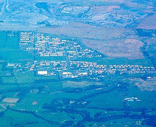
Cleland is a village near Motherwell and Wishaw in North Lanarkshire, Scotland,. As of 2018, it has a population of about 3,000. The village has a strong coal mining heritage, and is a typical example of a working class village in North Lanarkshire and the Glasgow area. Due to its location, despite being at the heart of North Lanarkshire, the village is isolated, geographically and culturally, from surrounding towns such as Motherwell, Shotts and Wishaw.

Uddingston is a small town in South Lanarkshire, Scotland. It is on the north side of the River Clyde, south-east of Glasgow city centre, and acts as a dormitory suburb for the city.

Stamperland is a suburban neighbourhood in Clarkston, East Renfrewshire, Scotland. Part of the Greater Glasgow conurbation, it is situated on the west bank of the White Cart Water about 4.5 miles (7.2 km) south of Glasgow city centre, and just outside the city boundary.

Catrine is a village in East Ayrshire, Scotland which was formerly a centre of cotton manufacture. It has a population of around 2,020 (mid-2020 est.)

Shotts is a small town in North Lanarkshire, Scotland. It is located almost halfway between Glasgow and Edinburgh. The town has a population of about 8,840. A local story has Shotts being named after the legendary giant highwayman Bertram de Shotts, though toponymists give the Anglo-Saxon scēots as the real source of the name. Shotts is the home of the world famous Shotts and Dykehead Caledonia Pipe Band, 16 time winners of World Pipe Band Championships.

Newarthill is a village in North Lanarkshire, Scotland, situated roughly three miles north-east of the town of Motherwell. It has a population of around 6,200. Most local amenities are shared with the adjacent villages of Carfin, Holytown and New Stevenston which have a combined population of around 20,000 across the four localities.
Forth is a village in South Lanarkshire, Scotland with a population of around 3,500 people. It is situated near Lanark, and stands at around 950 feet above sea level. It is on the A706 road between Lanark and Whitburn.
Plains is a village outside the town of Airdrie, in North Lanarkshire, Scotland, about 14 miles (23 km) east of Glasgow city centre and 32 miles (51 km) west of Edinburgh. The nearest major towns are Airdrie and Coatbridge. The village is west of Caldercruix and the North Calder Water. The population is about 2,740.
Stoneyburn is a village in West Lothian, Scotland. Nearby towns include Bathgate, Whitburn, Addiewell and Blackburn.

Hopeman is a seaside village in Moray, Scotland, it is situated on the coast of the Moray Firth, founded in 1805 to house and re-employ people displaced during the Highland clearances. According to the 2011 census, Hopeman has a population of 1,724 and approximately 701 households.
Blue Bus of North Lanarkshire, also known as Blue Bus of Shotts or Law of Shotts, is a bus operator primarily serving the area of Shotts, North Lanarkshire in West Scotland.

Kingswells is a village and suburb of Aberdeen, Scotland, situated west of the city and to the east of Westhill.

East Calder is a village located in West Lothian, Scotland, about a mile east of Mid Calder and a mile west of Wilkieston. It forms part of 'the Calders, three small neighbouring communities situated west of Edinburgh and south of the "New Town" of Livingston.
Caldercruix is a semi-rural village in North Lanarkshire, Scotland. The nearest major town is Airdrie, 4 miles to the west. It has a population of about 2,440. The village is about 20 miles east of Glasgow and 32 miles west of Edinburgh.

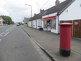
Newmains is a village and former mining community on the eastern edge of Wishaw, North Lanarkshire, Scotland, 18 miles (29 km) south-east of Glasgow. Although it is considered by the local authority to have a town centre in its own right.
Chapelhall is a village outside the town of Airdrie in North Lanarkshire, Scotland. With house building, the distinction between Airdrie and Chapelhall is being eroded. Established as a small mining village in the 19th century, it now has population of around 6,560. Chapelhall is situated just off the M8 motorway 13 miles (21 km) east of Glasgow city centre and around 33 miles (53 km) west of Edinburgh. Chapelhall is also near to many of Lanarkshire's main towns, such as Bellshill, Coatbridge, Motherwell, Hamilton and Cumbernauld, as well as being around 3 miles (4.8 km) away from Airdrie town centre. The Eurocentral freight village/industrial estate is just a mile or so away and employs people from around Lanarkshire, Glasgow and West Lothian. The rail-freight village links with Grangemouth docks 28 miles (45 km) away,.