
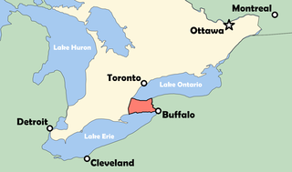
Lake Ontario is one of the five Great Lakes of North America. It is bounded on the north, west, and southwest by the Canadian province of Ontario, and on the south and east by the U.S. state of New York. The Canada–United States border spans the centre of the lake.

The Province of Upper Canada was a part of British Canada established in 1791 by the Kingdom of Great Britain, to govern the central third of the lands in British North America, formerly part of the Province of Quebec since 1763. Upper Canada included all of modern-day Southern Ontario and all those areas of Northern Ontario in the Pays d'en Haut which had formed part of New France, essentially the watersheds of the Ottawa River or Lakes Huron and Superior, excluding any lands within the watershed of Hudson Bay. The "upper" prefix in the name reflects its geographic position along the Great Lakes, mostly above the headwaters of the Saint Lawrence River, contrasted with Lower Canada to the northeast.
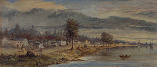
York was a town and the second capital of the colony of Upper Canada. It is the predecessor to the old city of Toronto (1834–1998). It was established in 1793 by Lieutenant-Governor John Graves Simcoe as a "temporary" location for the capital of Upper Canada, while he made plans to build a capital near today's London, Ontario. Simcoe renamed the location York after Prince Frederick, Duke of York and Albany, George III's second son. Simcoe gave up his plan to build a capital at London, and York became the permanent capital of Upper Canada on February 1, 1796. That year Simcoe returned to Britain and was temporarily replaced by Peter Russell.

The Regional Municipality of York, also called York Region, is a regional municipality in Southern Ontario, Canada, between Lake Simcoe and Toronto. The region was established after the passing of then Bill 102, An Act to Establish The Regional Municipality of York, in 1970. It replaced the former York County in 1971, and is part of the Greater Toronto Area and the inner ring of the Golden Horseshoe. The regional government is headquartered in Newmarket.

The Greater Toronto Area, commonly referred to as the GTA, includes the City of Toronto and the regional municipalities of Durham, Halton, Peel, and York. In total, the region contains 25 urban, suburban, and rural municipalities. The Greater Toronto Area begins in Burlington in Halton Region to the west, and extends along Lake Ontario past downtown Toronto eastward to Clarington in Durham Region.

Yonge Street is a major arterial route in the Canadian province of Ontario connecting the shores of Lake Ontario in Toronto to Lake Simcoe, a gateway to the Upper Great Lakes. Ontario's first colonial administrator, John Graves Simcoe, named the street for his friend Sir George Yonge, an expert on ancient Roman roads.

The Frederick G. Gardiner Expressway, commonly known as the Gardiner Expressway or simply the Gardiner, is a partially at grade and elevated municipal expressway in Toronto, Ontario, Canada. Running close to the shore of Lake Ontario, it extends from the foot of the Don Valley Parkway (DVP) in the east, just past the mouth of the Don River, to the junction of Highway 427 and the Queen Elizabeth Way (QEW) in the west, for a total length of 18.0 kilometres (11.2 mi). East of Dufferin Street to just east of the Don River, the roadway is elevated for a length of 6.8 kilometres (4.2 mi), unofficially making it the longest bridge in Ontario.
The Niagara Peninsula is an area of land lying between the southwestern shore of Lake Ontario and the northeastern shore of Lake Erie, in Ontario, Canada. Technically an isthmus rather than a peninsula, it stretches from the Niagara River in the east to Hamilton, Ontario, in the west. The peninsula is located in the Golden Horseshoe region of Southern Ontario, and has a population of roughly 1,000,000 residents. The region directly across the Niagara River and Lake Erie in New York State is known as the Niagara Frontier.

New Toronto is a neighbourhood and former municipality in Toronto, Ontario, Canada. It is located in the south-west area of Toronto, along Lake Ontario. The Town of New Toronto was established in 1890, and was designed and planned as an industrial centre by a group of industrialists from Toronto who had visited Rochester, New York. New Toronto was originally a part of the Township of Etobicoke. It was an independent municipality from 1913 to 1967, being one of the former 'Lakeshore Municipalities' amalgamated into the Borough of Etobicoke, and eventually amalgamated into Toronto. The neighbourhood has retained the name.

Glacial Lake Iroquois was a prehistoric proglacial lake that existed at the end of the last ice age approximately 13,000 years ago.
Mimico is a neighbourhood in Toronto, Ontario, Canada, being located in the south-west area of Toronto on Lake Ontario. It is in the south-east corner of the former Township of Etobicoke, and was an independent municipality from 1911 to 1967.

Toronto Harbour or Toronto Bay is a natural bay on the north shore of Lake Ontario, in Toronto, Ontario, Canada. Today, the harbour is used primarily for recreational boating, including personal vessels and pleasure boats providing scenic or party cruises. Ferries travel from docks on the mainland to the Islands, and cargo ships deliver aggregates and raw sugar to industries located in the harbour. Historically, the harbour has been used for military vessels, passenger traffic and cargo traffic. Waterfront uses include residential, recreational, cultural, commercial and industrial sites.
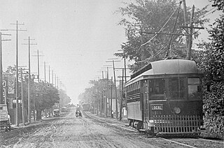
The Metropolitan line in the Toronto area, operated by the Metropolitan Street Railway, started out as a local horsecar line and transformed itself into an electric radial line extending to Lake Simcoe, following an old stage coach route. In 1904, the railway was acquired by the Toronto and York Radial Railway (T&YRR) and became the T&YRR Metropolitan Division. In 1922, the City of Toronto acquired the T&YRR and contracted Ontario Hydro to manage the four T&YRR lines including the Metropolitan. In 1927, the TTC took over the operation of the Metropolitan Line to Sutton, and renamed it the Lake Simcoe line. In 1930, the TTC closed the Metropolitan Line but shortly reopened the portion between Glen Echo and Richmond Hill operating it as the North Yonge Railways until 1948.

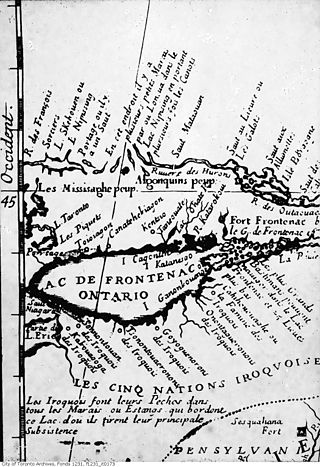
Toronto was founded as the Town of York and capital of Upper Canada in 1793 after the Mississaugas sold the land to the British in the Toronto Purchase. For over 12,000 years, Indigenous People have lived in the Toronto area. The ancestors of the Huron-Wendat were the first known groups to establish agricultural villages in the area about 1,600 years ago.
The name of Toronto has a history distinct from that of the city itself. Originally, the term "Tkaronto" referred to a channel of water between Lake Simcoe and Lake Couchiching on maps as early as 1675 but in time the name passed southward, and was eventually applied to a new fort at the mouth of the Humber River. Fort Toronto was the first European settlement in the area, and lent its name to what became the city of Toronto.
The Toronto Purchase was the sale of lands in the Toronto area from the Mississaugas of New Credit to the British crown. An initial, disputed, agreement was made in 1787, in exchange for various items. The agreement was revisited in 1805, intended to clarify the area purchased. The agreement remained in dispute for over 200 years until 2010, when a settlement for the land was made between the Government of Canada and the Mississaugas for the land and other lands in the area.

The Queensway–Humber Bay, known officially as Stonegate–Queensway, is a neighbourhood in the southwest of Toronto, Ontario, Canada. It is located in the southeast area of the former City of Etobicoke.
Yonge Street is a major arterial route in the Canadian province of Ontario connecting the shores of Lake Ontario in Toronto to Lake Simcoe, a gateway to the Upper Great Lakes. Ontario's first colonial administrator, John Graves Simcoe, named the street for his friend Sir George Yonge, an expert on ancient Roman roads.
Bead Hill is an archaeological site comprising the only known remaining and intact 17th-century Seneca site in Canada. It is located on the banks of the Rouge River in Rouge Park, a national park in Toronto, Ontario. Because of its sensitive archaeological nature, it is not open to the public, nor readily identified in the park. It was designated a National Historic Site in 1991, eventually becoming a unit of the national park system in June 2019.

