
Torvaianica or Torvajanica is a frazione of the comune of Pomezia, in the Metropolitan City of Rome, central Italy. Counting some 12,700 inhabitants, it extends for some eight kilometres (5.0 miles) on central Lazio's littoral.
Torvaianica or Torvajanica is a frazione of the comune of Pomezia, in the Metropolitan City of Rome, central Italy. Counting some 12,700 inhabitants, it extends for some eight kilometres (5.0 miles) on central Lazio's littoral.

According to Vergil's Aeneid , the Trojan hero Aeneas landed here: this event is confirmed by the excavation of the ancient Roman town of Lavinium in the neighbourhood of Torvaianica.
The name derives from a coastal watch tower, Torre del Vajanico, built in 1580 to defend against Barbary pirates attacks. The tower was damaged during World War II and demolished during the 1960s building speculations. The town was founded in the 1940s, after the reclamation of the Pontine Marshes; population at the time was mostly composed of fishermen.
The economy is mostly based on tourism. Torvaianica is home to the Zoomarine amusement park.
A Roman villa has been excavated nearby.
41°37′14″N12°27′46″E / 41.62056°N 12.46278°E
| Authority control: National |
|---|

Kiowa is a home rule municipality town and the county seat of Elbert County, Colorado, United States. The town population was 725 at the 2020 United States Census.

Spoleto is an ancient city in the Italian province of Perugia in east-central Umbria on a foothill of the Apennines. It is 20 km (12 mi) S. of Trevi, 29 km (18 mi) N. of Terni, 63 km (39 mi) SE of Perugia; 212 km (132 mi) SE of Florence; and 126 km (78 mi) N of Rome.

Rumelia, etymologically "Land of the Romans", at the time meaning Eastern Orthodox Christians and more specifically Christians from the Byzantine rite, was the name of a historical region in Southeastern Europe that was administered by the Ottoman Empire, corresponding to the Balkans. In its wider sense, it was used to refer to all Ottoman possessions and vassals in Europe that would later be geopolitically classified as "the Balkans". During the period of its existence, it was more often known in English as Turkey in Europe.
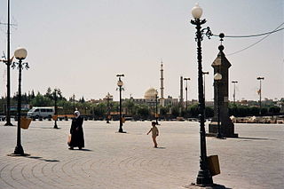
Bosra, also spelled Bostra, Busrana, Bozrah, Bozra and officially called Busra al-Sham, is a town in southern Syria, administratively belonging to the Daraa District of the Daraa Governorate and geographically part of the Hauran region.

Travnik is a town and a municipality in Bosnia and Herzegovina. It is the administrative center of Central Bosnia Canton of the Federation of Bosnia and Herzegovina. It is situated in central Bosnia and Herzegovina, 90 kilometres west of Sarajevo. As of 2013, the town had a population of 15,344 inhabitants, while the municipality had 53,482 inhabitants.

Tigranocerta, also called Cholimma or Chlomaron in antiquity, was a city and the capital of the Armenian Kingdom between 77 and 69 BCE. It bore the name of Tigranes the Great, who founded the city in the first century BC. There is so far no common agreement on the precise location of Tigranakert; it was either near present-day Silvan, Arzan, east of Diyarbakır, Turkey, or in the valley of the Garzan river mentioned by T. A. Sinclair. It was one of four cities in historic Armenia named Tigranakert. The others were in Nakhichevan, Artsakh and Utik, the 4 cities being in the old Armenian provinces Aldznik, Goghtn, Utik, Artsakh.

The Province of L'Aquila is the largest, most mountainous and least densely populated province of the Abruzzo region of Central Italy. It comprises about half the landmass of Abruzzo and occupies the western part of the region. It has borders with the provinces of Teramo to the north, Pescara and Chieti to the east, Isernia to the south and Frosinone, Rome and Rieti to the west. Its capital is the city of L'Aquila.
IEC 62056 is a set of standards for electricity metering data exchange by International Electrotechnical Commission.

Mediana is an important archeological site from the late Roman period, located in the eastern suburb of the Serbian city of Niš. It represents a luxurious residence with a highly organised economy. Excavations have revealed a villa with peristyle, thermae, granary and water tower. The residence dates to the reign of Constantine the Great 306 to 337. Although Roman artifacts can be found scattered all over the area of present-day Niš, Mediana represents the best-preserved part of Roman Naissus. In 1979, Mediana was added to the Archaeological Sites of Exceptional Importance list, protected by the Republic of Serbia.

Norba, an ancient town of Latium (Adjectum), Italy. It is situated 1 mile northwest of the modern town of Norma, on the western edge of the Volscian Mountains or Monti Lepini. The town is perched above a precipitous cliff with a splendid view over the Pomptine Marshes below; the highest point stands to ca. 460 meters above sea level.
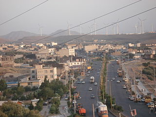
Manjil is a city in the Central District of Rudbar County, Gilan Province, Iran. At the 2006 census, its population was 16,028, in 4,447 families.

Kiskőrös is a town in Bács-Kiskun, Hungary. Kiskőrös is situated between the Danube and Tisza rivers at around 46°37′14″N19°17′19″E. Sándor Petőfi, the national poet of Hungary, was born here.
Ceri is a hamlet (frazione) of the comune of Cerveteri, in the Metropolitan City of Rome, Lazio. It occupies a fortified plateau of tuff at a short distance from the city of Cerveteri.

Central Station is a residential development project in the South Loop section of Chicago, Illinois. Originally planned as a 69 acres (28 ha) development, it was later expanded to 72 acres (29 ha), and is now 80 acres (32 ha). Being planned by the city government, it encompasses the former rail yards and air space rights east of Michigan Avenue between Roosevelt Road and 18th Street.
Okarpiec is a settlement in the administrative district of Gmina Osiek, within Starogard County, Pomeranian Voivodeship, in northern Poland. It lies approximately 4 kilometres (2 mi) south-west of Osiek, 31 km (19 mi) south of Starogard Gdański, and 76 km (47 mi) south of the regional capital Gdańsk.
Jelonek is a village in the administrative district of Gmina Borne Sulinowo, within Szczecinek County, West Pomeranian Voivodeship, in north-western Poland. It lies approximately 8 kilometres (5 mi) north-east of Borne Sulinowo, 12 km (7 mi) south-west of Szczecinek, and 137 km (85 mi) east of the regional capital Szczecin.
Long Sơn Island is an estuary island near Vũng Tàu, Vietnam.

Santa Maria della Piazza is a church in Ancona, central Italy.

Santa Sofia is a Roman Catholic church in the town of Benevento, in the region of Campania, in southern Italy; founded in the late-8th century, it retains many elements of its original Lombard architecture.
McDuff is a ghost town in Bastrop County, Texas, United States. The community was located 8 miles southwest of Elgin, 12 miles northwest of Bastrop, and 25 miles east of Austin. It was on an old stage mail route from Bastrop to Austin. Today, the town site would correspond roughly with the intersection of Farm to Market Road 969 and Upper Elgin River Road.