Related Research Articles

Darwin is the capital city of the Northern Territory, Australia. With a 2018 estimated population of 148,564, it has more residents than the rest of the sparsely populated Northern Territory. It is the smallest, wettest, and most northerly of the Australian capital cities and serves as the Top End's regional centre.

The Northern Territory is an Australian territory in the central and central northern regions of Australia. It shares borders with Western Australia to the west, South Australia to the south, and Queensland to the east. To the north, the territory looks out to the Timor Sea, the Arafura Sea and the Gulf of Carpentaria, including Western New Guinea and other islands of the Indonesian archipelago.
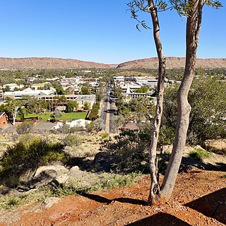
Alice Springs is the third-largest town in the Northern Territory of Australia. Known as Stuart until 31 August 1933, the name Alice Springs was given by surveyor William Whitfield Mills after Alice, Lady Todd, wife of the telegraph pioneer Sir Charles Todd. Now colloquially known as The Alice or simply Alice, the town is situated roughly in Australia's geographic centre. It is nearly equidistant from Adelaide and Darwin.

Stuart Highway is one of Australia's major highways. It runs from Darwin, in the Northern Territory, via Tennant Creek and Alice Springs, to Port Augusta in South Australia; a distance of 2,834 km (1,761 mi). Its northern and southern extremities are segments of Australia's Highway 1. The principal north-south route through the central interior of mainland Australia, the highway is often referred to simply as "The Track".

Braitling is an electoral division of the Legislative Assembly in Australia's Northern Territory. It was created in 1983, when the electorate of Alice Springs was abolished as part of an enlargement of the Assembly. Braitling is an almost entirely urban electorate, covering 9 km² in north-western Alice Springs. The electorate takes its name from the Braitling family, an early pioneering family in the district. There were 5,830 people enrolled in the electorate as of August 2020.
The North Australia Railway was a 509 km (316 mi) 1,067 mm narrow gauge railway in the Northern Territory of Australia which ran from the territory capital of Darwin, once known as Palmerston, to Birdum, just south of Larrimah. Initially its name was the Palmerston and Pine Creek Railway. The first section was opened 1889, the last in 1929. The railway closed in 1976.
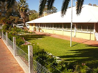
The Residency holds significance for the people of Alice Springs as a tangible symbol of their brief legislative independence from the rest of the Northern Territory. It also provided a hub of social and cultural activities for the local residents.

The State Theatre is a heritage-listed theatre, located at 47-51 Market Street, in the Sydney central business district in the City of Sydney local government area of New South Wales, Australia. The theatre was designed by Henry Eli White and built from 1926 to 1929. It hosts film screenings, live theatre and musical performances, and since 1974 it has been the home of the annual Sydney Film Festival. It is also known as State Building and Wurlitzer Organ. The property is privately owned. It was added to the New South Wales State Heritage Register on 2 April 1999.

The Alice Springs Telegraph Station is located within the Alice Springs Telegraph Station Historical Reserve, four kilometres north of the Alice Springs town centre in the Northern Territory of Australia. Established in 1872 to relay messages between Darwin and Adelaide, it is the original site of the first European settlement in central Australia. It was one of twelve stations along the Overland Telegraph Line.
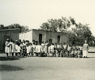
The Bungalow was an institution for Aboriginal children established in 1914 in Alice Springs in the Northern Territory of Australia. It existed at several locations in Alice Springs, Jay Creek and the Alice Springs Telegraph Station.

Owen Springs Station, now known as Owen Springs Reserve is a former pastoral station and now a 1,570 square kilometres (606 sq mi) nature reserve west of Alice Springs in the Northern Territory of Australia. The Hugh River and Waterhouse Range run through the reserve. It also features the first pastoral homestead built in Central Australia.

The Church of Christ the King is located in Tennant Creek in the Northern Territory of Australia. The church was relocated from the historic mining town of Pine Creek. With parts of the church spread between the two towns during the move, it was once known as the "longest church in Australia".
Hamilton Downs Station was a cattle station west of Alice Springs in the Northern Territory of Australia. It is now a youth camp.

Atherton Performing Arts Theatre is a heritage-listed former military depot and now theatre at 6 Silo Street, Atherton, Tablelands Region, Queensland, Australia. It was built in 1943. It is also known as Atherton WWII Igloo. It was added to the Queensland Heritage Register on 9 October 2015.
Ali Curung is an Indigenous Australian community in the Barkly Region of the Northern Territory. The community is located 170 km (106 mi) south of Tennant Creek, and 378 km (235 mi) north of Alice Springs. At the 2016 census, the community had a population of 494.
Stuart Town Gaol in Alice Springs, Northern Territory, Australia, was constructed in 1907 and held its first prisoner in 1909. It is one of the earliest permanent buildings constructed in the town and the first government building. The gaol follows a simple design and was built, using local materials, by stonemason Jack Williams.
Hartley Street School in Alice Springs, Northern Territory, Australia, was the first purpose-built school in the town. Its oldest buildings were constructed in 1929, and it opened in 1930 to cater for the growing population in the town following the completion of the railway line from Adelaide to Alice Springs.

The Pioneer Theatre, also known as "Pioneer Walk-In Theatre" and "Snow Kenna's Walk-In Picture Theatre", was a theatre in the Northern Territory of Australia located in Alice Springs. The building was built by Leslie 'Snow' Kenna in 1942 and closed, as a theatre, in 1984 and now operates as the Alice Springs YHA.

Adelaide House also known as Australian Inland Mission Hostel on the Todd Mall in Alice Springs was the first purpose built hospital to a design by the Reverend John Flynn and was completed in 1926. It now operates as a museum managed by Heritage Alice Springs Incorporated.
Griffiths House was a Methodist children's home and hostel that operated in Alice Springs, in the Northern Territory of Australia, from 1945 - 1965. It was for children from remote areas of Central Australia who were attending school in Alice Springs.
References
- 1 2 webdev. "ABOUT US". Totem Theatre. Retrieved 24 October 2019.
- 1 2 Traynor, Stuart (2016). Alice Springs : from singing wire to iconic outback town. Mile End, South Australia. ISBN 9781743054499. OCLC 958933012.
- ↑ "Totem Theatre Complex, Alice Springs". northernterritory.com. Retrieved 24 October 2019.
- 1 2 NT Department of Natural Resources, Environment, the Arts and sport (2011). Totem Theatre Complex, Alice Springs: Background Historical Information. NRETAS.CS1 maint: multiple names: authors list (link)
- ↑ "Totem Theatre Complex". Heritage Register. Northern Territory Government. 18 January 2006. Retrieved 30 January 2020.
Coordinates: 23°41′41″S133°53′06″E / 23.694852°S 133.885016°E