
Camaret Bay is a small bay on the north coast of Brittany, France.

Camaret-sur-Mer is a commune in the Finistère department in northwestern France, located at the end of Crozon peninsula.

The Battle of Camaret, also referred to as the Brest expedition, was a notable engagement of the Nine Years' War. Expecting Brest to be unguarded as the French fleet stationed there sailed south to face the Spanish, an amphibious operation at Camaret Bay was launched on 18 June 1694 by a 10,000 to 12,000-strong Anglo-Dutch force in an attempt to take and occupy the city, which represented one of the most important French naval bases. The French, however, were well aware of their plan.

The Fortifications of Vauban is a UNESCO World Heritage Site made up of 12 groups of fortified buildings and sites along the borders of France. They were designed by renowned military architect Sébastien Le Prestre de Vauban (1633–1707) during the reign of King Louis XIV. These sites include a variety of fortifications, ranging from citadels, to mountain batteries and sea fortifications, to bastion walls and towers. In addition, the site includes cities built from scratch by Vauban and communication towers. These sites were chosen because they exemplify Vauban's work, bearing witness to the influence of his designs on military and civilian engineering on a global scale from the 17th century to the 20th century.

The Goulet de Brest is a 3-km-long strait linking the roadstead of Brest to the Atlantic Ocean. Only 1.8 km wide, the goulet is situated between the Pointe du Petit Minou and the Pointe du Portzic to the north and the îlot des Capucins and the Pointe des Espagnols to the south.

The Fort de Bertheaume is a fort in Plougonvelin, in the Department of Finistère, France. It is located on a tidal island that nowadays connects to the mainland via a footbridge. The fort sits well above sea level, and its steep cliffs have rendered it easily defended for centuries. Since the 17th century, the fort's role has been to monitor the Goulet de Brest, the straits of Brest.

The Petit Minou Lighthouse is a lighthouse in the roadstead of Brest, standing in front of the Fort du Petit Minou, in the commune of Plouzané. By aligning it with the Phare du Portzic, it shows the safe route to follow for ships to enter the roadstead. It also has a red signal that indicates a dangerous sector around the plateau of les Fillettes, one of the submerged rocks in the Goulet de Brest — sailors remember this by using the mnemonic "Le Minou rougit quand il couvre les Fillettes".
La pointe de Cornouaille is a cape to the north of the hamlet of Kerviniou in France. They are both situated on the Roscanvel peninsula and, facing as it does the Fort du Mengant, a battery on the point forms part of the defences of the goulet de Brest. Known defences on the site include:
The batteries de Kerviniou are artillery batteries built in the late 19th and early 20th centuries, and are made up of an upper battery (1891) and an underground magazine (1891) Located on the Roscanvel peninsula facing the Fort du Mengant, they are a late addition to the defences of the goulet de Brest. Demilitarised in 1915, they are open to the public.

The Pointe des Espagnols is the north-east extremity of the Roscanvel peninsula, an outgrowth of the Crozon peninsula closing off the roadstead of Brest. It also marks the south-east limit of the goulet de Brest.

Îlot des Capucins is a rocky islet at the foot of a cliff in the commune of Roscanvel on the Crozon peninsula. Its name comes from a rock near the island, shaped like a praying monk. It has a strategic position at the entrance to the goulet de Brest and so a fort sited on it controlled the whole of Camaret Bay, with views stretching from pointe du Grand Gouin, to fort de Bertheaume.

A model tower (tour-modèle), also known as an Empire tower or a Napoleon tower, was a standardised defensive fortification created in 1811. Construction began along the Atlantic and Mediterranean coastlines the following year but the project was abandoned in 1814 with only 12 towers being completed.

Îlot du Diable is a gun battery built to support fort de la Fraternité in the defensive system around the goulet de Brest in France. It is sited on the peninsula of Roscanvel and is accessible by a small bridge. The battery was razed in the 19th century, and in 1890 on its site was built a bunker with an electricity generator. A casemate was then added by the Germans in 1942. A small observation is still to be found at the summit of the site, near a former lime kiln.
Quélern is a hamlet in Roscanvel, in the department of Finistère (Brittany), in western France.
Tremet is a hamlet on the Roscanvel peninsula in France. The gun batteries located here are part of the defences of the goulet de Brest, forbidding ships from entering the bay of Camaret-sur-Mer. The site had been occupied by the military since 1694 and was updated several times in the 18th and 19th centuries. The battery became a heavy anti-aircraft post in 1955 as part of the outer defences of Brest's military fort - part of that battery is still part of the military land around Quélern and not open to the public.

The pointe du Grand Gouin is a rocky promontory with vertical cliffs to the west of the inlet of Camaret-sur-Mer in France. It protects a port which, in Vauban's era, was vulnerable to possible landings. It is divided into the Grand Gouin and the Petit Gouin (mid-cliff).
Kerbonn is a village in the commune of Camaret-sur-Mer in France, between the pointe de Pen-Hir and the pointe du Toulinguet, on the Crozon peninsula. As well as its fortifications, the site also houses the ruins of the manor of Coecilian.

The Pointe du Toulinguet is a promontory at the end of the Crozon peninsula in the commune of Camaret-sur-Mer in France, in western Brittany.

The Château de Brest is a castle in Brest, Finistère, France. The oldest monument in the town, it is located at the mouth of the river Penfeld at the heart of the roadstead of Brest, one of the largest roadsteads in the world. From the Roman castellum to Vauban's citadel, the site has over 1700 years of history, holding right up to the present day its original role as a military fortress and a strategic location of the highest importance. It is thus the oldest castle in the world still in use, and was classified as a monument historique on 21 March 1923.
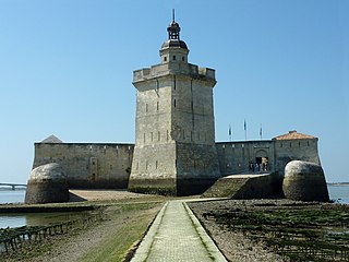
Fort Louvois, which is known locally as Fort Chapus or Fort du Chapus, is a fortification built between 1691 and 1694, during the reign of Louis XIV, on the Chapus islet, and is about 400 metres (1,300 ft) offshore in the town of Bourcefranc-le-Chapus in the department of Charente-Maritime, France. The fort sits opposite the citadel of Château d'Oléron on the island of Oléron. The fort was positioned so that a crossfire from the château and the fort would control the Pertuis de Maumusson and impede access to the Rochefort roads from the south. Fort Louvois only saw action towards the end of World War II when bombardment greatly damaged the fort, necessitating later restoration.
