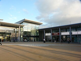
Bradley Stoke is a town in South Gloucestershire, England, situated 6 miles northeast of Bristol, It is near the Severn Estuary of the Bristol Channel, which is an extension of the North Atlantic Ocean, separating South Wales from South West England. Bradley Stoke is bordered by three motorways; the M5 to the north, the M4 to the east and the M32 to the south.

Runcorn is an industrial town and cargo port in the Borough of Halton in Cheshire, England. Its population in 2011 was 61,789. Runcorn is on the southern bank of the River Mersey, where the estuary narrows to form the Runcorn Gap.
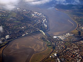
Halton is a unitary authority district with borough status in Cheshire, North West England. It was created in 1974 as a district of the non-metropolitan county of Cheshire, and became a unitary authority area on 1 April 1998 under Halton Borough Council. Since 2014, it has been a member of the Liverpool City Region Combined Authority. The borough consists of the towns of Runcorn and Widnes and the civil parishes of Daresbury, Hale, Halebank, Moore, Preston Brook, and Sandymoor. The district borders Merseyside, the Borough of Warrington and Cheshire West and Chester.

Glenrothes is a town situated in the heart of Fife, in east-central Scotland. It is about 30 miles (48 km) north of Edinburgh and 30 miles (48 km) south of Dundee. The town had a population of 39,277 in the 2011 census, making it the third largest settlement in Fife and the 18th most populous settlement in Scotland. The name Glenrothes comes from its historical link with the Earl of Rothes, who owned much of the land on which the new town has been built; Glen was added to the name to avoid confusion with Rothes in Moray and in recognition that the town lies in a river valley. The motto of Glenrothes is Ex terra vis, meaning "From the earth strength", which dates back to the founding of the town.

Hailsham is a town, a civil parish and the administrative centre of the Wealden district of East Sussex, England. It is mentioned in the Domesday Book, where it is called Hamelesham. In one part yet, mentioned in other part of the same book as ‘’’Tilux’’’, the land of Ricard de Tunbrige. The town of Hailsham has a history of industry and agriculture.

Wickford is a town and civil parish in the south of the English county of Essex, with a population of 33,486. Located approximately 30 miles (50 km) east of London, it is within the Borough of Basildon along with the original town of Basildon, Billericay, Laindon and Pitsea.
The Silver Jubilee Bridge crosses the River Mersey and the Manchester Ship Canal at Runcorn Gap between Runcorn and Widnes in Halton, England. It is a through arch bridge with a main arch span of 361 yards. It was opened in 1961 as a replacement for the Widnes-Runcorn Transporter Bridge. In 1975–77 the carriageway was widened, after which the bridge was given its official name in honour of the Queen's Silver Jubilee. It carries the A533 road and a cantilevered footway. The bridge is recorded in the National Heritage List for England as a designated Grade II listed building. The bridge was closed to vehicles for refurbishment upon the opening of the new Mersey Gateway Bridge, but reopened as a toll bridge in February 2021.

The St Helens and Runcorn Gap Railway was an early railway line owned by a company of the same name in Lancashire, England, which opened in 1833. It was later known as St Helens Railway. It ran originally from the town of St Helens to the area which would later develop into the town of Widnes. Branches were opened to Garston, Warrington and Rainford. The company was taken over by the London and North Western Railway in 1864. The line from St Helens to Widnes and the branch to Rainford are now closed, the latter terminating at the Pilkington Glass' Cowley Hill works siding near Gerard's Bridge, but part of the lines to Garston and to Warrington are still in operation.

Crystal Palace Park is a large park in south-east London, Grade II* listed on the Register of Historic Parks and Gardens. It was laid out in the 1850s as a pleasure ground, centred around the re-location of The Crystal Palace -- the largest glass building of the time -- from central London to this area on the border of Kent and Surrey; the suburb that grew around the park is known by the same name.
Halton, formerly a separate village, is now part of the town of Runcorn, Cheshire, England. The name Halton has been assumed by the Borough of Halton, which includes Runcorn, Widnes and some outlying parishes.

The DCBL Stadium is a rugby league stadium in Widnes, Cheshire, England. It is the home of Rugby League side Widnes Vikings of the Betfred Championship, and American football side Halton Spartans of the BAFA National Leagues. The stadium is all seater and has a total capacity of 13,350.

Ravenscraig is a village and new town, located in North Lanarkshire, Scotland, around 1½ miles east of Motherwell. Ravenscraig was formerly the site of Ravenscraig steelworks; once the largest hot strip steel mill in western Europe, the steelworks closed in 1992, and is now almost totally demolished.

Halton Curve is a short bi-directional railway line which links the Chester–Warrington line to the Weaver Junction–Liverpool line within the borough of Halton, Cheshire. The route, which is 1 mile 54 chains (2.7 km) long, is between Frodsham Junction and Halton Junction. After having no regular services for more than four decades, the line was upgraded and reopened in 2019 by Network Rail, enabling hourly passenger trains between Chester and Liverpool.

Widnes is an industrial town in the Borough of Halton, Cheshire, England, which at the 2011 census had a population of 61,464.

Moore is a village and civil parish in the Borough of Halton, Cheshire, England, located midway between Runcorn and Warrington. It has a population of 807.

Runcorn Shopping City, formerly Halton Lea and Runcorn Shopping Centre, is a medium-sized indoor shopping centre in Runcorn, England. Opened by Queen Elizabeth II in 1972, it is the main shopping area in Runcorn and has over 125,000 visitors per week. It was the largest enclosed shopping centre in Europe at the time of its construction and remains the largest in Cheshire.
Keckwick is an area in the Borough of Halton in Cheshire. Although there is no village as such, numerous toponyms attest to a particular identity in the area which straddles the West Coast Main Line between the village of Daresbury and the new town of Runcorn.

The Catalyst Science Discovery Centre and Museum is a science and technology museum in Widnes, Halton, North-West England. The centre has interactive exhibits, reconstructed historical scenes, an observatory, a live-science theatre and family workshops. It is next to Spike Island, a public park, located between the River Mersey and the Sankey Canal that has woodlands, wetlands, footpaths and industrial archaeological history.

Sandymoor is a civil parish in Runcorn, Halton, Cheshire, England, with a population of approximately 3,663. The majority of housing in Sandymoor was built post-1990 and the parish was formed in 2008 by the Halton Order 2008. Sandymoor lies approximately 3 miles east of Runcorn town centre, 4 miles south-west from Warrington town centre and 2 miles north of the M56 motorway.
Chapelton is a 810 hectares new town in Aberdeenshire, Scotland, 16 kilometres south of Aberdeen. It is situated close to the A92 and Newtonhill. The town plan was led by the Elsick Development Company (EDC).


