Related Research Articles

The Sheltowee Trace Trail is a 343-mile (552.00 km) National Recreation Trail that was created in 1979 and stretches from the Burnt Mill Bridge Trail Head in the Big South Fork National River and Recreation Area in Tennessee to northern Rowan County, Kentucky. The trail is named after Daniel Boone, who was given the name Sheltowee when he was adopted as the son of the great warrior Chief Blackfish of the Shawnee tribe.
Cedar Creek, located in Lincoln County in south-central Kentucky, USA, is an 8-mile-long (13 km) tributary to the Dix River. Via the Dix, Kentucky and Ohio rivers, it is part of the Mississippi River watershed. In 2002, a section of Cedar Creek was impounded to form Cedar Creek Lake.
Silver Creek is a large creek that flows for approximately 40 miles (64 km) through Madison County, Kentucky, in the United States.
Tygarts Creek is a tributary of the Ohio River in Carter and Greenup counties of northeastern Kentucky in the United States. It is 88 miles (142 km) long and drains an area of 339.6 square miles (880 km2). Via the Ohio, it is part of the watershed of the Mississippi River. Tygarts Creek is named for early Kentucky explorer Michael Tygart, who eventually drowned in the creek, somewhere near the mouth.
Goose Creek is a neighborhood of Louisville, Kentucky located where Goose Creek meets the Ohio River. It should not be confused with the adjacent incorporated city of Goose Creek.
Skycrest is a neighborhood in southwestern Lexington, Kentucky, United States. It takes its name from its location on a ridge between Wolf Run Creek and Vaughns Branch Creek that provides a panoramic view downtown Lexington. Its boundaries are Della Drive to the north, Beacon Hill Drive to the west, Furlong Drive and Spring Meadows Drive to the south, and Harrodsburg Road to the east.
McConnells Trace is a neighborhood in northwestern Lexington, Kentucky, United States. Its boundaries are Leestown Road to the east, Town Branch Creek to the west, the Bracktown neighborhood to the north, and White Oak neighborhood to the south.

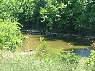
Ruddels Mills is an unincorporated community in Bourbon County, Kentucky. It was established by Captain Isaac Ruddell as a mill. The site is located where Hinkston Creek and Stoner Creek join to form the South Fork of the Licking River.
Wolf Creek is a neighborhood in far eastern Jefferson County, Kentucky, United States. Located directly east of Louisville along the Ohio River, Wolf Creek is bordered by Harrods Creek, Green Spring and Little Goose Creek. Its zip code is 40241. The neighborhood is quietly nestled amongst rolling hills and features heavy tree density, many small tributaries and natural wildlife.
Horse Creek is a creek a tributary of Goose Creek river in Clay County, Kentucky. It is 1.5 miles (2.4 km) upstream of Manchester on Goose at an altitude of 800 feet (240 m).

Buchanan, originally named Mouth of Bear, is an unincorporated community located in Lawrence County, Kentucky, United States at the mouth of Bear Creek where it joins the Big Sandy River, five miles downstream from the mouth of Blaine Creek.
Cruises Creek is a stream in Boone and Kenton counties, Kentucky, in the United States. It is a tributary of the Licking River.
Goose Creek is a small stream in the Louisville Metro area of the U.S. state of Kentucky. It is a tributary of the Ohio River.
Stoner Creek is a stream in Bourbon and Clark counties, Kentucky, in the United States.
Taylors Creek is a stream in Campbell County, Kentucky, in the United States. A variant name is Duck Creek. It is a tributary of the Ohio River. Taylors Creek forms the border between the towns of Bellevue, Kentucky and Newport, Kentucky.
Sinking Creek is a stream in Jessamine County, Kentucky, in the United States.
Dry Creek is a stream in Boone and Kenton counties, Kentucky, in the United States. It is a tributary of the Ohio River.
Threemile Creek is a stream in Campbell County, Kentucky, in the United States. It is a tributary of the Licking River.
Stepstone Creek is a stream located entirely within Pendleton County, Kentucky.
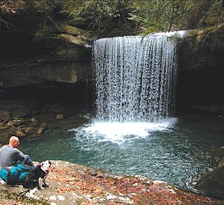
Dog Slaughter Falls is a 15 feet (4.6 m) to 20 feet (6.1 m) tall waterfall at the confluence of the Cumberland River and Dog Slaughter Creek, in the London Ranger District of the Daniel Boone National Forest in Whitley County, Kentucky. It is accessible via the Sheltowee Trace Trail, traveling downstream of Cumberland Falls, or via the Dog Slaughter Trail. The falls is rumored to be named for the drowning of unwanted pets, or the loss of hunting dogs to predatory wildlife.
References
- ↑ U.S. Geological Survey Geographic Names Information System: Townsend Creek
- ↑ Collins, Lewis (1877). History of Kentucky. p. 326.
38°18′54″N84°16′45″W / 38.314959°N 84.279213°W
| | This Bourbon County, Kentucky state location article is a stub. You can help Wikipedia by expanding it. |
| | This Harrison County, Kentucky state location article is a stub. You can help Wikipedia by expanding it. |