Traffic Separation Scheme

Last updated
Example of a TSS on a chart Chart1.jpg
Example of a TSS on a chart

A Traffic Separation Scheme or TSS is a traffic-management route-system ruled by the International Maritime Organization or IMO. The traffic-lanes (or clearways) indicate the general direction of the ships in that zone; ships navigating within a TSS all sail in the same direction or they cross the lane in an angle as close to 90 degrees as possible.

International Maritime Organization Specialised agency of the United Nations

The International Maritime Organization (IMO), known as the Inter-Governmental Maritime Consultative Organization (IMCO) until 1982, is a specialised agency of the United Nations responsible for regulating shipping. The IMO was established following agreement at a UN conference held in Geneva in 1948 and the IMO came into existence ten years later, meeting for the first time in 1959. Headquartered in London, United Kingdom, the IMO currently has 174 member states and three associate members.

Contents

TSSs are used to regulate the traffic at busy, confined waterways or around capes. Within a TSS you normally see at least one traffic-lane in each main-direction, turning-points, deep-water lanes and separation zones between the main traffic lanes. In most TSS schemes you will find Inshore Traffic Zones between the traffic-lanes and the coast. The inshore traffic zone is unregulated and shouldn't be used for ongoing traffic. It is meant for local traffic, fishing and small craft.

A ship navigating in a traffic-lane should sail in the general direction of that lane. The body of water between two opposite lanes is to be avoided by vessels travelling within the TSS as far as possible except in certain circumstances such as emergencies or for fishing activities.

The TSS rules are incorporated in the International Regulations for Preventing Collisions at Sea (Under Part B, Section I, Rule 10- Traffic Separation Schemes)

The International Regulations for Preventing Collisions at Sea 1972 (COLREGs) are published by the International Maritime Organization (IMO) and set out, among other things, the "rules of the road" or navigation rules to be followed by ships and other vessels at sea to prevent collisions between two or more vessels. COLREGs can also refer to the specific political line that divides inland waterways, which are subject to their own navigation rules, and coastal waterways which are subject to international navigation rules. The COLREGs are derived from a multilateral treaty called the Convention on the International Regulations for Preventing Collisions at Sea.

As said, when sailing within a lane of a TSS that ship has to follow the general direction of the lane. Where needed there are special zones where a lane splits into two channels: one ongoing and the other to the nearby port(s).

A TSS is controlled by a Vessel Traffic Service

Objectives

Objectives of IMO Routeing Schemes:

  1. Help reduce and manage head on situations for the streams of opposing traffic
  2. Help manage crossing situation arising while entering or coming out of port
  3. In areas of offshore activities, directives regarding safe distance from the installations
  4. Providing routes for deep draught vessels
  5. Avoiding presence of routine traffic from some areas as desired by administration
  6. Better management of inshore traffic zone, fishing zones and areas dangerous to navigation due to presence of isolated dangers and shoal patches in a high density traffic area.

Crossing

Top: Without current, Bottom: Strong current from the left VTG.svg
Top: Without current, Bottom: Strong current from the left

If a ship wants to cross a traffic-lane it should do so at a right angle to avoid endangering ship traffic using the traffic-lanes (although traffic in the lane does not automatically have the right-of-way [1] ). To minimize the amount of time a crossing ship spend crossing the traffic-lanes, there should be a right angle between the lane direction and the keel direction - even if currents might shift the actual direction of the ship's movement to some angle other than 90 degrees.

Locations

TSSs are used in locations where there is a lot of traffic (busy shipping areas) where not regulating the traffic would lead to more accidents. In Europe, many TSS areas are found around the Southern part of the North Sea including the English Channel. Other TSS are in place off Land's End and around Ouessant (Ushant).

Europe Continent in the Northern Hemisphere and mostly in the Eastern Hemisphere

Europe is a continent located entirely in the Northern Hemisphere and mostly in the Eastern Hemisphere. It is bordered by the Arctic Ocean to the north, the Atlantic Ocean to the west and the Mediterranean Sea to the south. It comprises the westernmost part of Eurasia.

North Sea marginal sea of the Atlantic Ocean

The North Sea is a marginal sea of the Atlantic Ocean located between the United Kingdom, Denmark, Norway, Sweden, Germany, the Netherlands, Belgium and France. An epeiric sea on the European continental shelf, it connects to the ocean through the English Channel in the south and the Norwegian Sea in the north. It is more than 456 kilometres (283 mi) long and 124 kilometres (77 mi) wide, with an area of around 53,910 square kilometres (20,810 sq mi).

English Channel Arm of the Atlantic Ocean that separates southern England from northern France

The English Channel, also called simply the Channel, is the body of water that separates Southern England from northern France and links the southern part of the North Sea to the Atlantic Ocean. It is the busiest shipping area in the world.

Well-known TSS locations include: The English Channel, German Bight, Singapore, and Cape Horn. The Dover Strait/Détroit du Pas de Calais was the first International Maritime Organisation (IMO) approved Traffic Separation Scheme in the world in 1967. [2] [3]

German Bight southeastern bight of the North Sea

The German Bight is the southeastern bight of the North Sea bounded by the Netherlands and Germany to the south, and Denmark and Germany to the east. To the north and west it is limited by the Dogger Bank. The Bight contains the Frisian and Danish Islands. The Wadden Sea is approximately ten to twelve kilometres wide at the location of the German Bight. The Frisian islands and the nearby coastal areas are collectively known as Frisia. The southern portion of the bight is also known as the Heligoland Bight. Between 1949 and 1956 the BBC Sea Area Forecast used "Heligoland" as the designation for the area now referred to as German Bight.

Singapore Republic in Southeast Asia

Singapore, officially the Republic of Singapore, is an island city-state in Southeast Asia. It lies one degree north of the equator, at the southern tip of the Malay Peninsula, with Indonesia's Riau Islands to the south and Peninsular Malaysia to the north. Singapore's territory consists of one main island along with 62 other islets. Since independence, extensive land reclamation has increased its total size by 23%. The country is known for its transition from a developing to a developed one in a single generation under the leadership of its founder Lee Kuan Yew.

Cape Horn Headland of the Tierra del Fuego archipelago located in Chile

Cape Horn is the southernmost headland of the Tierra del Fuego archipelago of southern Chile, and is located on the small Hornos Island. Although not the most southerly point of South America, Cape Horn marks the northern boundary of the Drake Passage and marks where the Atlantic and Pacific Oceans meet.

Other TSS areas can be found in the Mediterranean Sea, western side of the Atlantic Ocean and the Pacific.

Mediterranean Sea Sea connected to the Atlantic Ocean between Europe, Africa and Asia

The Mediterranean Sea is a sea connected to the Atlantic Ocean, surrounded by the Mediterranean Basin and almost completely enclosed by land: on the north by Southern Europe and Anatolia, on the south by North Africa and on the east by the Levant. Although the sea is sometimes considered a part of the Atlantic Ocean, it is usually identified as a separate body of water. Geological evidence indicates that around 5.9 million years ago, the Mediterranean was cut off from the Atlantic and was partly or completely desiccated over a period of some 600,000 years, the Messinian salinity crisis, before being refilled by the Zanclean flood about 5.3 million years ago.

Atlantic Ocean Ocean between Europe, Africa and the Americas

The Atlantic Ocean is the second largest of the world's oceans, with an area of about 106,460,000 square kilometers. It covers approximately 20 percent of the Earth's surface and about 29 percent of its water surface area. It separates the "Old World" from the "New World".

Pacific Ocean Ocean between Asia and Australia in the west, the Americas in the east and Antarctica or the Southern Ocean in the south.

The Pacific Ocean is the largest and deepest of Earth's oceanic divisions. It extends from the Arctic Ocean in the north to the Southern Ocean in the south and is bounded by Asia and Australia in the west and the Americas in the east.

See also

Related Research Articles

Traffic Road users travelling by foot or vehicle

Traffic on roads consists of road users including pedestrians, ridden or herded animals, vehicles, streetcars, buses and other conveyances, either singly or together, while using the public way for purposes of travel. Traffic laws are the laws which govern traffic and regulate vehicles, while rules of the road are both the laws and the informal rules that may have developed over time to facilitate the orderly and timely flow of traffic.

Strait of Malacca strait between the Malay Peninsula and the Indonesian island of Sumatra

The Strait of Malacca or Straits of Malacca is a narrow, 550 mi (890 km) stretch of water between the Malay Peninsula and the Indonesian island of Sumatra. As the main shipping channel between the Indian Ocean and the Pacific Ocean, it is one of the most important shipping lanes in the world. It is named after the Malacca Sultanate that ruled over the archipelago between 1400 and 1511.

Seamanship is the art of operating a ship or boat.

Strait of Dover strait at the narrowest part of the English Channel

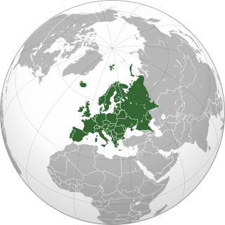
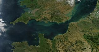
The Strait of Dover or Dover Strait, historically known as the Dover Narrows ; Dutch: Nauw van Kales[nʌu̯ vɑn kaːˈlɛː] or Straat van Dover), is the strait at the narrowest part of the English Channel, marking the boundary between the Channel and North Sea, separating Great Britain from continental Europe. The shortest distance across the strait, 33.3 kilometres, is from the South Foreland, northeast of Dover in the English county of Kent, to Cap Gris Nez, a cape near to Calais in the French département of Pas-de-Calais. Between these points lies the most popular route for cross-channel swimmers. The entire strait is within the territorial waters of France and the United Kingdom, but a right of transit passage under the UNCLOS exists allowing unrestricted shipping.

Sea mark maritime navigation aid

A sea mark, also seamark and navigation mark, is a form of aid to navigation and pilotage that identifies the approximate position of a maritime channel, hazard, or administrative area to allow boats, ships, and seaplanes to navigate safely.

Port of Hong Kong port

The Port of Hong Kong, located by the South China Sea, is a deepwater seaport dominated by trade in containerised manufactured products, and to a lesser extent raw materials and passengers. A key factor in the economic development of Hong Kong, the natural shelter and deep waters of Victoria Harbour provide ideal conditions for berthing and the handling of all types of vessels. It is one of the busiest ports in the world, in the three categories of shipping movements, cargo handled and passengers carried.

MV Tricolor was a 50,000 tonne Norwegian-flagged vehicle carrier built in 1987, notable for having been involved in three English Channel collisions within a fortnight.

Automatic identification system

The automatic identification system (AIS) is an automatic tracking system that uses transponders on ships and is used by vessel traffic services (VTS). When satellites are used to detect AIS signatures, the term Satellite-AIS (S-AIS) is used. AIS information supplements marine radar, which continues to be the primary method of collision avoidance for water transport.

A sea lane, sea road or shipping lane is a regularly used route for vessels on oceans and large lakes. In the Age of Sail they were not only determined by the distribution of land masses but also the prevailing winds, whose discovery was crucial for the success of long voyages. Sea lanes are very important for trade by sea.

Navigational aid marker that assists a traveler in navigation

A navigational aid is any sort of marker which aids the traveler in navigation, usually nautical or aviation travel. Common types of such aids include lighthouses, buoys, fog signals, and day beacons.

Sailing Directions

Sailing Directions are written directions, describing the routes to be taken by boats and ships during coastal navigation, and port approaches. There are also products known as Sailing Directions, which are books written by various Hydrographic Offices throughout the world. They are known as Pilot Books, because they provide local knowledge of routes and landmarks, which would typically be provided by a local marine pilot. As such, they are used frequently by naval and government vessels, who are exempted from 'Compulsory Pilotage' in many ports.

Road signs in the Czech Republic are regulated by the Ministry of Transport and the police. The signs are nearly the same as the European norm, but with small changes. The law governing the road signs is Decree number 30/2001 Sb., many times amended, and replaced by decree 294/2015 Sb., in force since 1 January 2016.

Sea traffic management (STM) is a methodology, developed by the Swedish Maritime Administration MonaLisa project, endorsed by the European Commission, sought to define a set of systems and procedures to guide and monitor sea traffic in a manner similar to air traffic management.

The MV Alam Pintar and FV Etoile des Ondes collision took place in the English Channel in 2009 and involved the Singapore bulk carrier Alam Pintar and the UK fishing vessel Etoile des Ondes. The fishing vessel sank and, although three of its four crew were rescued, one member, Chris Wadsworth, was never found. The bulk carrier continued on its passage although its crew knew of the collision and later made attempts to hide the fact of their knowledge. Three other vessels nearby did not respond to Etoiles' distress calls, even though these were also broadcast by the coastguards. The rescue was eventually carried out by the ferry MV Norman Voyager. The UK's Marine Accident Investigation Branch (MAIB) carried out a full investigation of the incident and issued a damning report. Safety recommendations were made but under maritime law national governments have no authority over foreign-flagged vessels more than 12 nautical miles (22 km) from their coasts. No country attempted any criminal prosecutions.

Vardø Vessel Traffic Service Centre, also known as Norwegian Oceanic Region Vessel Traffic Service, is a vessel traffic service situated in the town of Vardø in Vardø, Norway. It is responsible for monitoring ship traffic off the baseline of Norway throughout the exclusive economic zone (EEZ), including the areas around Jan Mayen and Svalbard. It has special responsibilities for the sealanes into Hammerfest and Sveagruva.

Bridge OperationalQuality Assurance is a methodology utilised in shipping and which originates from the similar FOQA concept in aviation. BOQA is a methodology with which ship owners/operators, ship Captains, and other associated shipping stakeholders can automatically and systematically monitor, track, trend and analyse operational quality of (seagoing) vessels. The main target with BOQA is to enhance maritime safety and to enable proactive decision making in ship operations. The BOQA methodology can be used in both conventional manned ships and in autonomous or unmanned vessels.

References

  1. Collision of the Cornelis Vrolijk and the ferry Primrose (Dutch), visited 20 November 2009
  2. "The Dover Strait". Dft.gov.uk. Retrieved 2012-10-15.
  3. "Fairway" (PDF). Autumn 2011. Retrieved 2012-10-15.