Atlantic Ocean: East
Europe

Vigo is a city and municipality adjoining the Atlantic Ocean in the province of Pontevedra in Galicia, northwest Spain. It is the capital of the comarca of Vigo and Vigo metropolitan area.

Spain, officially the Kingdom of Spain, is a country mostly located in Europe. Its continental European territory is situated on the Iberian Peninsula. Its territory also includes two archipelagoes: the Canary Islands off the coast of Africa, and the Balearic Islands in the Mediterranean Sea. The African enclaves of Ceuta, Melilla, and Peñón de Vélez de la Gomera make Spain the only European country to have a physical border with an African country (Morocco). Several small islands in the Alboran Sea are also part of Spanish territory. The country's mainland is bordered to the south and east by the Mediterranean Sea except for a small land boundary with Gibraltar; to the north and northeast by France, Andorra, and the Bay of Biscay; and to the west and northwest by Portugal and the Atlantic Ocean.

Cabo da Roca is a cape which forms the westernmost extent of mainland Portugal, continental Europe and the Eurasian land mass. The cape is in the Portuguese municipality of Sintra, near Azóia, in the southwest of the district of Lisbon, forming the westernmost extent of the Serra de Sintra.
Irish Sea

Tuskar Rock is a group of rocks topped by a lighthouse 11 kilometres off the southeast coast of County Wexford, Ireland. It has probably destroyed more ships than any other Irish coastal feature. One hundred and seventy-six wrecks are listed for the Tuskar Rock area at Irish Wrecks Online.
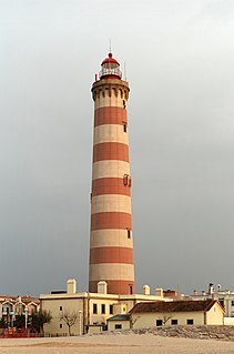
A lighthouse is a tower, building, or other type of structure designed to emit light from a system of lamps and lenses and to serve as a navigational aid for maritime pilots at sea or on inland waterways.
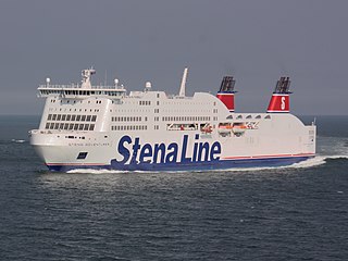
Stena Line is one of the largest ferry operators in the world. It services Denmark, Germany, Ireland, Latvia, the Netherlands, Norway, Poland, Sweden and the United Kingdom, Stena Line is a major unit of Stena AB, itself a part of the Stena Sphere. Stena Line also owns the Swedish vessels of the otherwise German- and Danish-owned Scandlines.
English Channel
The English Channel connects the Atlantic Ocean with the Southern part of the North Sea and belong to the busiest shipping areas in the world with ships going in numerous direction: you have ships that are 'just' passing through from the Southwest to Northeast (or vice versa), ships going to or departing from one of the many ports around the English Channel and then the ferries crossing the channel. In the English Channel several TSS schemes are in operation: [1] [2]
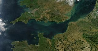
The English Channel, also called simply the Channel, is the body of water that separates Southern England from northern France and links the southern part of the North Sea to the Atlantic Ocean. It is the busiest shipping area in the world.

The Atlantic Ocean is the second largest of the world's oceans, with an area of about 106,460,000 square kilometers. It covers approximately 20 percent of the Earth's surface and about 29 percent of its water surface area. It separates the "Old World" from the "New World".

The North Sea is a marginal sea of the Atlantic Ocean located between the United Kingdom, Denmark, Norway, Sweden, Germany, the Netherlands, Belgium and France. An epeiric sea on the European continental shelf, it connects to the ocean through the English Channel in the south and the Norwegian Sea in the north. It is more than 970 kilometres (600 mi) long and 580 kilometres (360 mi) wide, with an area of 570,000 square kilometres (220,000 sq mi).
Southern North-Sea
The Southern North Sea overlaps the TSS mentioned in the English Channel above [1]
Russia and Norway
TSS in these areas aren't governed by the IMO but by either the government of Russia (marked: R) or the Norwegian government (marked N)
Baltic Sea
Most TSS in the Baltic Sea are governed by the IMO, but some are the responsibility of the local country.
Mediterranean Sea and Black Sea
Numerous TSS and similar routing-schemes are active in the Mediterranean Sea, the Black Sea and the waters within this area such as the Adriatic Sea. On the charts of the United Kingdom Hydrographic Office some 56 schemes can be found. [1] Many of these schemes are governed by the local state, such as Italy, Spain, Croatia etc.)
Some of the most important TSS are mentioned below. A complete list can be retrieved from the Notice 17: TRAFFIC SEPARATION SCHEMES AND INFORMATION CONCERNING ROUTEING SYSTEMS SHOWN ON ADMIRALTY CHARTS [1]
Pacific Ocean
China Seas
Some 25 TSS schemes are in operation in and around the China Seas. Shipping is very busy around Hong Kong, the mainland of South-East China and around Taiwan.
Some of the most important TSS schemes in this area:
Japan
In Japan there are 5 TSS Schemes all governed by the Japanese government. Apart from these mandatory schemes there are also Voluntary and Recommended schemes. These are not shown on Admiralty Charts and (thus) not shown in this overview
Korea and Russia (Pacific Coast)
In (North) Korean and Pacific Russian waters some 35 schemes are in operation with only 5 of them being governed by the IMO. All major ports in this area have a TSS in operation. In North Korea none of the TSS schemes are IMO schemes; only locally governed by the North Korean central government. Below an overview of the IMO schemes and some of the most important locally governed schemes:
Philippines, Borneo and Indonesia
There are six TSS around the Philippines and one in Malaysia. None of them are governed by the IMO:
Australia and Papua New Guinea
In this area there are 5 TSS in operation: two in the Bass Strait, governed by the IMO and three leading to Australian ports, governed by Australia.
Aleutian Islands, Alaska, US West Coast, Canada and Mexico
On the East side of the Pacific Ocean the TSSes are divided in two groups: the North side with the West Coast of Mexico and everything North of that. And the other group are formed by the West coast of Central and South America.
The TSS in the far North around the Aleutian Islands and Alaska are not put in place because of the high density of shipping but the nature of the ships and the vulnerability of the area.
The TSS schemes are:
Pacific: Central and South America
The IMO governs 16 TSS schemes on the Pacific side of Central and South America:
- landfall and approaches to Talara Bay, Peru
- landfall and approaches to Bahia de Paita, Peru
- landfall of Puerto Salaverry, Peru
- landfall and approaches to Chimbote or Ferrol Bay, Peru
- approaches to Callao, Peru
- landfall and approaches to San Martín
- landfall and approaches to San Nicolas Bay
- landfall and approaches to Puerto Ilo
- landfall and approaches to Arica
- landfall and approaches to Iquique
- landfall and approaches to Antofagasta
- in the approaches to Quintero Bay
- in the approaches to Valparaíso
- in the approaches to Bay of Concepción
- in the approaches to Bahía San Vicente, Chile
- in the approaches to Puntas Arenas
The Arabian Sea is a region of the northern Indian Ocean bounded on the north by Pakistan and Iran, on the west by the Gulf of Aden, Guardafui Channel and the Arabian Peninsula, on the southeast by the Laccadive Sea, on the southwest by the Somali Sea, and on the east by India. Its total area is 3,862,000 km2 (1,491,000 sq mi) and its maximum depth is 4,652 metres (15,262 ft). The Gulf of Aden in the west connects the Arabian Sea to the Red Sea through the strait of Bab-el-Mandeb, and the Gulf of Oman is in the northwest, connecting it to the Persian Gulf.

The Philippines is an archipelago that comprises over 7,000 islands with a total land area of 300,000 square kilometers (115,831 sq mi). The eleven largest islands contain 95% of the total land area. The largest of these islands is Luzon at about 105,000 square kilometers (40,541 sq mi). The next largest island is Mindanao at about 95,000 square kilometers (36,680 sq mi). The archipelago is around 800 kilometers (500 mi) from the Asian mainland and is located between Taiwan and Borneo.

The Gulf of Saint Lawrence is the outlet of the North American Great Lakes via the Saint Lawrence River into the Atlantic Ocean. The gulf is a semi-enclosed sea, covering an area of about 226,000 square kilometres (87,000 sq mi) and containing about 34,500 cubic kilometres (8,300 cu mi) of water, which results in an average depth of 152 metres (499 ft).
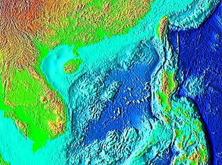
The South China Sea is a marginal sea that is part of the Pacific Ocean, encompassing an area from the Karimata and Malacca Straits to the Strait of Taiwan of around 3,500,000 square kilometres (1,400,000 sq mi). The sea carries tremendous strategic importance; one-third of the world's shipping passes through it, carrying over $3 trillion in trade each year, it contains lucrative fisheries, which are crucial for the food security of millions in Southeast Asia. Huge oil and gas reserves are believed to lie beneath its seabed.

The Spencer Gulf is the westernmost of two large inlets on the southern coast of Australia, in the state of South Australia, facing the Great Australian Bight. It spans from the Cape Catastrophe and Eyre Peninsula in the west to Cape Spencer and Yorke Peninsula in the east.
Bras d'Or Lake is an inland sea, or large body of partially fresh/salt water in the centre of Cape Breton Island in the province of Nova Scotia, Canada. Bras d'Or Lake is sometimes referred to as the Bras d'Or Lakes or the Bras d'Or Lakes system; however, its official geographic name is Bras d'Or Lake, as it is a singular entity. Canadian author and yachtsman Silver Donald Cameron describes Bras d'Or Lake as "A basin ringed by indigo hills laced with marble. Islands within a sea inside an island." The lake is connected to the North Atlantic by natural channels; the Great Bras d'Or Channel north of Boularderie Island and the Little Bras d'Or Channel to south of Boularderie Island connect the northeastern arm of the lake to the Cabot Strait. The Bras d'Or is also connected to the Atlantic Ocean via the Strait of Canso by means of a lock canal completed in 1869—the St. Peters Canal, at the southern tip of the lake.
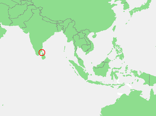
The Gulf of Mannar is a large shallow bay forming part of the Laccadive Sea in the Indian Ocean. It lies between the west coast of Sri Lanka and the southeastern tip of India, in the Coromandel Coast region. The chain of low islands and reefs known as Ramsethu, also called Adam's Bridge, which includes Mannar Island, separates the Gulf of Mannar from Palk Bay, which lies to the north between Sri Lanka and India. The Malvathu Oya of Sri Lanka and the estuaries of Thamirabarani River and Vaipar River of South India drain into the Gulf. The dugong is found here.
HMS Hydra was a Royal Navy deep ocean hydrographic survey vessel, the third of the original three of the Hecla class. The ship was laid down as yard number 2258 on 14 May 1964 at Yarrow Shipbuilders, at Scotstoun on the River Clyde and launched on 14 July 1965 by Mary Lythall, wife of the then Chief Scientist, Basil W Lythall CB (1919–2001). She was completed and first commissioned on 4 May 1966 and, as the replacement for the survey ship HMS Owen, her commanding officer and many of her ship's company formed the first commission of HMS Hydra. She was decommissioned and sold to the Indonesian Navy in 1986 and renamed KRI Dewa Kembar ; she was still in service in 2006.

Nova Scotia is a province located in Eastern Canada fronting the Atlantic Ocean. One of the Maritime Provinces, Nova Scotia's geography is complex, despite its relatively small size in comparison to other Canadian provinces.
Captain Charles Bampfield Yule, R.N. was an explorer and author of the Admiralty Australia Directory.

St. George's Bay is a bay in the Canadian province of Nova Scotia. It is located on the north shore of the province fronting both the Nova Scotia peninsula and Cape Breton Island, thus comprising a sub-basin of the Gulf of St. Lawrence.

The Adolphus Channel or the Albany passage is a channel located in the Torres Strait, situated northeast of the Cape York Peninsula, in Queensland, Australia. The channel runs north of the Albany Island, one of the islands if the Manar group of the Torres Strait Islands archipelago, and to the south of Mount Adolphus Island. Adolphus Channel is a major shipping route for traffic passing from the eastern coast of Australia to the Gulf of Carpentaria, Arafura Sea and regions further west. It is about 7 km across at its narrowest point, mostly less than about 20 m in depth and opens towards the west and towards the east. Submarine dunes up to 5 m tall migrate along the Adolphus Channel seabed, posing a potential risk to safe navigation.

The Geography of Franz Josef Land refers to an island group belonging to Arkhangelsk Oblast of Russia. It is situated in the Barents Sea of the Arctic, north of Novaya Zemlya and east of Svalbard. At latitudes between 80.0° and 81.9° north, it is the most northerly group of islands associated with Eurasia. The extreme northernmost point is Cape Fligely on Rudolf Island. The archipelago consists of 191 ice-covered islands with a total area of 16,134 km2 (6,229 sq mi). It is currently uninhabited. The archipelago is only 900 to 1,110 km from the North Pole, and the northernmost islands are closer to the Pole than any other land except for Canada's Ellesmere Island and Greenland. The largest island is Zemlya Georga which measures 110 km (68 mi) from end to end. The highest point in the archipelago is on Ostrov Viner-Neyshtadt which reaches 620 m (2,034 ft) above sea level. The central cluster of large islands in the midst of the archipelago forms a compact whole, known as Zichy Land, where islands are separated from each other by very narrow sounds that are frozen most of the year.


