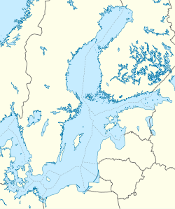
The Baltic Sea is a mediterranean sea of the Atlantic Ocean, enclosed by Denmark, Estonia, Finland, Latvia, Lithuania, Sweden, northeast Germany, Poland, Russia and the North and Central European Plain.

Götaland is one of three lands of Sweden and comprises ten provinces. Geographically it is located in the south of Sweden, bounded to the north by Svealand, with the deep woods of Tiveden, Tylöskog and Kolmården marking the border.

Gotland is Sweden's largest island. It also is a province, county, municipality, and diocese. The province includes the islands of Fårö and Gotska Sandön to the north, as well as the Karlsö Islands to the west. The population is 58,595, of which about 23,600 live in Visby, the main town. The island of Gotland and the other areas of the province of Gotland make up less than one percent of Sweden's total land area.

Gotska Sandön is an uninhabited Swedish island north of Gotland in the Baltic Sea. It has been a national park since 1909.

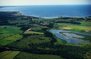
Fårösund is a locality situated on the Swedish island of Gotland with 800 inhabitants in 2014. The village can be reached by car from Visby. The island of Fårö can be reached by ferry from Fårösund.

Slite is a locality situated in Gotland Municipality, Gotland County, on the island of Gotland, Sweden with 1,500 inhabitants in 2014.
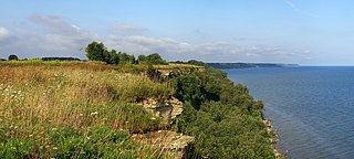
The Baltic Klint is an erosional limestone escarpment and cuesta on several islands of the Baltic Sea, in Estonia, in Leningrad Oblast of Russia and in the islands of Gotland and Öland of Sweden. It was featured on the reverse of the 50 krooni note of 1928 and on the 100 krooni note of 1992.
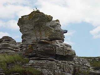
Hoburgen is a rauk area on the Storsudret peninsula in Sundre socken on the southern tip of Gotland, Sweden.
The Polish Exclusive Economic Zone has the area of 30,533 km2. within the Baltic Sea.
Vamlingbo is a populated area, a socken, on the Swedish island of Gotland. It comprises the same area as the administrative Vamlingbo District, established on 1 January 2016.

Snoderån is a 32 km (20 mi) long river on Gotland, Sweden. Snoderån basin has an area of 183.3 km2 (70.8 sq mi) and it has a total area of 240 km2 (93 sq mi), which represents about 8% of Gotland's area. 17 socken's are situated wholly or partly within the basin and comprises of: Alva, Burs, Fardhem, Fröjel, Gerum, Hablingbo, Havdhem, Hejde, Hemse, Klinte, Levide, Linde, Lojsta, Rone, Silte, Sproge and Stånga. Snoderån has its source in the Lojsta area and two outflows to the west into the Baltic Sea at Kvarnåkershamn in Sproge and Silte.
Paviken is a lake in Västergarn on the western side of the island of Gotland. The lake is a popular birding and fishing site.
Grogarnsberget or Grogarnsberg is a plateau hill on the Östergarn coast, on the Swedish island of Gotland. On the hill are the remains of former hillfort, the second largest on Gotland and the fourth largest in Scandinavia.

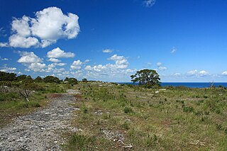
Närsholmen is a peninsula and a nature reserve on the southeast coast of Gotland, Sweden, adjacent the village of När. The landscape is savanna-like and has a rich birdlife, about 45 species has been spotted, and a number of orchids. In the late part of summer, the peninsula is covered with Echium vulgare. The reserve was established in 1986. It was also designated as a Natura 2000 area.

Näsudden is a peninsula on the south coast of Gotland, Sweden. The first tests for using wind power on a large scale in Sweden, were conducted there in the 1970s. The area has since been developed into a wind farm. Part of the peninsula is a nature reserve for birds and grey seals.
The geology of the Baltic Sea is characterized by having areas located both at the Baltic Shield of the East European Craton and in the Danish-North German-Polish Caledonides. Historical geologists make a distinction between the current Baltic Sea depression, formed in the Cenozoic era, and the much older sedimentary basins whose sediments are preserved in the zone. Although glacial erosion has contributed to shape the present depression, the Baltic trough is largely a depression of tectonic origin that existed long before the Quaternary glaciation.

Hamra is a populated area, a socken, on the Swedish island of Gotland. It comprises the same area as the administrative Hamra District, established on 1 January 2016.

Sundre is a populated area, a socken, on the Swedish island of Gotland. It comprises the same area as the administrative Sundre District, established on 1 January 2016.
Fide is a populated area, a socken, on the Swedish island of Gotland. It comprises the same area as the administrative Fide District, established on 1 January 2016.

Öja is a populated area, a socken, on the Swedish island of Gotland. It comprises the same area as the administrative Öja District, established on 1 January 2016.