Buttle, Gotland

Last updated • 1 min readFrom Wikipedia, The Free Encyclopedia

Buttle
Ange.jpg
Änge picture stones in Buttle
Sweden Gotland location map modified.svg
Red pog.svg
Buttle
Coordinates: 57°24′9″N18°31′47″E / 57.40250°N 18.52972°E / 57.40250; 18.52972
Country Sweden
Province Gotland
County Gotland County
Municipality Gotland Municipality
Area
[1]
  Total31.07 km2 (12.00 sq mi)
Population
 (2014) [2]
  Total90
Time zone UTC+1 (CET)
  Summer (DST) UTC+2 (CEST)

Buttle is a populated area, a socken (not to be confused with parish), on the Swedish island of Gotland. [3] It comprises the same area as the administrative Buttle District, established on 1 January 2016. [4]

Contents

Geography

Buttle is situated in the central part of Gotland. [5] The medieval Buttle Church is located in the socken. [6] As of 2019, Buttle Church belongs to Vänge parish in Romaklosters pastorat, along with the churches in Vänge, Guldrupe, Sjonhem, Viklau and Halla. [7] [8]

As of 2016, Buttle is best known for holding the record for both the lowest and highest temperature on Gotland. The highest temperature, 35.2 °C (95.4 °F), was recorded on 8 August 1975 and the lowest, −32.8 °C (−27.0 °F), on 9 February 1966. [9]

History

Two of the few picture stones left in their original places on Gotland, are located at Änge in Buttle. Most other stones have been used as building material in local churches or moved to various museums. [10] At 3.85 m (12.6 ft), the larger of the two is also the tallest known picture stone on the island. [11] [12]

Related Research Articles

<span class="mw-page-title-main">Fleringe</span> Place in Gotland, Sweden

Fleringe is a populated area, a socken, on the Swedish island of Gotland. It comprises the same area as the administrative Fleringe District, established on 1 January 2016.

<span class="mw-page-title-main">Lokrume</span> Place in Gotland, Sweden

Lokrume is a populated area, a socken, on the Swedish island of Gotland. It comprises the same area as the administrative Lokrume District, established on 1 January 2016.

<span class="mw-page-title-main">Lummelunda</span> Place in Gotland, Sweden

Lummelunda is a populated area, a socken, on the Swedish island of Gotland. It comprises the same area as the administrative Lummelunda District, established on 1 January 2016.

<span class="mw-page-title-main">Stenkyrka</span> Place in Gotland, Sweden

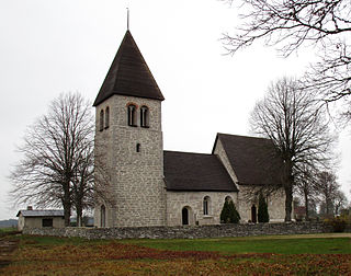
Stenkyrka is a populated area, a socken, on the Swedish island of Gotland. It comprises the same area as the administrative Stenkyrka District, established on 1 January 2016.

<span class="mw-page-title-main">Tofta, Gotland</span> Place in Gotland, Sweden

Tofta, also known as Gotlands Tofta, is a populated area, a socken, on the Swedish island of Gotland. It comprises the same area as the administrative Tofta District, established on 1 January 2016.

<span class="mw-page-title-main">Lojsta</span> Place in Gotland, Sweden

Lojsta is a populated area, a socken, on the Swedish island of Gotland. It comprises the same area as the administrative Lojsta District, established on 1 January 2016.

<span class="mw-page-title-main">Lau, Gotland</span> District of the island of Gotland, Sweden

Lau is a populated area, a socken, on the Swedish island of Gotland. It comprises the same area as the administrative Lau District, established on 1 January 2016. Originally an island, it is now part of the main Gotland island due to the isostasy. It is mostly known for the good water from the spring Lau Käldu.

<span class="mw-page-title-main">Burs, Gotland</span> Place in Gotland, Sweden

Burs is a populated area, a socken, on the Swedish island of Gotland. It comprises the same area as the administrative Burs District, established on 1 January 2016. As of 2015, Gustaf Edman from Burs was probably Sweden's tallest man.

<span class="mw-page-title-main">Eskelhem</span> Place in Gotland, Sweden

Eskelhem is a populated area, a socken, on the Swedish island of Gotland. The area is rural with farms. It comprises the same area as the administrative Eskelhem District, established on 1 January 2016.

<span class="mw-page-title-main">Ardre, Gotland</span> Place in Gotland, Sweden

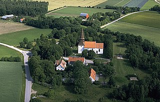
Ardre is a populated area, a socken, on the Swedish island of Gotland. It comprises the same area as the administrative Ardre District, established on 1 January 2016. It is most noted for the Viking Ardre image stones found under the floor boards of the Ardre Church.

<span class="mw-page-title-main">Hamra, Gotland</span> Place in Gotland, Sweden

Hamra is a populated area, a socken, on the Swedish island of Gotland. It comprises the same area as the administrative Hamra District, established on 1 January 2016.

<span class="mw-page-title-main">Vänge, Gotland</span> Place in Gotland, Sweden

Vänge is a populated area, a socken, on the Swedish island of Gotland. It comprises the same area as the administrative Vänge District, established on 1 January 2016.

<span class="mw-page-title-main">Garde, Gotland</span> Place in Gotland, Sweden

Garde or Garda is a populated area, a socken, on the Swedish island of Gotland. It comprises the same area as the administrative Garde District, established on 1 January 2016. It was the birth place of the marine biologist Adolf Appellöf (1857).

<span class="mw-page-title-main">Ala, Gotland</span> Place in Gotland, Sweden

Ala is a populated area, a socken, on the Swedish island of Gotland. It comprises the same area as the administrative Ala District, established on 1 January 2016.

<span class="mw-page-title-main">Alskog</span> Place in Gotland, Sweden

Alskog is a populated area, a socken, on the Swedish island of Gotland. It comprises the same area as the administrative Alskog District, established on 1 January 2016.

<span class="mw-page-title-main">Boge, Gotland</span> Place in Gotland, Sweden

Boge is a populated area, a socken, on the Swedish island of Gotland. It comprises the same area as the administrative Boge District, established on 1 January 2016.

<span class="mw-page-title-main">Eke, Gotland</span> Place in Gotland, Sweden

Eke is a populated area, a socken, on the Swedish island of Gotland. It comprises the same area as the administrative Eke District, established on 1 January 2016.

<span class="mw-page-title-main">Guldrupe</span> Place in Gotland, Sweden

Guldrupe is a populated area, a socken, on the Swedish island of Gotland. It comprises the same area as the administrative Guldrupe District, established on 1 January 2016.

<span class="mw-page-title-main">Halla, Gotland</span> Place in Gotland, Sweden

Halla is a populated area, a socken, on the Swedish island of Gotland. It comprises the same area as the administrative Halla District, established on 1 January 2016.

<span class="mw-page-title-main">Hogrän</span> Place in Gotland, Sweden

Hogrän is a populated area, a socken, on the Swedish island of Gotland. It comprises the same area as the administrative Hogrän District, established on 1 January 2016.

References

  1. Carlquist, Gunnar, ed. (1947–1955). "Buttle socken". Svensk Uppslagsbok (in Swedish) (2nd ed.). Malmö: Förlagshuset Norden.
  2. "Gotland i siffror 2015" [Gotland in numbers 2015]. www.gotland.se. Gotland Municipality. Archived from the original on 30 January 2018. Retrieved 1 July 2016.
  3. The exact extent of the socken, now district, can be obtained by clicking on Kartinställningar and check the Socken box in the menu of this map from the Swedish National Heritage Board database.
  4. "Förordning om district" [Regulation of districts](PDF). Ministry of Finance. 17 June 2015. Archived from the original (PDF) on 30 September 2018. Retrieved 1 July 2016.
  5. "Buttle". www.ne.se. Nationalencyklopedin . Retrieved 1 July 2016.
  6. Lagerlöf, Erland; Svahnström, Gunnar (1973). Gotlands kyrkor[Gotland's Churches] (in Swedish). Stockholm: Rabén & Sjögren. pp. 113–115. ISBN   91-29-41035-5. SELIBR   7232718.
  7. "Församlingar på Gotland". www.svenskakyrkan.se. Church of Sweden . Retrieved 12 January 2019.
  8. "Visby stifts indelning 2018". www.svenskakyrkan.se. Church of Sweden . Retrieved 12 January 2019.
  9. Vedin, Haldo. "Gotlands klimat" (PDF). www.smhi.se. Swedish Meteorological and Hydrological Institute. Archived from the original (PDF) on 13 August 2016. Retrieved 1 July 2016.
  10. Enderborg, Bernt. "Änges bildstenar". www.guteinfo.com. Guteinfo. Retrieved 1 July 2016.
  11. "RAÄ-nummer Buttle 42:1". www.raa.se. Swedish National Heritage Board . Retrieved 1 July 2016.
  12. Henriksson, Greta (11 January 2015). "Fornminnen Buttle". www.gotland.se. Gotland Municipality . Retrieved 1 July 2016.