Sundre, Gotland

Last updated • 1 min readFrom Wikipedia, The Free Encyclopedia

Sundre
Hoburgen-Gotland-U-2010 21-Kystvagen.jpg
Hoburgen in Sundre
Sweden Gotland location map modified.svg
Red pog.svg
Sundre
Coordinates: 56°56′9″N18°10′54″E / 56.93583°N 18.18167°E / 56.93583; 18.18167 Coordinates: 56°56′9″N18°10′54″E / 56.93583°N 18.18167°E / 56.93583; 18.18167
Country Sweden
Province Gotland
County Gotland County
Municipality Gotland Municipality
Area
[1]
  Total20.71 km2 (8.00 sq mi)
Population
 (2014) [2]
  Total24
Time zone UTC+1 (CET)
  Summer (DST) UTC+2 (CEST)

Sundre is a populated area, a socken (not to be confused with parish), on the Swedish island of Gotland. [3] It comprises the same area as the administrative Sundre District, established on 1 January 2016. [4]

Contents

Geography

Sundre is the name of the socken as well as the district. It is also the name of the small village surrounding the medieval Sundre Church, [5] sometimes referred to as Sundre kyrkby. It is the southernmost socken on the island, situated on the south tip of Gotland on the Storsudret peninsula. [6] On the south coast of Sundre is the Hoburg lighthouse as well as the rauk (sea stack) area known as Hoburgen. One of the rauks is the noted Hoburgsgubben ("Old Man Hoburg"). [1] [6] [7]

South of Hoburgen is the Hoburg Shoal bird reserve. [8]

As of 2019, Sundre Church belongs to Hoburg parish in Sudrets pastorat, along with the churches in Öja, Hamra, Vamlingbo and Fide. [9] [10]

One of the asteroids in the asteroid belt, 9374 Sundre, is named after this place. [11]

Related Research Articles

Lärbro Place in Gotland, Sweden

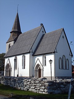
Lärbro is a locality on the Swedish island of Gotland, with 963 inhabitants in 2014.

Tingstäde Place in Gotland, Sweden

Tingstäde is a populated area, a socken, on the Swedish island of Gotland. It comprises the same area as the administrative Tingstäde District, established on 1 January 2016.

Bäl Place in Gotland, Sweden

Bäl is a populated area, a socken, on the Swedish island of Gotland. It comprises the same area as the administrative Bäl District, established on 1 January 2016.

Fole Place in Gotland, Sweden

Fole is a populated area, a socken, on the Swedish island of Gotland. It comprises the same area as the administrative Fole District, established on 1 January 2016.

Grötlingbo Place in Gotland, Sweden

Grötlingbo is a populated area, a socken, on the Swedish island of Gotland. It comprises the same area as the administrative Grötlingbo District, established on 1 January 2016.

Lummelunda Place in Gotland, Sweden

Lummelunda is a populated area, a socken, on the Swedish island of Gotland. It comprises the same area as the administrative Lummelunda District, established on 1 January 2016.

Stenkyrka Place in Gotland, Sweden

Stenkyrka is a populated area, a socken, on the Swedish island of Gotland. It comprises the same area as the administrative Stenkyrka District, established on 1 January 2016.

Vamlingbo Place in Gotland, Sweden

Vamlingbo is a populated area, a socken, on the Swedish island of Gotland. It comprises the same area as the administrative Vamlingbo District, established on 1 January 2016.

Bro, Gotland Place in Gotland, Sweden

Bro is a populated area, a socken, on the Swedish island of Gotland. It comprises the same area as the administrative Bro District, established on 1 January 2016.

Tofta, Gotland Place in Gotland, Sweden

Tofta, also known as Gotlands Tofta, is a populated area, a socken, on the Swedish island of Gotland. It comprises the same area as the administrative Tofta District, established on 1 January 2016.

Fardhem Place in Gotland, Sweden

Fardhem is a populated area, a socken, on the Swedish island of Gotland. It comprises the same area as the administrative Fardhem District, established on 1 January 2016. The area is rural with farms, tourism and small companies as the main sources of income. It is home to football club Fardhem IF.

Eskelhem Place in Gotland, Sweden

Eskelhem is a populated area, a socken, on the Swedish island of Gotland. The area is rural with farms. It comprises the same area as the administrative Eskelhem District, established on 1 January 2016.

Hablingbo Place in Gotland, Sweden

Hablingbo is a populated area, a socken, on the Swedish island of Gotland. It comprises the same area as the administrative Hablingbo District, established on 1 January 2016.

Akebäck Place in Gotland, Sweden

Akebäck is a populated area, a socken, on the Swedish island of Gotland. It comprises the same area as the administrative Akebäck District, established on 1 January 2016.

Ardre, Gotland Place in Gotland, Sweden

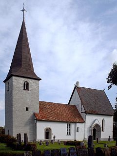
Ardre is a populated area, a socken, on the Swedish island of Gotland. It comprises the same area as the administrative Ardre District, established on 1 January 2016. It is most noted for the Viking Ardre image stones found under the floor boards of the Ardre Church.

Fide, Gotland Place in Gotland, Sweden

Fide is a populated area, a socken, on the Swedish island of Gotland. It comprises the same area as the administrative Fide District, established on 1 January 2016.

Öja, Gotland Place in Gotland, Sweden

Öja is a populated area, a socken, on the Swedish island of Gotland. It comprises the same area as the administrative Öja District, established on 1 January 2016.

Rone, Gotland Place in Gotland, Sweden

Rone is a populated area, a socken, on the Swedish island of Gotland. It comprises the same area as the administrative Rone District, established on 1 January 2016.

Gothem Place in Gotland, Sweden

Gothem is a populated area, a socken, on the Swedish island of Gotland. It comprises the same area as the administrative Gothem District, established on 1 January 2016.

Halla, Gotland Place in Gotland, Sweden

Halla is a populated area, a socken, on the Swedish island of Gotland. It comprises the same area as the administrative Halla District, established on 1 January 2016.

References

  1. 1 2 Carlquist, Gunnar, ed. (1947–1955). "Sundre socken". Svensk Uppslagsbok (in Swedish) (2nd ed.). Malmö: Förlagshuset Norden.
  2. "Gotland i siffror 2015" [Gotland in numbers 2015]. www.gotland.se. Gotland Municipality . Retrieved 4 June 2016.
  3. The exact extent of the socken, now district, can be obtained by clicking on Kartinställningar and check the Socken box in the menu of this map from the Swedish National Heritage Board database.
  4. "Förordning om district" [Regulation of districts](PDF). Ministry of Finance. 17 June 2015. Retrieved 4 June 2016.
  5. Lagerlöf, Erland; Svahnström, Gunnar (1973). Gotlands kyrkor[Gotland's Churches] (in Swedish). Stockholm: Rabén & Sjögren. pp. 248–250. ISBN   91-29-41035-5. SELIBR   7232718.
  6. 1 2 "Sundre". www.ne.se. Nationalencyklopedin . Retrieved 1 June 2016.
  7. Sjögren, Otto, ed. (1931). Sverige: geografisk beskrivning. D. 2, Östergötlands, Jönköpings, Kronobergs, Kalmar och Gotlands län[Sweden: geographical description D.2. Östergötland, Jönköping, Kronoberg, Kalmar och Gotland county]. Stockholm: Wahlström & Widstrand. SELIBR   9939.
  8. "Official Record for Hoburgs bank". www.protectedplanet.net. Protected Planet. Retrieved 1 September 2016.
  9. "Församlingar på Gotland". www.svenskakyrkan.se. Church of Sweden . Retrieved 12 January 2019.
  10. "Visby stifts indelning 2018". www.svenskakyrkan.se. Church of Sweden . Retrieved 12 January 2019.
  11. "9374 Sundre (1993 FJ46)". NASA. Archived from the original on 20 August 2020. Retrieved 2 June 2016.