
The Baltic Sea is an arm of the Atlantic Ocean, enclosed by Denmark, Estonia, Finland, Germany, Latvia, Lithuania, Poland, Russia, Sweden and the North and Central European Plain.
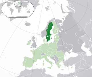
Sweden is a country in Northern Europe on the Scandinavian Peninsula. It borders Norway to the west; Finland to the northeast; and the Baltic Sea and Gulf of Bothnia to the south and east. At 450,295 km2 (173,860 sq mi), Sweden is the largest country in Northern Europe, the fifth largest in Europe, and the 55th largest country in the world.

Visby is an urban area in Sweden and the seat of Gotland Municipality in Gotland County on the island of Gotland with 24,330 inhabitants as of 2017. Visby is also the episcopal see for the Diocese of Visby. The Hanseatic city of Visby is arguably the best-preserved medieval city in Scandinavia, and, since 1995, it has been on the UNESCO World Heritage Site list. Among the most notable historical remains are the 3.4 km (2.1 mi) long town wall that encircles the town center, and a number of church ruins. The decline as a Hanseatic city in the Late Middle Ages was the cause why many stone houses were preserved in their original medieval style.

Gotland, also historically spelled Gottland or Gothland, is Sweden's largest island. It is also a province, county, municipality, and diocese. The province includes the islands of Fårö and Gotska Sandön to the north, as well as the Karlsö Islands to the west. The population is 58,595, of which about 23,600 live in Visby, the main town. Outside Visby, there are minor settlements and a mainly rural population. The island of Gotland and the other areas of the province of Gotland make up less than one percent of Sweden's total land area. The county formed by the archipelago is the second smallest by area and is the least populated in Sweden. In spite of the small size due to its narrow width, the driving distance between the furthermost points of the populated islands is about 170 kilometres (110 mi).

Gotska Sandön is an uninhabited Swedish island north of Gotland in the Baltic Sea. It has been a national park since 1909.

Stora Karlsö is an island off the west coast of Gotland, Sweden; part of Eksta socken. It is mostly known for its rich birdlife with large colonies of common guillemot, and flora. Stora Karlsö is a nature reserve, the second oldest in the world after Yellowstone National Park.

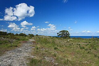
Lilla Karlsö is a small Swedish island in the Baltic Sea, situated about 3 km (1.9 mi) off the west coast of Gotland and 4.5 km (2.8 mi) from Stora Karlsö; it is part of Eksta socken. It has an area of about 1.6 km2 (0.62 sq mi) and is 66 m (217 ft) high. Most of the island consists of a limestone plateau. Parts of the shoreline is bordered by steep cliffs. The island is mostly covered by alvar. There is also some very old broadleaf forest, which is unique for Gotland. There are several caves and up to 16 m (52 ft) high limestone pillars.

Gotland pony or Gotland russ is an old Swedish pony breed. Gotland ponies are claimed to descend from Tarpans that lived on the small island of Gotland that is on the South-Eastern coast of Sweden right after the last ice age. The Gotland pony is the only breed of pony native to Sweden. The Öland horse from the neighbouring island of Öland was a close relative of the Gotland, but became extinct in the early 20th century.

The Gotland National Conscription was a Swedish Army infantry unit that traced its origins back to the 19th century. It was split into two new regiments in 1887. The regiment's soldiers were recruited on the island of Gotland.

Fårösund is a locality situated on the Swedish island of Gotland with 800 inhabitants in 2014. The village can be reached by car from Visby. The island of Fårö can be reached by ferry from Fårösund.

Lake Bästeträsk is a freshwater lake located in the northern part of the Swedish island of Gotland. It is the largest lake on the island.

Torsburgen, Tors borg or þors borg are the remains of an ancient hillfort in Kräklingbo on the Swedish island of Gotland in the Baltic Sea. The fort is approximately 1.2 km2 (0.46 sq mi), was constructed in the 1st-4th century and in use until the 12th century. Situated on a plateau hill it is protected by high cliffs and wall sections, almost 2 km (1.2 mi) long in total. The fort is featured in the Gutasaga. The plateau is also a nature reserve.

Havdhem is a locality situated on the Swedish island of Gotland with 300 inhabitants in 2014.

Gothemsån is a river on Gotland, Sweden. It's considered to be Gotland's largest river. It stretches between Lojsta Moor in the south and Hejnum in the north to the outflow in Åminne in Gothem.
Grogarnsberget or Grogarnsberg is a plateau hill on the Östergarn coast, on the Swedish island of Gotland. On the hill are the remains of former hillfort, the second largest on Gotland and the fourth largest in Scandinavia.

Sproge Church is a medieval church on the Swedish island of Gotland. Built during the 13th century, it was heavily restored in 1839-1840. It lies in the Diocese of Visby.

Tofta, also known as Gotlands Tofta, is a populated area, a socken, on the Swedish island of Gotland. It comprises the same area as the administrative Tofta District, established on 1 January 2016.

Lojsta is a populated area, a socken, on the Swedish island of Gotland. It comprises the same area as the administrative Lojsta District, established on 1 January 2016.

Rute is a populated area, a socken, on the Swedish island of Gotland. It comprises the same area as the administrative Rute District, established on 1 January 2016.

Eke is a populated area, a socken, on the Swedish island of Gotland. It comprises the same area as the administrative Eke District, established on 1 January 2016.

