Gnisvärd

Last updated
Gnisvärd
Gnisvärd and Smågårde
GotlandFiskelagen-Gnisvard-1.jpg
Gnisvärd harbor
Sweden Gotland location map modified.svg
Red pog.svg
Gnisvärd
Coordinates: 57°30′26″N18°06′44″E / 57.50722°N 18.11222°E / 57.50722; 18.11222 Coordinates: 57°30′26″N18°06′44″E / 57.50722°N 18.11222°E / 57.50722; 18.11222
CountrySweden
Province Gotland
County Gotland County
Municipality Gotland Municipality
Area [1]
  Total0,74 km2 (29 sq mi)
Population (2010) [1]
  Total125
Time zone UTC+1 (CET)
  Summer (DST) UTC+2 (CEST)

Gnisvärd (also referred to as Gnisvärd and Smågårde), is a fishing village in Tofta on the central west coast of the island of Gotland, Sweden. Gnisvärd is mostly known for its stone ships and harbor.

Fishing village village with an economy based on catching fish and harvesting seafood

A fishing village is a village, usually located near a fishing ground, with an economy based on catching fish and harvesting seafood. The continents and islands around the world have coastlines totalling around 356,000 kilometres (221,000 mi). From Neolithic times, these coastlines, as well as the shorelines of inland lakes and the banks of rivers, have been punctuated with fishing villages. Most surviving fishing villages are traditional.

Tofta, Gotland Place in Gotland, Sweden

Tofta is a populated area, a socken, on the Swedish island of Gotland. It comprises the same area as the administrative Tofta District, established on 1 January 2016.

Gotland island and historical province in Sweden

Gotland is a province, county, municipality, and diocese of Sweden. It is Sweden's largest island. The province includes the islands of Fårö and Gotska Sandön to the north, as well as the Karlsö Islands to the west. The population is 58,595, of which about 23,600 live in Visby, the main town. The island of Gotland and the other areas of the province of Gotland make up less than one percent of Sweden's total land area.

Contents

Geography

Gnisvärd is a small fishing village in the Tofta socken on the west coast of Gotland. It also includes the neighboring settlement Smågårde, about 1 km (0.62 mi) inland from Gnisvärd. [1]

Socken type of parish in Scandinavian countries

Socken is the name used for a part of a county in Sweden. In Denmark similar areas are known as sogn, in Norway sorn or sokn and in Finland pitäjä/socken. A socken is an area that was previously like a civil parish or an administrative parish. A socken was formerly linked to a parish but is now a traditional area with other borders than those of the original parishes. In some parts of Sweden the use of "socken" as a way to describe an area is more prominent than in others. A socken may also have the same name as a locality or parish.

The natural harbor, south of the modern manmade, was originally sheltered by a reef. [2] A manmade harbor with a breakwater was constructed in 1931. An extension of the harbor for pleasure craft was added later. [3] North of the harbor is the 500 m (1,600 ft) long, sandy Gnisvärd beach. [4]

Breakwater (structure) Structure constructed on coasts as part of coastal management or to protect an anchorage

Breakwaters are structures constructed near the coasts as part of coastal management or to protect an anchorage from the effects of both weather and longshore drift.

Pleasure craft boat used for personal, family, and sometimes sportsmanlike recreation

A pleasure craft is a boat used for personal, family, and sometimes sportsmanlike recreation. Such watercraft are divided into two main categories: motorboats and sailboats. There are also rowboats and canoes. They are used for holidays, for example on a river, lake, canal, waterway, in an archipelago or coastal area. Pleasure craft are normally kept at a marina. They may include accommodation for use while moored to the bank.

One of the asteroids in the main belt, 10814 Gnisvärd, is named after this place. [5]

Asteroid Minor planet that is not a comet

Asteroids are minor planets, especially of the inner Solar System. Larger asteroids have also been called planetoids. These terms have historically been applied to any astronomical object orbiting the Sun that did not resemble a planet-like disc and was not observed to have characteristics of an active comet such as a tail. As minor planets in the outer Solar System were discovered they were typically found to have volatile-rich surfaces similar to comets. As a result, they were often distinguished from objects found in the main asteroid belt. In this article, the term "asteroid" refers to the minor planets of the inner Solar System including those co-orbital with Jupiter.

Asteroid belt the circumstellar disk (accumulation of matter) in an orbit between those of Mars and Jupiter

The asteroid belt is the circumstellar disc in the Solar System located roughly between the orbits of the planets Mars and Jupiter. It is occupied by numerous irregularly shaped bodies called asteroids or minor planets. The asteroid belt is also termed the main asteroid belt or main belt to distinguish it from other asteroid populations in the Solar System such as near-Earth asteroids and trojan asteroids. About half the mass of the belt is contained in the four largest asteroids: Ceres, Vesta, Pallas, and Hygiea. The total mass of the asteroid belt is approximately 4% that of the Moon, or 22% that of Pluto, and roughly twice that of Pluto's moon Charon.

History

Gnisvärd was first used as a harbor during the Viking Age. [6] Along the north road to Gnisvärd are some of the best preserved Bronze Age stone ships on Gotland. [7]

Viking Age Period of European history from the 8th to the 11th century dealing with the Scandinavian expansion

The Viking Age is a period in European history, especially Northern European and Scandinavian history, following the Germanic Iron Age. It is the period of history when Scandinavian Norsemen explored Europe by its seas and rivers for trade, raids, colonization, and conquest. In this period, the Norsemen settled in Norse Greenland, Newfoundland, and present-day Faroe Islands, Iceland, Norway, Sweden, Normandy, Scotland, England, Wales, Ireland, Isle of Man, the Netherlands, Germany, Ukraine, Russia, Turkey and Italy.

Bronze Age Prehistoric period and age studied in archaeology, part of the Holocene Epoch

The Bronze Age is a historical period characterized by the use of bronze, and in some areas proto-writing, and other early features of urban civilization. The Bronze Age is the second principal period of the three-age Stone-Bronze-Iron system, as proposed in modern times by Christian Jürgensen Thomsen, for classifying and studying ancient societies.

Formerly one of Gotland's biggest fishing villages, Gnisvärd is made up of about 40 cottages of limestone or wood, which line both sides of the narrow road running parallel to the beach. [8] Most of the cottages were built during the 20th century. [6] At the rear of the cottages are enclosed areas for drying fishing nets. [3]

Limestone Sedimentary rocks made of calcium carbonate

Limestone is a carbonate sedimentary rock that is often composed of the skeletal fragments of marine organisms such as coral, foraminifera, and molluscs. Its major materials are the minerals calcite and aragonite, which are different crystal forms of calcium carbonate (CaCO3). A closely related rock is dolostone, which contains a high percentage of the mineral dolomite, CaMg(CO3)2. In fact, in old USGS publications, dolostone was referred to as magnesian limestone, a term now reserved for magnesium-deficient dolostones or magnesium-rich limestones.

Fishing net net used for fishing

A fishing net is a net used for fishing. Nets are devices made from fibers woven in a grid-like structure. Some fishing nets are also called fish traps, for example fyke nets. Fishing nets are usually meshes formed by knotting a relatively thin thread. Early nets were woven from grasses, flaxes and other fibrous plant material. Later cotton was used. Modern nets are usually made of artificial polyamides like nylon, although nets of organic polyamides such as wool or silk thread were common until recently and are still used.

The importance of the village reached its height when herring fishing peaked: in 1600–1680, 1747–1809 and 1877–1906. The most renowned fishing was at the Laggrundet ("Lag shallow") at the end of the 19th century, where large quantities of fish spawned during April and May. Opportunities for cod and flounder fishing were also historically good in Gnisvärd. [3]

The Gnisvärd Chapel, also known as the Strandkyrkan ("Beach Church"), [9] was built in 1839 [10] on the site of an earlier wooden chapel, probably dating from the 1600s. [3]

Fälting-Lotte

Falting-Lotte's cottage at Gnisvard harbor Fiskebod Gnisvard.JPG
Fälting-Lotte's cottage at Gnisvärd harbor

One of the more noted persons from Gnisvärd was Anna Chartlotta Ganström (30 March 1837 14 September 1912), also known as Fälting-Lotte. The daughter of a boatswain, Fälting started out as a maid and later became one of Gotland's first female professional fishermen. [11]

Etymology

Gnisvärd is sometimes referred to as "Gnidsvärd", a combination of the Swedish gnid ("rub" or "wipe") and svärd ("sword"). The origin of this name is explained in old documents collected by the priest Hans Nielsön Strelow (1587 27 February 1656) and recorded in the 1633 chronicle Chronica Guthilandorum. [12]

According to the text, Gotland suffered badly from sea-borne attacks by German pirates during the 17th century. The pirates also occupied the two islands of Stora Karlsö and Lilla Karlsö, southwest of Gnisvärd. The Gotlandic chieftains finally had enough and united in a counterattack on the pirates. Gierre from Sjonhem and Bogke, supplied his brother Hangvar with 18 manned ships, and made him commander of the campaign. They sailed from Bogeviken and attacked the pirates at the two islands where they killed them all and burned their 80 ships. When they returned to land after a successful campaign, they wiped their swords clean of the blood of their enemies in the white sand at "Gnidesuerdshaffn"—Gnidsvärd. [13]

Stone ships

The largest of the stone ships in Gnisvard Gnisvaerd-Gotland-2006-04-27-a.jpg
The largest of the stone ships in Gnisvärd

The stone ships in Gnisvärd (the Gnisvärds skeppssättningar) date to the later Bronze Age and are some of the best preserved stone ships on the island. Located just south of the north road to the fishing village, one of them is the largest on Gotland, measuring 45 m (148 ft) in length and 7 m (23 ft) in breadth. [7] Consisting of about 100 closely packed, erected stones, the bow and stern stones are the largest at approximately 1.3 m (4.3 ft). The stone ship is located between two smaller, round stone circles. [14]

About 100 m (330 ft) south of the largest stone ship lies another, 36 m (118 ft) and 4 m (13 ft) wide, [15] surrounded by two small stone circles, a stone tumulus 16 m (52 ft) in diameter and a smaller, slightly damaged stone ship. [16] Approximately 200 m (660 ft) east of the first stone ship is a burial site consisting of one tumulus and eight round stone circles. [17] There is also a large stone tumulus, 23 m (75 ft) in diameter and 2.7 m (8.9 ft) high, halfway between the stone ships and the fishing village. [18]

North of the stone ships is the only megalithic tomb on Gotland dating to 3600–2900 BC. Excavations at the site have revealed the remains of several people from different time periods up until 85 AD, making it a collective grave that has been reused several times. The largest of the stone ships is positioned with its "prow" facing the tomb. Since the stone ship was constructed after the tomb, it has been suggested that this could have been done to "moor" the ship to an older and revered place. [19]

False stone ship

Between the original stone ships and the beach is an enormous construction ( 57°30′26.5″N18°07′33.0″E / 57.507361°N 18.125833°E / 57.507361; 18.125833 (Stone ship look alike) ) that looks like a stone ship. However, this construction is not listed by the Swedish National Heritage Board. [20]

Related Research Articles

Slite Place in Gotland, Sweden

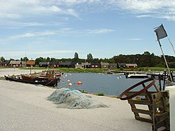
Slite is a locality situated in Gotland Municipality, Gotland County, on the island of Gotland, Sweden with 1,500 inhabitants in 2014.

Västerhejde Place in Gotland, Sweden

Västerhejde is a locality on the Swedish island of Gotland.

Fleringe Place in Gotland, Sweden

Fleringe is a populated area, a socken, on the Swedish island of Gotland. It comprises the same area as the administrative Fleringe District, established on 1 January 2016.

Lokrume Place in Gotland, Sweden

Lokrume is a populated area, a socken, on the Swedish island of Gotland. It comprises the same area as the administrative Lokrume District, established on 1 January 2016.

Lummelunda Place in Gotland, Sweden

Lummelunda is a populated area, a socken, on the Swedish island of Gotland. It comprises the same area as the administrative Lummelunda District, established on 1 January 2016.

Stenkyrka Place in Gotland, Sweden

Stenkyrka is a populated area, a socken, on the Swedish island of Gotland. It comprises the same area as the administrative Stenkyrka District, established on 1 January 2016.

Lojsta Castle

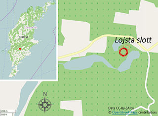
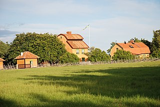
Lojsta Castle in Stånga socken on the border of Lojsta, Gotland, Sweden, is, despite its name, not a "castle" in the normal sense, i.e. it is not a palacelike manor. It is the ruins of a once fortified estate, consisting of houses surrounded by a wall and a moat.

Lojsta Place in Gotland, Sweden

Lojsta is a populated area, a socken, on the Swedish island of Gotland. It comprises the same area as the administrative Lojsta District, established on 1 January 2016.

Lau, Gotland Place in Gotland, Sweden

Lau is a populated area, a socken, on the Swedish island of Gotland. It comprises the same area as the administrative Lau District, established on 1 January 2016. Originally an island, it is now part of the main Gotland island due to the isostasy. It is mostly known for the good water from the spring Lau Käldu.

Burs, Gotland Place in Gotland, Sweden

Burs is a populated area, a socken, on the Swedish island of Gotland. It comprises the same area as the administrative Burs District, established on 1 January 2016. As of 2015, Gustaf Edman from Burs was probably Sweden's tallest man.

Eskelhem Place in Gotland, Sweden

Eskelhem is a populated area, a socken, on the Swedish island of Gotland. The area is rural with farms. It comprises the same area as the administrative Eskelhem District, established on 1 January 2016.

Hamra, Gotland Place in Gotland, Sweden

Hamra is a populated area, a socken, on the Swedish island of Gotland. It comprises the same area as the administrative Hamra District, established on 1 January 2016.

Rone, Gotland Place in Gotland, Sweden

Rone is a populated area, a socken, on the Swedish island of Gotland. It comprises the same area as the administrative Rone District, established on 1 January 2016.

Östergarn Place in Gotland, Sweden

Östergarn is a populated area, a socken, on the Swedish island of Gotland. It comprises the same area as the administrative Östergarn District, established on 1 January 2016.

Västergarn Place in Gotland, Sweden

Västergarn is a populated area, a socken, on the Swedish island of Gotland. It comprises the same area as the administrative Västergarn District, established on 1 January 2016.

Alskog Place in Gotland, Sweden

Alskog is a populated area, a socken, on the Swedish island of Gotland. It comprises the same area as the administrative Alskog District, established on 1 January 2016.

Boge, Gotland Place in Gotland, Sweden

Boge is a populated area, a socken, on the Swedish island of Gotland. It comprises the same area as the administrative Boge District, established on 1 January 2016.

Buttle, Gotland Place in Gotland, Sweden

Buttle is a populated area, a socken, on the Swedish island of Gotland. It comprises the same area as the administrative Buttle District, established on 1 January 2016.

Hogrän Place in Gotland, Sweden

Hogrän is a populated area, a socken, on the Swedish island of Gotland. It comprises the same area as the administrative Hogrän District, established on 1 January 2016.

References

  1. 1 2 3 "Småorternas landareal, folkmängd och invånare per km2 2005 och 2010, fortsättning" [Statistics area, population, 2005 and 2010](PDF). www.scb.se. Statistics Sweden. p. 23. Retrieved 29 July 2015.
  2. Nilsson, Hilding. "Information om Gnisvärd". www.bygdeband.se. The Swedish Heritage Society. Retrieved 30 July 2015.
  3. 1 2 3 4 Jonsson, Marita; Lindquist, Sven-Olof; Hejdström, Raymond (1987). Vägen till kulturen på Gotland [The road to culture on Gotland]. Gotländskt arkiv, 0434-2429 (in Swedish). Visby: Gotland Museum. p. 121. ISBN   978-91-971048-0-7.
  4. Wesley, Stefan. "Gnisvärd". www.gotland.se. Gotland Municipality . Retrieved 30 July 2015.
  5. "10814 Gnisvard (1993 FW31)". NASA . Retrieved 27 June 2016.
  6. 1 2 "Gnisvärd fiskeläger" [Gnisvärd fishing village]. www.gotland.net. Gotland.net. Retrieved 30 July 2015.
  7. 1 2 "Skeppssättning". www.gotlandsmuseum.se. Gotland Museum . Retrieved 31 July 2015.
  8. Enderborg, Bernt. "Gnisvärd fiskeläge" [Gnisvärd fishing village]. www.guteinfo.com. Guteinfo. Retrieved 31 July 2015.
  9. "Strandkyrkan i Gnisvärd". www.svenskakyrkan.se. Church of Sweden . Retrieved 30 July 2015.
  10. Enderborg, Bernt. "Gnisvärd kapell". www.guteinfo.com. Guteinfo.com. Retrieved 31 July 2015.
  11. "Anna Charlotta (Lotta)(Fältinglotte) Ganström (FÄLTING-LOTTE)". www.bygdeband.se. The Swedish Heritage Society. Retrieved 30 July 2015.
  12. Axelsson, Roger; Gislestam, Torsten (2007–2011). "Hans Nielsön Strelow". Svenskt biografiskt lexikon (in Swedish). 33. Stockholm: National Archives of Sweden. p. 649. Retrieved 31 July 2015.
  13. Enderborg, Bernt. "Gnisvärd". www.guteinfo.com. Guteinfo. Retrieved 31 July 2015.
  14. "RAÄ-nummer Tofta 14:1". www.raa.se. Swedish National Heritage Board . Retrieved 30 July 2015.
  15. "RAÄ-nummer Tofta 15:1". www.raa.se. Swedish National Heritage Board . Retrieved 30 July 2015.
  16. "RAÄ-nummer Tofta 17:1". www.raa.se. Swedish National Heritage Board . Retrieved 30 July 2015.
  17. "RAÄ-nummer Tofta 19:1". www.raa.se. Swedish National Heritage Board . Retrieved 30 July 2015.
  18. "RAÄ-nummer Tofta 12:1". www.raa.se. Swedish National Heritage Board . Retrieved 30 July 2015.
  19. Wehlin, Joakim (2011). "Stenskeppen i Ansarve hage : förtöjda i sitt förflutna?" [The stone ships in Ansarve grove: moored in their past?](PDF). Journal of Swedish Antiquarian Research. 106 (2): 75–78. Retrieved 31 July 2015.
  20. "RAÄ-nummer Tofta 10:1". www.fmis.raa.se. Swedish National Heritage Board . Retrieved 27 November 2015.

Further reading