Related Research Articles

Star is a town in Montgomery County, North Carolina, United States. The population was 876 at the 2010 census.
The Caraway Mountains are a mountain range located in western Randolph County and a section of eastern Davidson County, North Carolina. The mountains are located between the cities of Asheboro and Lexington and are bisected by US Highway 64. The mountains are known for their rugged and steep terrain and rise to over 1,000 feet (300 m). Typically the Caraways are said to be a part of the Uwharrie Mountains and make up the northern extent of this range. They extend from roughly south of High Point and transition into the Uwharries, stretching roughly 30 miles (48 km). The range is only about 10 miles (16 km) wide.
The William Lanier Hunt Arboretum is an arboretum and natural area that forms part of the North Carolina Botanical Garden. It is operated by the University of North Carolina at Chapel Hill, Old Mason Farm Road, Chapel Hill, North Carolina. The arboretum is private and not open to the public. Arboretum property was donated by William Lanier Hunt between the 1960s and the 1990s in order to protect natural areas and conserve woody plants of the southeastern United States. It includes several rhododendron bluffs in a gorge along Morgan Creek.
Johnsonville is an unincorporated community located in Johnsonville Township, Harnett County, North Carolina, United States. It is located at the intersection of NC 24 and NC 27. It is a part of the Dunn Micropolitan Area, which is also a part of the greater Research Triangle of Raleigh–Durham–Cary-Chapel Hill Combined Statistical Area as defined by the United States Census Bureau.
Sophia is an unincorporated community in central Randolph County in the U.S. state of North Carolina. It is located along U.S. Route 311, just northwest of the route's intersection with I-73/I-74/US 220 and southeast of Archdale. The ZIP Code for Sophia is 27350.
The U.S. State of North Carolina currently has 48 statistical areas that have been delineated by the Office of Management and Budget (OMB). On July 21, 2023, the OMB delineated nine combined statistical areas, 15 metropolitan statistical areas, and 24 micropolitan statistical areas in North Carolina. As of 2023, the largest of these is the Charlotte-Concord, NC-SC CSA, comprising the state's largest city of Charlotte and its suburbs.
Pineview is an unincorporated community located in the Barbecue Township of Harnett County, North Carolina, United States. It is a part of the Dunn Micropolitan Area, which is also a part of the greater Raleigh–Durham–Cary Combined Statistical Area (CSA) as defined by the United States Census Bureau.
Ryes is an unincorporated community located along old U.S. Route 421 in the Upper Little River Township of Harnett County, North Carolina, United States, situated between the communities of Seminole and Mamers. It is a part of the Dunn Micropolitan Area, which is also a part of the greater Raleigh–Durham–Cary Combined Statistical Area (CSA) as defined by the United States Census Bureau.
Seminole is an unincorporated community located along U.S. Route 421 in the Upper Little River Township of Harnett County, North Carolina, United States, near the county line with Lee County just outside the town of Broadway. It is a part of the Dunn Micropolitan Area, which is also a part of the greater Raleigh–Durham–Cary Combined Statistical Area (CSA) as defined by the United States Census Bureau.
Barbecue is an unincorporated community located in the Barbecue Township of Harnett County, North Carolina, United States. It is a part of the Dunn Micropolitan Area, which is also a part of the greater Raleigh–Durham–Cary Combined Statistical Area (CSA) as defined by the United States Census Bureau.

Coleridge is an unincorporated community along the Deep River in Randolph County, North Carolina, United States. It lies near Ramseur and southeast of Greensboro. Major roads through the town are Highway 22, which is joined in the middle by Highway 42, which then travels to Bennett.This community was named for James A. Cole, a local merchant. It is in the Eastern Standard Time zone UTC-5. The elevation is 436 feet. Former and merged names include Foust's Mill.
Seaforth is a former unincorporated community in Chatham County, North Carolina, United States located on U.S. Highway 64. It lies at an elevation of 217 feet.

Eagle Springs is an unincorporated community in Moore County, North Carolina, United States, situated near the southern terminus of North Carolina Highway 705, on North Carolina Highway 211, west of Elberta, the southern terminus of North Carolina Highway 705. It lies at an elevation of 673 feet. The ZIP Code for Eagle Springs is 27242.
Steeds is an unincorporated community located in the northeastern part of Montgomery County, North Carolina, United States.
Ulah is an unincorporated community in Randolph County, North Carolina, United States. south of the neighboring county seat of Asheboro.
Black Ankle is an unincorporated community in the northeastern part of Montgomery County, North Carolina, United States.
Harpers Crossroads is an unincorporated community in Chatham County, North Carolina, United States. It is located at the intersection of State Highway 902, and Siler City Glendon Rd.
Crutchfield Crossroads is an unincorporated community in northwestern Chatham County, North Carolina, United States, north of the town of Siler City. Crutchfield Crossroads is commonly defined as the area in and around the rural intersection of Silk Hope-Liberty Road. and Siler City- Snow Camp Road. At the intersection of the two roads, there are some stores, but other than that the entire community is agricultural. Children living in this area attend schools in Silk Hope and Siler City.
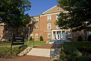
The UNC Eshelman School of Pharmacy is located at the University of North Carolina at Chapel Hill, and includes a satellite campus at UNC Asheville. The Asheville School of Pharmacy campus opened in 2011, and graduated its first class in 2015.
Manly is an unincorporated community in Moore County, in the U.S. state of North Carolina.
References
35°26′41″N79°12′52″W / 35.4445983°N 79.2144670°W
Municipalities and communities of Lee County, North Carolina, United States | ||
|---|---|---|
| City |  | |
| Town | ||
| Unincorporated communities | ||
| Footnotes | ‡This populated place also has portions in an adjacent county or counties | |
| International | |
|---|---|
| National | |