
Askim is a town and a former municipality in Indre Østfold municipality in the county of Østfold, Norway.

Våler is a municipality in Østfold county, Norway. The administrative centre of the municipality is Kirkebygden. The parish of Vaaler was established as a municipality on 1 January 1838.

Nesodden is a municipality in Akershus in Akershus county, Norway. It is part of the Greater Oslo Region and many residents of the peninsula Nesodden commute to work in Oslo.

Sørum was a municipality in Akershus county, Norway. It is part of the traditional region of Romerike. The administrative centre of the municipality was the village of Sørumsand. Sørum was established as a municipality on 1 January 1838. The municipality of Blaker was merged with Sørum on 1 January 1962.
Gjerdrum is a municipality in Akershus county, Norway. It is part of the traditional region of Romerike.

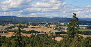
is a municipality in Buskerud county, Norway. It is part of the traditional region of Hallingdal. The administrative center of the municipality is the village of Gol which is also the population center. Gol was established as a municipality on 1 January 1838. The area of Hemsedal was separated from Gol in 1897 to become a separate municipality. The municipality of Gol is bordered to the north by the municipality of Nord-Aurdal, to the east by Sør-Aurdal, to the south by Nes, and to the west by Ål and Hemsedal.

Krødsherad is a municipality in Buskerud county, Norway. The administrative centre of the municipality is the village of Noresund. The municipality of Krødsherad was established when it was separated from the municipality of Sigdal on 1 January 1901.
Øvre Eiker is a municipality in Buskerud county, Norway. It is part of the traditional region of Eiker. The administrative centre of the municipality is the village of Hokksund. The old municipality of Eiker was divided into Øvre Eiker and Nedre Eiker (lower) on 1 July 1885.

Lier is a municipality in Buskerud county, Norway. The administrative centre of the municipality is the village of Lierbyen. The municipality of Lier was established on 1 January 1838. The area Åssiden was transferred from Lier to the neighboring municipality of Drammen on 1 July 1951.

Rollag is a municipality in Buskerud county, Norway. It is part of the traditional region of Numedal. The administrative centre of the municipality is the village of Rollag, although the most populated area in the municipality is Veggli. Rollag is bordered in the north by Nore og Uvdal, in the east by Sigdal, in the south by Flesberg, and in the west by Tinn in Telemark.

Solbergelva is a village in Drammen municipality in Buskerud, Norway. The village lies north of Drammenselva, approx. 5 miles west of Bragernes square, between Åssiden in the east and Krokstadelva in the west with Solbergfjellet north. It is part of Drammen municipality and has about 6.000 inhabitants in 2017.
Løken is a village in the municipality of Aurskog-Høland, Norway. Its population is 1,539.
Darbu is a village within the parish of Fiskum, in the municipality of Øvre Eiker, Buskerud County, Norway. The population of the village was 539 as of 2019.
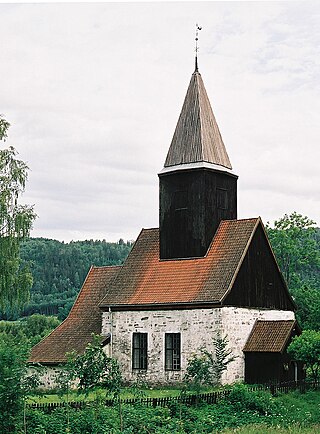
Kyrkjebø is a former municipality in the old Sogn og Fjordane county, Norway. The 681-square-kilometre (263 sq mi) municipality existed from 1858 until 1964 when it became part of the new municipality of Høyanger which still exists and is part of the new Vestland county. Prior to its dissolution, the municipality of Kyrkjebø included land on the north and south side of the Sognefjorden. The administrative centre of the municipality was the village of Kyrkjebø, where the main Kyrkjebø Church is located.

Uvdal is a village and former municipality in Buskerud county, Norway. It is situated in the traditional region of Numedal and is the location of the Uvdal Stave Church.

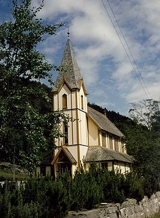
Sunnylven is a former municipality in Møre og Romsdal county, Norway. The 637-square-kilometre (246 sq mi) municipality existed from 1838 until its dissolution in 1965. Since that time, it has made up the southern part of the present-day Stranda Municipality. It encompassed the areas around the Sunnylvsfjorden and Geirangerfjorden. The village of Hellesylt was the administrative centre of the municipality and Geiranger was the other main population centre in Sunnylven. The main church for the municipality was Sunnylven Church in Hellesylt.

Norderhov is a former municipality located within Ringerike in Buskerud county, Norway.

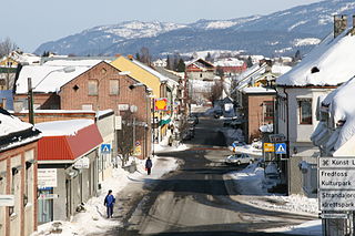
Sylling is a village in Lier municipality, in the county of Buskerud, Norway. Sylling is located 27 kilometres west of Oslo. The settlement has 707 inhabitants as of 1 January 2016.

Misje is an island in Øygarden Municipality in Vestland county, Norway. The 1.16-square-kilometre (0.45 sq mi) island lies just south of the island of Toftøyna and north of the large island of Sotra. Almost all of the 257 inhabitants live on the eastern part of the island, which is referred to as the village of Misje.

Ormøya is an inhabited island in the inner part of Oslofjord, in the municipality of Oslo. It is located north of the island Malmøya and west of the mainland at Bekkelaget / Nordstrand. A bridge over the strait Ormsundet connects the island to the mainland. The island covers an area of 0.18 square kilometres (0.069 sq mi) Ormøy Church, designed by architect Bernhard Steckmest, was built in the 1890s. On the island there are beaches, boating ports and a small park.


