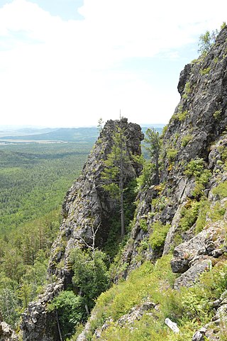
Alkhanay National Park encompasses the area around Mt. Alkhanai, a central focus and sacred mountain to the Buryats people, who today are the largest indigenous group in Siberia. Mt. Alkanai has been adopted as sacred by later Mongols, shamanistic people, and Buddhists. The Dalai Lama has made two unofficial visits to Alkhanay. The area takes its name from an old legend, in which a princess took refuge from her pursuers on the top of the mountain, defiantly shouting as they approached, "kill me!", which translates to "Alkhanai" in the local language. Despite the ancient name, the focus today of Buddhist pilgrims as they ascend the mountain pathway is one of peacefulness and healing. The park seeks to balance support for continued pilgrimage to the rock landforms and mineral springs, with conservation of nature and recreational tourism. Alkhanay NP is located in the Trans-Baikal region of Russia, about 300 miles east of the lake, and 75 miles north of Mongolia's northern border. It is in the administrative region of Aginsky District, Zabaykalsky Krai.
Bureya Nature Reserve is a protected area (Zapovednik) about 200 km northwest of the city of Khabarovsk, in the Verkhnebureinsky District of Khabarovsk Krai, in the Russian Far East. The territory is one of mountain tundra, rivers and lakes, and taiga forests. It includes the headwaters of the left and right tributaries of the Bureya River, part of the lower Amur River basin. The reserve was created in 1987, and covers an area of 358,444 ha (1,383.96 sq mi).

Bastak Nature Reserve is a Russian 'zapovednik' located in the Amur River basin in the Russian Far East. The reserve's territory covers the south-eastern spurs Bureya Range and the northern outskirts of the Sredneamurskaya lowlands. The reserve is situated in about 10 km north of the city of Birobidzhan in the Birobidzhansky District, and is the only national reserve in the Jewish Autonomous Oblast.

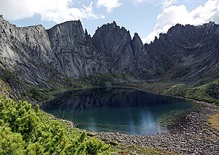
Sokhondo Nature Reserve is a Russian 'zapovednik' in the south of Eastern Siberia, 25 km north of the border with Mongolia. It is the farthest source of the Amur River, and is centered on the Sokhondo Mountain massif, in the highest sector of the Khentei-Chikoy Highlands in the Khentei Range mountain range. The Sokhondo massif has two peaks, and is an ancient volcano. Also within the borders are many lakes of glacial origin. In 1985, Sokhondo was named a UNESCO MAB Biosphere Reserve. The reserve is situated in the Chita district of Chita Oblast.
The Transbaikal conifer forests ecoregion covers a 1,000 km by 1,000 km region of mountainous southern taiga stretching east and south from the shores of Lake Baikal in the Southern Siberia region of Russia, and including part of northern Mongolia. Historically, the area has been called "Dauria", or Transbaikal. It is in the Palearctic realm, and mostly in the boreal forests/taiga biome with a subarctic, humid climate. It covers 200,465 km2 (77,400 sq mi).

Dzherginsky Nature Reserve is a Russian 'zapovednik', located about 100 km east of the northern section of Lake Baikal. It covers the source and upper reaches of the Barguzin River, the second largest tributary to Lake Baikal, and is at the junction of three mountain ranges - the Barguzin Range to the west of the reserve, the Ikat Range and the Southern Muya Range. The reserve's mountainous territory is dominated by larch forests. It is situated in the Kurumkansky District of Buryatia. The nearest city, Ulan-Ude, is 560 km to the south. The reserve was formally established in 1992 to protect the biodiversity of the upper Barguzin valley, and to study natural processes of the area. It covers an area of 238,088 hectares (919.26 sq mi).

Vitim Nature Reserve is a Russian 'zapovednik' in the mountains 400 km northeast of Lake Baikal in the Irkutsk region of Siberia. It covers the upper reaches of the Vitim River, a left tributary of the Lena River. The reserve protects a wide variety high-altitude, continental climate flora and fauna complexes: larch taiga, cedar thickets, mountain tundra, and sub-alpine meadows of the Delyun-Uran and Kodar Mountains. The reserve is located in the southeast of the Bodaybinsky District of Irkutsk Oblast, 150 km east of the regional city of Bodaybo. It was formally established in 1982, and covers 585,838 ha (2,261.93 sq mi).

Taymyr Nature Reserve is a Russian 'zapovednik' located in the northern lowlands of Siberia, on the Taimyr Peninsula, and on the coast of the Laptev Sea of the Arctic Ocean. The reserve includes the most northern forest of Dahurian larch in the world, and also the most northern mainland mountain range in the world. The protected area was established to protect the breeding grounds of the Red-breasted goose as well as the summer residences of wild reindeer and the biodiversity of the Lake Taymyr. The reserve is situated about 120 km east of the town of Norilsk, and 3,000 km northeast of Moscow, in the Taymyrsky Dolgano-Nenetsky District of Krasnoyarsk Krai. In 1995, the site was designated a UNESCO MAB Reserve. The reserve was formally established in 1979, and covers an area of 1,781,928 ha (6,880.06 sq mi).

The Northeast Siberian taiga ecoregion is an area of "sparse taiga forest" between the Lena River and the Kolyma River in northeastern Siberia, Russia. The ecoregion's internal borders form a patchwork of territory constituting the southern part of the East Siberian Lowland, as well as lowlands around the East Siberian Mountains, including the ridges and peaks of the Verkhoyansk Range and the Chersky Range. On the southern border of the ecoregion is the north coast of the Sea of Okhotsk, giving the region maritime boreal forests as well as the continental forests situated inland. The ecoregion is one of the largest tracts of virgin boreal forest in the world, due to the very sparse population and difficult access. It is mostly in the Sakha Republic.

Katon-Karagay National Park is the largest national park in Kazakhstan, located on the eastern edge of the country, in the Southern Altai Mountains. The park fills the west side of the "X" where the borders of Kazakhstan, Russia, China, and Mongolia meet. The highest peak in Siberia, is on the Russian border in the Katun Range. The park is in Katonkaragay District of East Kazakhstan Region, 1,000 kilometres (620 mi) southeast of the capital city of Astana.

The Altai alpine meadow and tundra ecoregion is a terrestrial ecoregion covering the higher elevation of the Altai Mountains at the center of the "X" formed by the borders separating Russia, Kazakhstan, China, and Mongolia. The mountain peaks are the farthest north in Central Asia, separating the plains of Siberia to the north from the hot, dry deserts to the south. Altitudes above 2,400 meters display characteristics of tundra, with patches of alpine meadows and some trees immediately below the treeline. The ecoregion is in the montane grasslands and shrublands biome, and the Palearctic realm, with a humid continental climate. It covers an area of 90,132 square kilometres (34,800 sq mi).

The Sayan Alpine meadows and tundra ecoregion is an ecoregion that covers the high areas of the Sayan Mountains above the treeline, between the Altai Mountains in the west and Lake Baikal in the east. The area is remote and protects diverse species of alpine flora and fauna. It has an area of 846,149 square kilometres (326,700 sq mi).

The Cherskii–Kolyma mountain tundra ecoregion is an ecoregion that covers the higher elevations of the Chersky Range and the Kolyma Mountains, the only large mountain range in northern Russia. It is in the Palearctic realm, and tundra biome. It has an area of 556,589 square kilometres (214,900 sq mi).
The Taimyr-Central Siberian tundra ecoregion is an ecoregion that broadly covers the Taymyr Peninsula in the Russian Far North. It ranges from the delta of the Yenisei River in the west, across the Taymyr Peninsula and Khatanga Gulf, to the Lena River delta in the east. The region is an important area for breeding birds. It is in the Palearctic realm in the tundra biome, and is mostly located in Taymyrsky Dolgano-Nenetsky District of Krasnoyarsk Krai. It has an area of 954,670 square kilometres (368,600 sq mi).

The Pamir alpine desert and tundra ecoregion covers the high plateau of the Pamir Mountains, at the central meeting of the great mountain ranges of Central Asia: Himalaya, Karakoram, Hindu Kush, Kunlun, and Tian Shan. It is a region of relatively high biodiversity due to its central location and high elevation differentials, but it also acts as a barrier between the climate and habitats of north and south Asia.

The Davis Highlands tundra ecoregion covers the Baffin Mountains on the northeast coast of Baffin Island and Bylot Island, facing Baffin Bay in Nunavut, northern Canada. The terrain is extremely rugged, heavily glaciated, with many deep fjords, and very cold. About half of the territory is moss and lichen tundra, the other half bare rock and ice. The region is wetter than the much drier regions to the southwest of the Baffin Islands.
The Torngat Mountain tundra ecoregion covers the Torngat Mountains on the northeastern tip of the Labrador Peninsula where the provinces of Quebec and Newfoundland and Labrador meet. The mountains feature glacially carved U-shaped valleys and deep fjords. The vegetation over most of the territory is that of arctic tundra, herbaceous cover, or bare rock. The region supports seasonal polar bears, black bears, and caribou. The Atlantic coast is on the Atlantic Flyway for migratory birds.

Kodar National Park is located in Kodar Mountains of Russia, about 500 km northeast of Lake Baikal. The park encompasses extreme variations in terrain: precipitous alpine slopes, over 570 alpine lakes, low-altitude glaciers, volcanoes, and an isolated small desert surrounded by taiga forest. The park was officially created in 2016. The park is located in the administrative district of Kalarsky District, Zabaykalsky Krai.

Khibiny National Park protects a mountainous region of taiga and tundra on the Khibiny Mountains and Lovozero Massif of the western Kola Peninsula in northwestern Russia. The mountains contain commercially important minerals, and the park's borders reflect the need to balance three uses - protection of the unique natural environment, recreation, and industrial mining. The park was officially created in 2018, and is located in the districts of Kirovsk and Olenegorsk in Murmansk Oblast.
Tokinsko-Stanovoy National Park is located at the mountainous headwaters of the Zeya River, in the Stanovoy Highlands of the Russian Far East. It was created in 2019 to protect important natural features - particularly the Siberian snow sheep, and also the cultural heritage of the reindeer-herding indigenous Evenki people. The park is located in the Zeysky District of Amur Oblast, at the meeting point of the borders of Amur Oblast, the Sakha Republic, and Khabarovsk Krai.

