Related Research Articles

A mammoth is any species of the extinct elephantid genus Mammuthus, one of the many genera that make up the order of trunked mammals called proboscideans. The various species of mammoth were commonly equipped with long, curved tusks and, in northern species, a covering of long hair. They lived from the Pliocene epoch into the Holocene at about 4,000 years ago, and various species existed in Africa, Europe, Asia, and North America. They were members of the family Elephantidae, which also contains the two genera of modern elephants and their ancestors. Mammoths are more closely related to living Asian elephants than African Elephants.

The Rocky Mountains, also known as the Rockies, are a major mountain range and the largest mountain system in North America. The Rocky Mountains stretch 3,000 mi (4,800 km) in straight-line distance from the northernmost part of western Canada, to New Mexico in the southwestern United States. Depending on differing definitions between Canada and the United States, its northern terminus is located either in northern British Columbia's Terminal Range south of the Liard River and east of the Trench, or in the northeastern foothills of the Brooks Range/British Mountains that face the Beaufort Sea coasts between the Canning River and the Firth River across the Alaska-Yukon border. Its southernmost point is near the Albuquerque area adjacent to the Rio Grande Basin and north of the Sandia–Manzano Mountain Range. Being the easternmost portion of the North American Cordillera, the Rockies are distinct from the tectonically younger Cascade Range and Sierra Nevada, which both lie farther to its west.

The Coast Mountains are a major mountain range in the Pacific Coast Ranges of western North America, extending from southwestern Yukon through the Alaska Panhandle and virtually all of the Coast of British Columbia south to the Fraser River. The mountain range's name derives from its proximity to the sea coast, and it is often referred to as the Coast Range. The range includes volcanic and non-volcanic mountains and the extensive ice fields of the Pacific and Boundary Ranges, and the northern end of the volcanic system known as the Cascade Volcanoes. The Coast Mountains are part of a larger mountain system called the Pacific Coast Ranges or the Pacific Mountain System, which includes the Cascade Range, the Insular Mountains, the Olympic Mountains, the Oregon Coast Range, the California Coast Ranges, the Saint Elias Mountains and the Chugach Mountains. The Coast Mountains are also part of the American Cordillera—a Spanish term for an extensive chain of mountain ranges—that consists of an almost continuous sequence of mountain ranges that form the western backbone of North America, Central America, South America and Antarctica.

The St. Francois Mountains in southeast Missouri are a mountain range of Precambrian igneous mountains rising over the Ozark Plateau. This range is one of the oldest exposures of igneous rock in North America. The name of the range is spelled out as Saint Francois Mountains in official GNIS sources, but it is sometimes misspelled in use as St. Francis Mountains to match the anglicized pronunciation of both the range and St. Francois County.

The Front Range is a mountain range of the Southern Rocky Mountains of North America located in the central portion of the U.S. State of Colorado, and southeastern portion of the U.S. State of Wyoming. It is the first mountain range encountered as one goes westbound along the 40th parallel north across the Great Plains of North America.

Glacier Peak or Dakobed is the most isolated of the five major stratovolcanoes of the Cascade Volcanic Arc in the U.S state of Washington. Located in the Glacier Peak Wilderness in Mount Baker–Snoqualmie National Forest, the volcano is visible from the west in Seattle, and from the north in the higher areas of eastern suburbs of Vancouver such as Coquitlam, New Westminster and Port Coquitlam. The volcano is the fourth tallest peak in Washington state, and not as much is known about it compared to other volcanoes in the area. Local Native Americans have recognized Glacier Peak and other Washington volcanoes in their histories and stories. When American explorers reached the region, they learned basic information about surrounding landforms, but did not initially understand that Glacier Peak was a volcano. Positioned in Snohomish County, the volcano is only 70 miles (110 km) northeast of downtown Seattle. From locations in northern Seattle and northward, Glacier Peak is closer than the more famous Mount Rainier (Tahoma), but as Glacier Peak is set farther into the Cascades and almost 4,000 feet (1,200 m) shorter, it is much less noticeable than Mount Rainier.
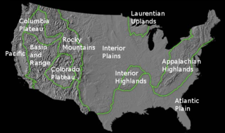
The richly textured landscape of the United States is a product of the dueling forces of plate tectonics, weathering and erosion. Over the 4.5 billion-year history of our Earth, tectonic upheavals and colliding plates have raised great mountain ranges while the forces of erosion and weathering worked to tear them down. Even after many millions of years, records of Earth's great upheavals remain imprinted as textural variations and surface patterns that define distinctive landscapes or provinces.
The Sauk sequence was the earliest of the six cratonic sequences that have occurred during the Phanerozoic in North America. It was followed by the Tippecanoe, Kaskaskia, Absaroka, Zuñi, and Tejas sequences.
Sloan Peak is a 7,835-foot (2,388-metre) mountain in the North Cascades of Washington state. It rises about 40 miles (64 km) east of Everett, Washington and 12 miles southwest of Glacier Peak, one of the Cascade stratovolcanoes. It is located between the north and south forks of Sauk River, in the Mount Baker–Snoqualmie National Forest. The summit is situated about 4 miles (6.4 km) east of the Mountain Loop Highway.
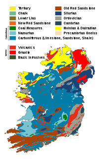
The geology of Ireland consists of the study of the rock formations on the island of Ireland. It includes rocks from every age from Proterozoic to Holocene and a large variety of different rock types is represented. The basalt columns of the Giant's Causeway together with geologically significant sections of the adjacent coast have been declared a World Heritage Site. The geological detail follows the major events in Ireland's past based on the geological timescale.

The geological history of Earth follows the major geological events in Earth's past based on the geological time scale, a system of chronological measurement based on the study of the planet's rock layers (stratigraphy). Earth formed about 4.54 billion years ago by accretion from the solar nebula, a disk-shaped mass of dust and gas left over from the formation of the Sun, which also created the rest of the Solar System.
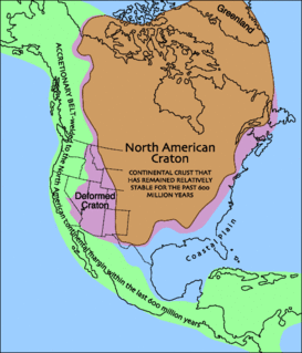
Laurentia or the North American Craton is a large continental craton that forms the ancient geological core of North America. Many times in its past, Laurentia has been a separate continent, as it is now in the form of North America, although originally it also included the cratonic areas of Greenland and also the northwestern part of Scotland, known as the Hebridean Terrane. During other times in its past, Laurentia has been part of larger continents and supercontinents and itself consists of many smaller terranes assembled on a network of Early Proterozoic orogenic belts. Small microcontinents and oceanic islands collided with and sutured onto the ever-growing Laurentia, and together formed the stable Precambrian craton seen today.

The volcanology of Eastern Canada includes the hundreds of volcanic areas and extensive lava formations in Eastern Canada. The region's different volcano and lava types originate from different tectonic settings and types of volcanic eruptions, ranging from passive lava eruptions to violent explosive eruptions. Eastern Canada has very large volumes of magmatic rock called large igneous provinces. They are represented by deep-level plumbing systems consisting of giant dike swarms, sill provinces and layered intrusions. The most capable large igneous provinces in Eastern Canada are Archean age greenstone belts containing a rare volcanic rock called komatiite.

The Canadian Cascade Arc, also called the Canadian Cascades, is the Canadian segment of the North American Cascade Volcanic Arc. Located entirely within the Canadian province of British Columbia, it extends from the Cascade Mountains in the south to the Coast Mountains in the north. Specifically, the southern end of the Canadian Cascades begin at the Canada–United States border. However, the specific boundaries of the northern end are not precisely known and the geology in this part of the volcanic arc is poorly understood. It is widely accepted by geologists that the Canadian Cascade Arc extends through the Pacific Ranges of the Coast Mountains. However, others have expressed concern that the volcanic arc possibly extends further north into the Kitimat Ranges, another subdivision of the Coast Mountains, and even as far north as Haida Gwaii.
Dinosaur paleobiogeography is the study of dinosaur geographic distribution, based on evidence in the fossil record.
The geology of New Mexico includes bedrock exposures of four physiographic provinces, with ages ranging from almost 1800 million years (Ma) to nearly the present day. Here the Great Plains, southern Rocky Mountains, Colorado Plateau, and Basin and Range Provinces meet, giving the state great geologic diversity.
The geology of Missouri includes deep Precambrian basement rocks formed within the last two billion years and overlain by thick sequences of marine sedimentary rocks, interspersed with igneous rocks by periods of volcanic activity. Missouri is a leading producer of lead from minerals formed in Paleozoic dolomite.
The geology of North Dakota includes thick sequences oil and coal bearing sedimentary rocks formed in shallow seas in the Paleozoic and Mesozoic, as well as terrestrial deposits from the Cenozoic on top of ancient Precambrian crystalline basement rocks. The state has extensive oil and gas, sand and gravel, coal, groundwater and other natural resources.

North Arch volcanic field is an underwater volcanic field north of Oahu, Hawaii. It covers an area of about 25,000 square kilometres (9,700 sq mi) and consists of large expanses of alkali basalt, basanite and nephelinite that form extensive lava flows and volcanic cones. Some lava flows are longer than 100 kilometres (62 mi).
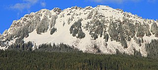
Sauk Mountain is a 5,541-foot (1,689-metre) mountain summit located in Skagit County of Washington state. It is situated immediately north of Rockport State Park and the North Cascades Highway, on land managed by the Mount Baker-Snoqualmie National Forest. Sauk Mountain is positioned west of the crest of the North Cascades Range, approximately nine miles east of Concrete, Washington, and 17 miles north of the town of Darrington. Its nearest higher peak is Helen Buttes, 5.86 miles (9.43 km) to the northeast. A popular two-mile trail provides hikers with good views from the craggy summit of Mount Baker, Mount Shuksan, Mount Chaval, and the Picket Range. The mountain's name "Sauk" comes from its position immediately north of the confluence of the Sauk River with the Skagit River, which in turn comes from the Sah-kee-ma-hu, a group related to the Skagit tribes. Precipitation runoff from Sauk Mountain drains into tributaries of the Skagit River.
References
- ↑ Wicander, Reed; Monroe, James S. (2013). Historical geology : evolution of earth and life through time (Seventh ed.). Belmont, CA: Cengage Learning. ISBN 978-1111987299.
- 1 2 Carlson, Marvin P (May 1999). "Transcontinental Arch — a pattern formed by rejuvenation of local features across central North America". Tectonophysics. 305 (1–3): 225–233. doi:10.1016/S0040-1951(99)00005-0.
| | This article about a specific United States geological feature is a stub. You can help Wikipedia by expanding it. |